Alabama
 |
 |
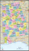
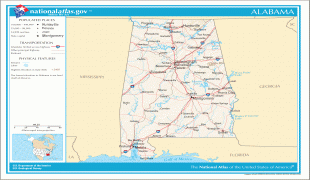
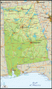
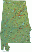
Alabama is nicknamed the Yellowhammer State, after the state bird. Alabama is also known as the "Heart of Dixie" and the "Cotton State". The state tree is the longleaf pine, and the state flower is the camellia. Alabama's capital is Montgomery, and its largest city by population and area is Huntsville. Its oldest city is Mobile, founded by French colonists in 1702 as the capital of French Louisiana. Greater Birmingham is Alabama's largest metropolitan area and its economic center.
Originally home to many native tribes, present-day Alabama was a Spanish territory beginning in the sixteenth century until the French acquired it in the early eighteenth century. The British won the territory in 1763 until losing it in the American Revolutionary War. Spain held Mobile as part of Spanish West Florida until 1813. In December 1819, Alabama was recognized as a state. During the antebellum period, Alabama was a major producer of cotton, and widely used African American slave labor. In 1861, the state seceded from the United States to become part of the Confederate States of America, with Montgomery acting as its first capital, and rejoined the Union in 1868. Following the American Civil War, Alabama would suffer decades of economic hardship, in part due to agriculture and a few cash crops being the main driver of the state's economy. Similar to other former slave states, Alabamian legislators employed Jim Crow laws which disenfranchised and discriminated against African Americans and also Alabama's French Creole population from the late 19th century up until the 1960s.
In the early 20th century, despite the growth of major industries and urban centers, white rural interests dominated the state legislature through the mid-20th century. During this time, urban interests and African Americans were markedly under-represented. High-profile events such as the Selma to Montgomery march made the state a major focal point of the civil rights movement in the 1950s and 1960s. During and after World War II, Alabama grew as the state's economy diversified with new industries. NASA's Marshall Space Flight Center in Huntsville would help Alabama's economic growth in the mid-to-late 20th century, by developing an aerospace industry. Alabama's economy in the 21st century is based on automotive, finance, tourism, manufacturing, aerospace, mineral extraction, healthcare, education, retail, and technology.
The state's geography is diverse, with the north dominated by the mountainous Tennessee Valley and the south by Mobile Bay, a historically significant port. Politically, as part of the Deep South, Alabama is predominantly a conservative state, and is known for its Southern culture. Within Alabama, American football, particularly at the college level at schools such as the University of Alabama, Auburn University, Alabama A&M University, Alabama State University, Troy University, the University of South Alabama, and Jacksonville State University, plays a major part of the state's culture.
The European-American naming of the Alabama River and state was derived from the Alabama people, a Muskogean-speaking tribe whose members lived just below the confluence of the Coosa and Tallapoosa rivers on the upper reaches of the river. In the Alabama language, the word for a person of Alabama lineage is Albaamo (or variously Albaama or Albàamo in different dialects; the plural form is Albaamaha). The word's spelling varies significantly among historical sources. The first usage appears in three accounts of the Hernando de Soto expedition of 1540: Garcilaso de la Vega used Alibamo, while the Knight of Elvas and Rodrigo Ranjel wrote Alibamu and Limamu, respectively, in transliterations of the term. As early as 1702, the French called the tribe the Alibamon, with French maps identifying the river as Rivière des Alibamons. Other spellings of the name have included Alibamu, Alabamo, Albama, Alebamon, Alibama, Alibamou, Alabamu, Allibamou. and possibly Alabahmu. The use of state names derived from Native American languages is common in the U.S.; an estimated 27 states have names of Native American origin.
Sources disagree on the word's meaning. Some scholars suggest the word comes from the Choctaw alba (meaning 'plants' or 'weeds') and amo (meaning 'to cut', 'to trim', or 'to gather'). The meaning may have been 'clearers of the thicket' or 'herb gatherers', referring to clearing land for cultivation or collecting medicinal plants. The state has numerous place names of Native American origin. However, there are no correspondingly similar words in the Alabama language.
An 1842 article in the Jacksonville Republican proposed it meant 'Here We Rest'. This notion was popularized in the 1850s through the writings of Alexander Beaufort Meek. Experts in the Muskogean languages have not found any evidence to support such a translation.
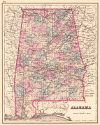
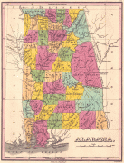
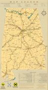
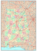
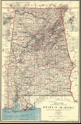
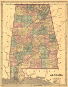
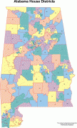
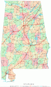
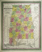
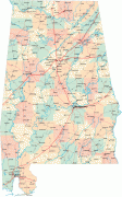
Map - Alabama
Map


Country - United_States
 |
 |
| Flag of the United States | |
Indigenous peoples have inhabited the Americas for thousands of years. Beginning in 1607, British colonization led to the establishment of the Thirteen Colonies in what is now the Eastern United States. They quarreled with the British Crown over taxation and political representation, leading to the American Revolution and proceeding Revolutionary War. The United States declared independence on July 4, 1776, becoming the first nation-state founded on Enlightenment principles of unalienable natural rights, consent of the governed, and liberal democracy. The country began expanding across North America, spanning the continent by 1848. Sectional division surrounding slavery in the Southern United States led to the secession of the Confederate States of America, which fought the remaining states of the Union during the American Civil War (1861–1865). With the Union's victory and preservation, slavery was abolished nationally by the Thirteenth Amendment.
Currency / Language
| ISO | Currency | Symbol | Significant figures |
|---|---|---|---|
| USD | United States dollar | $ | 2 |
| ISO | Language |
|---|---|
| EN | English language |
| FR | French language |
| ES | Spanish language |


