Barbuda
Historically, most of Barbuda's 1,634 residents have lived in the town of Codrington. However, in September 2017, Hurricane Irma damaged or destroyed 95% of the island's buildings and infrastructure and, as a result, all the island's inhabitants were evacuated to Antigua, leaving Barbuda empty for the first time in modern history. By February 2019, most of the residents had returned to the island.
The Pre-Arawakan peoples inhabited the area in the Stone Age. The island was populated by Arawak and Carib Indians when Christopher Columbus landed on his second voyage in 1493. Early settlements by the Spanish were followed by the French and English who formed a colony in 1666.
In 1685, Barbuda was leased to brothers John and Christopher Codrington, who had founded the town of Codrington. The Codrington family produced food and transported slaves as labour for their sugarcane plantations on Antigua. During the 1740s, there were multiple slave rebellions at Codrington and all slaves were freed in 1834.
On 1 November 1981, the island gained its independence as an integral part of Antigua and Barbuda.
Map - Barbuda
Map
Country - Antigua_and_Barbuda
 |
 |
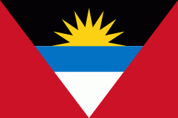
| Flag of Antigua and Barbuda | |
The country consists of two major islands, Antigua and Barbuda, which are approximately 40 km apart, and several smaller islands, including Great Bird, Green, Guiana, Long, Maiden, Prickly Pear, York, and Redonda. The permanent population is approximately 97,120 ( estimates), with 97% residing in Antigua. St. John's, Antigua, is the country's capital, major city, and largest port. Codrington is Barbuda's largest town.
Currency / Language
| ISO | Currency | Symbol | Significant figures |
|---|---|---|---|
| XCD | East Caribbean dollar | $ | 2 |
| ISO | Language |
|---|---|
| EN | English language |


