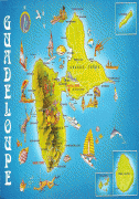
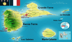
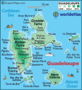
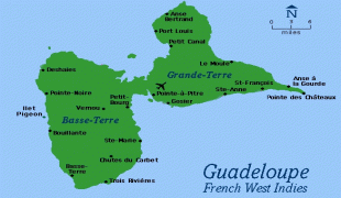
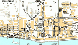
Map - Basse-Terre

Basse-Terre
Basse-Terre (, ; ; Bastè, ) is a commune in the French overseas department of Guadeloupe, in the Lesser Antilles. It is also the prefecture (capital city) of Guadeloupe. The city of Basse-Terre is located on Basse-Terre Island, the western half of Guadeloupe.

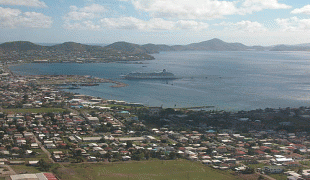
Although it is the administrative capital, Basse-Terre is only the second largest city in Guadeloupe behind Pointe-à-Pitre. Together with its urban area it had 44,864 inhabitants in 2012 (11,534 of whom lived in the city of Basse-Terre proper).

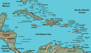
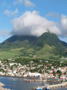
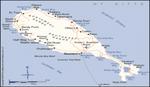
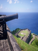
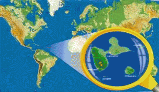
Basse-Terre is located in the south-western corner of the Basse-Terre portion of the island of Guadeloupe which is itself located some 100 km north of Dominica and some 450 km south-east of Puerto Rico. The commune is at the foot of the Soufrière volcano and is connected to the rest of the island by three main roads:

* The Route nationale 1 (Guadeloupe) which exits the commune in the south on the coast and continues inland to Gourbeyre then all the way around the coast to Pointe-à-Pitre on Grande-Terre.

* The Route nationale 2 (Guadeloupe) which goes north along the coast to Vieux Habitants and continues all the way around the coast to join the N1 at Baie Mahault.

* The N3 which traverses the length of the commune and continues to Saint-Claude inland.

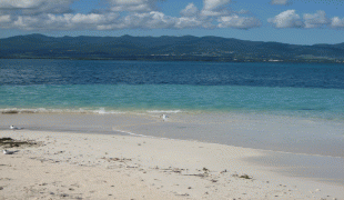
Basse-Terre has a maritime station that receives cruise ships and has a ferry service to the Îles des Saintes.

The commune is mostly urban with some farmland in the north-east and north-west.

The different districts of Basse-Terre are: Agincourt (also Saint-Claude), Bas-du-Bourg, Carmel, Desmarais (also Saint-Claude) Guillaud, Morne-Chaulet, Morne-à-Vaches (also Saint-Claude), Petit-Paris, Pintade, Rivière-des-Peres, La Rue-Maillan, Saint-François, Sur-le Morne, and Versailles.

 
Map - Basse-Terre
Map
Google Earth - Map - Basse-Terre
Google Earth
Openstreetmap - Map - Basse-Terre
Openstreetmap
Basse-terre.jpg
2592x1944
upload.wikimedia.org
GuadalupeJPEG.jpg
1118x1600
3.bp.blogspot.com
kn_map2.jpg
956x715
www.weltrekordreise....
CopiedeCopiedecarte_...
813x583
i725.photobucket.com
gpcolor.gif
642x705
www.worldatlas.com
SKB_01.jpg
428x931
media.royalcaribbean...
caribbean-map.jpg
800x480
i725.photobucket.com
caribbean-map-1.jpg
480x800
i725.photobucket.com
guadeloupemap.gif
586x451
www.basse-terre.com
Basseterre.jpeg
438x584
upload.wikimedia.org
stkitts_island.gif
552x462
www.stunttours.com
atlantic-ocean-on-on...
550x412
media-cdn.tripadviso...
st-kitts-captain-sun...
550x412
media-cdn.tripadviso...
the-fort-at-brimston...
412x550
media-cdn.tripadviso...
plan-bt.gif
595x347
www.antilles-info-to...
854477.jpg
500x375
mw2.google.com
3437476.jpg
332x500
mw2.google.com
guad.jpg
360x236
guadeloupe-vacation....
240px-Basseterre_Map...
240x257
upload.wikimedia.org
240px-Basseterre.jpe
240x180
upload.wikimedia.org
Country - Guadeloupe
Guadeloupe (Gwadloup, ) is an archipelago and overseas department and region of France in the Caribbean. It consists of four inhabited islands—Basse-Terre, Grande-Terre, Marie-Galante, La Désirade, and the two inhabited Îles des Saintes—as well as many uninhabited islands and outcroppings. It is south of Antigua and Barbuda and Montserrat, north of the Commonwealth of Dominica. The region's capital city is Basse-Terre, located on the southern west coast of Basse-Terre Island; however, the most populous city is Les Abymes and the main centre of business is neighbouring Pointe-à-Pitre, both located on Grande-Terre Island. It had a population of 384,239 in 2019.

Like the other overseas departments, it is an integral part of France. As a constituent territory of the European Union and the Eurozone, the euro is its official currency and any European Union citizen is free to settle and work there indefinitely. However, as an overseas department, it is not part of the Schengen Area. The region formerly included Saint Barthélemy and Saint Martin, which were detached from Guadeloupe in 2007 following a 2003 referendum.
Map - GuadeloupeGuadeloupe.JPG
Guadeloupe.JPG
1750x1270
freemapviewer.org
Map - Guadeloupe1815_Thomson_Map_of_Guadaloupe%2C_Antigua%2C_Marie_Galante_%28_West_Indies_%29_-_Geographicus_-_Guadaloupe-t-15.jpg
1815_Thomson_Map_of_...
5000x4262
freemapviewer.org
Map - Guadeloupe1015px-Guadeloupe_department_location_map.svg.png
1015px-Guadeloupe_de...
1015x890
freemapviewer.org
Map - GuadeloupeGuadeloupe_department_relief_location_map.jpg
Guadeloupe_departmen...
1015x890
freemapviewer.org
Map - GuadeloupeGuadeloupe_16.1890N_6.5901W_Landsat7.jpg
Guadeloupe_16.1890N_...
4704x3918
freemapviewer.org
Currency / Language  
ISO Currency Symbol Significant figures
EUR Euro € 2
ISO Language
FR French language
Neighbourhood - Country