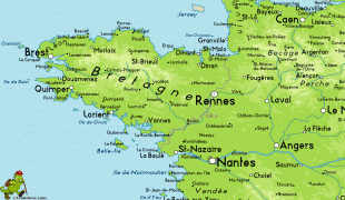
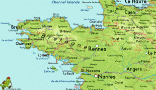
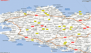
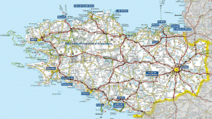
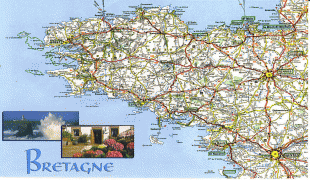
Brittany (Bretagne)
 |
 |
Brittany has also been referred to as Little Britain (as opposed to Great Britain, with which it shares an etymology). It is bordered by the English Channel to the north, Normandy to the northeast, eastern Pays de la Loire to the southeast, the Bay of Biscay to the south, and the Celtic Sea and the Atlantic Ocean to the west. Its land area is 34,023 km2 (13,136 sq mi).
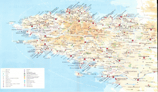
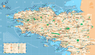
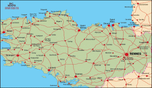
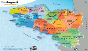
Brittany is the site of some of the world's oldest standing architecture, home to the Cairn of Barnenez, the Tumulus Saint-Michel and others, which date to the early 5th millennium BC. Today, the historical province of Brittany is split among five French departments: Finistère in the west, Côtes-d'Armor in the north, Ille-et-Vilaine in the northeast, Morbihan in the south and Loire-Atlantique in the southeast. Loire-Atlantique now belongs to the Pays de la Loire region while the other four departments make up the Brittany region.
At the 2010 census, the population of historic Brittany was estimated to be 4,475,295. In 2017, the largest metropolitan areas were Nantes (934,165 inhabitants), Rennes (733,320 inhabitants), and Brest (321,364 inhabitants). Brittany is the traditional homeland of the Breton people and is one of the six Celtic nations, retaining a distinct cultural identity that reflects its history. A nationalist movement seeks greater autonomy within the French Republic, or independence from it.
The word Brittany, along with its French, Breton and Gallo equivalents Bretagne, Breizh and Bertaèyn, derive from the Latin Britannia, which means "land of the Britons". This word had been used by the Romans since the 1st century to refer to Great Britain, and more specifically the Roman province of Britain. This word derives from a Greek word, Πρεττανικη (Prettanike) or Βρεττανίαι (Brettaniai), used by Pytheas, an explorer from Massalia who visited the British Isles around 320 BC. The Greek word itself comes from the common Brythonic ethnonym reconstructed as *Pritanī, itself from Proto-Celtic *kʷritanoi (ultimately from Proto-Indo-European *kʷer- 'to cut, make').
The Romans called Brittany Armorica. It was a quite indefinite region that extended along the English Channel coast from the Seine estuary, then along the Atlantic coast to the Loire estuary and, according to several sources, maybe to the Garonne estuary. This term probably comes from a Gallic word, aremorica, which means "close to the sea". Another name, Letauia (in English "Litavis"), was used until the 12th century. It possibly means "wide and flat" or "to expand" and it gave the Welsh name for Brittany: Llydaw.
After the fall of the Western Roman Empire, many Britons settled in western Armorica, and the region started to be called Britannia, although this name only replaced Armorica in the sixth century or perhaps by the end of the fifth.
Breton-speaking people may pronounce the word Breizh in two different ways, according to their region of origin. Breton can be divided into two main dialects: the KLT (Kerne-Leon-Tregor) and the dialect of Vannes. KLT speakers pronounce it and would write it Breiz, while the Vannetais speakers pronounce it and would write it Breih. The official spelling is a compromise between both variants, with a z and an h together. In 1941, efforts to unify the dialects led to the creation of the so-called Breton zh, a standard which has never been widely accepted. On its side, Gallo has never had a widely accepted writing system and several ones coexist. For instance, the name of the region in that language can be written Bertaèyn in ELG script, or Bertègn in MOGA, and a couple of other scripts also exist.
Map - Brittany (Bretagne)
Map


Country - France
 |
 |
| Flag of France | |
Inhabited since the Palaeolithic era, the territory of Metropolitan France was settled by Celtic tribes known as Gauls during the Iron Age. Rome annexed the area in 51 BC, leading to a distinct Gallo-Roman culture that laid the foundation of the French language. The Germanic Franks formed the Kingdom of Francia, which became the heartland of the Carolingian Empire. The Treaty of Verdun of 843 partitioned the empire, with West Francia becoming the Kingdom of France in 987. In the High Middle Ages, France was a powerful but highly decentralised feudal kingdom. Philip II successfully strengthened royal power and defeated his rivals to double the size of the crown lands; by the end of his reign, France had emerged as the most powerful state in Europe. From the mid-14th to the mid-15th century, France was plunged into a series of dynastic conflicts involving England, collectively known as the Hundred Years' War, and a distinct French identity emerged as a result. The French Renaissance saw art and culture flourish, conflict with the House of Habsburg, and the establishment of a global colonial empire, which by the 20th century would become the second-largest in the world. The second half of the 16th century was dominated by religious civil wars between Catholics and Huguenots that severely weakened the country. France again emerged as Europe's dominant power in the 17th century under Louis XIV following the Thirty Years' War. Inadequate economic policies, inequitable taxes and frequent wars (notably a defeat in the Seven Years' War and costly involvement in the American War of Independence) left the kingdom in a precarious economic situation by the end of the 18th century. This precipitated the French Revolution of 1789, which overthrew the Ancien Régime and produced the Declaration of the Rights of Man, which expresses the nation's ideals to this day.
Currency / Language
| ISO | Currency | Symbol | Significant figures |
|---|---|---|---|
| EUR | Euro | € | 2 |
| ISO | Language |
|---|---|
| EU | Basque language |
| BR | Breton language |
| CA | Catalan language |
| CO | Corsican language |
| FR | French language |
| OC | Occitan language |


