Map - Domagnano (Castello di Domagnano)

Domagnano (Castello di Domagnano)
Domagnano is a municipality in San Marino. It has 3,565 inhabitants (May 2018) in an area of 6.62 km2.

It borders the San Marino municipalities Faetano, Borgo Maggiore, Serravalle and the Italian municipality Coriano.

 
Map - Domagnano (Castello di Domagnano)
Map
Google Earth - Map - Domagnano
Google Earth
Openstreetmap - Map - Domagnano
Openstreetmap
Map - Domagnano - Esri.WorldImagery
Esri.WorldImagery
Map - Domagnano - Esri.WorldStreetMap
Esri.WorldStreetMap
Map - Domagnano - OpenStreetMap.Mapnik
OpenStreetMap.Mapnik
Map - Domagnano - OpenStreetMap.HOT
OpenStreetMap.HOT
Map - Domagnano - OpenTopoMap
OpenTopoMap
Map - Domagnano - CartoDB.Positron
CartoDB.Positron
Map - Domagnano - CartoDB.Voyager
CartoDB.Voyager
Map - Domagnano - OpenMapSurfer.Roads
OpenMapSurfer.Roads
Map - Domagnano - Esri.WorldTopoMap
Esri.WorldTopoMap
Map - Domagnano - Stamen.TonerLite
Stamen.TonerLite
Country - San_Marino
Flag of San Marino
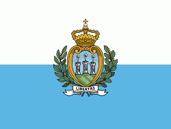
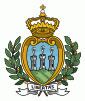
San Marino, officially the Republic of San Marino (Repubblica di San Marino; Ripóbblica d' San Marein), also known as the Most Serene Republic of San Marino (Serenissima Repubblica di San Marino), is the fifth-smallest country in the world and a European microstate in Southern Europe enclaved by Italy. Located on the northeastern side of the Apennine Mountains, San Marino covers a land area of just over 61 km2, and has a population of 33,562.

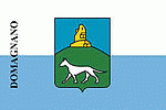
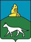
San Marino is a landlocked country; however, its northeastern end is within 10 km of the Italian city of Rimini on the Adriatic coast. The nearest airport is also in Italy. The country's capital city, the City of San Marino, is located atop Monte Titano, while its largest settlement is Dogana within the largest municipality of Serravalle. San Marino's official language is Italian.
Map - San MarinoSan_marino_map.png
San_marino_map.png
1159x1504
freemapviewer.org
Map - San MarinoSan_Marino_map.jpg
San_Marino_map.jpg
938x1098
freemapviewer.org
Map - San MarinoSan-marino-map.png
San-marino-map.png
1066x1124
freemapviewer.org
Currency / Language  
ISO Currency Symbol Significant figures
EUR Euro € 2
ISO Language
IT Italian language
Neighbourhood - Country  
  •  Italy 
Administrative Subdivision
City, Village,...