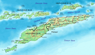
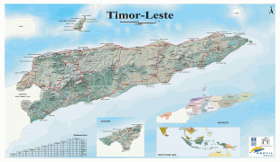
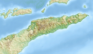
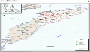
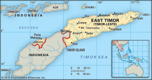
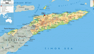
East Timor (Democratic Republic of Timor-Leste)
 |
 |
| Flag of East Timor | |
East Timor came under Portuguese influence in the sixteenth century, remaining a Portuguese colony until 1975. Internal conflict preceded a unilateral declaration of independence and an Indonesian invasion and annexation. Resistance continued throughout Indonesian rule, and in 1999 a United Nations–sponsored act of self-determination led to Indonesia relinquishing control of the territory. On 20 May 2002, as Timor-Leste, it became the first new sovereign state of the 21st century. That same year, relations with Indonesia were established and normalized, with Indonesia also supporting East Timor's accession into ASEAN.
The national government runs on a semi-presidential system, with the popularly elected president sharing power with a prime minister appointed by the National Parliament. Power is centralised under the national government, although many local leaders have informal influence. The country maintains a policy of international cooperation, and is a member of the Community of Portuguese Language Countries, an observer of the Pacific Islands Forum, and an applicant for ASEAN membership. The country remains relatively poor, with an economy that relies heavily on natural resources, especially oil, and foreign aid.
The total population is over 1.1 million, and is heavily skewed towards young people due to a high fertility rate. Education has led to the increasing literacy over the past half-century, especially in the two official languages of Portuguese and Tetum. High ethnic and linguistic diversity is reflected by the 30 indigenous languages spoken in the country. The majority of the population is Catholic, which exists alongside strong local traditions, especially in rural areas.
"Timor" is derived from timur, meaning in Malay, thus resulting in a tautological place name meaning. In Indonesian, this results in the name Timor Timur. In Portuguese, the country is called Timor-Leste (Leste meaning ). In Tetum it is Timór Lorosa'e (Lorosa'e can be literally translated as ).
The official names under its constitution are "Democratic Republic of Timor-Leste" in English, "República Democrática de Timor-Leste" in Portuguese, and "Repúblika Demokrátika Timór-Leste" in Tetum. The official short form of the name is "Timor-Leste", and it uses the ISO codes TLS & TL.
Currency / Language
| ISO | Currency | Symbol | Significant figures |
|---|---|---|---|
| USD | United States dollar | $ | 2 |
| ISO | Language |
|---|---|
| EN | English language |
| ID | Indonesian language |
| PT | Portuguese language |