Grantley Adams International Airport (Grantley Adams International Airport)
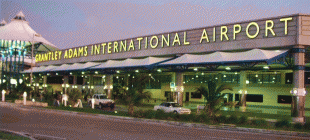
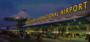
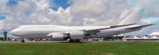
Grantley Adams International Airport (GAIA) is an international airport at Seawell, Christ Church, Barbados, serving as the country's only port of entry by air.
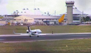
The airport is the only designated port of entry for persons arriving and departing by air in Barbados and operates as one of the major gateways to the Eastern Caribbean. It has direct service to destinations in the United States, Canada, Central America and Europe. In 2016, the airport was the eighth-busiest airport in the Caribbean region and the third-busiest airport in the Lesser Antilles after Queen Beatrix International Airport on Aruba and Pointe-à-Pitre International Airport on Guadeloupe. GAIA, also remains an important air-link for cruise ship passengers departing and arriving at the Port of Bridgetown, and a base of operations for the Regional Security System (RSS), and the Regional (Caribbean) Police Training Centre.
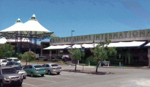
The airport's former name was Seawell Airport before being dedicated posthumously in honour of the first Premier of Barbados, Sir Grantley Herbert Adams in 1976. The airport is in the Atlantic time zone (UTC−4:00) and is in World Area Code region No. 246 (by the US Department of Transportation). It was a hub for now-defunct Barbadian carriers Caribbean Airways (not to be confused with the currently-as of 2021-operating Caribbean Airlines) and REDjet, the home for the charter carrier West Indies Executive Air, and former home to the flight training school Coconut Airways.
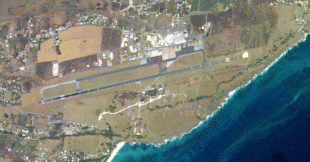
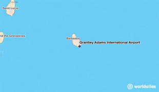
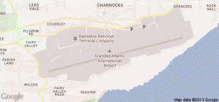
Grantley Adams International Airport lies 12.9 km from the centre of the capital city Bridgetown, in an area officially known as Seawell. This is contrary to most information services stating the airport as being inside the capital. Grantley Adams Airport is the main air transportation hub for the Eastern Caribbean.
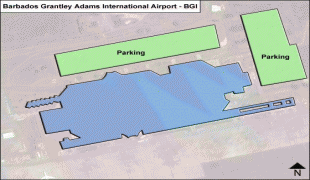
The terrain is relatively flat and quite suburban. The airport lies in the south-eastern portion of parish of Christ Church, close to the southern tip of the island. The airport has easy access to the ABC Highway/highway 7 heading towards the capital and locations to the north and west coast.
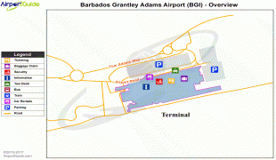
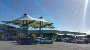
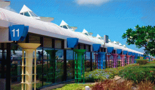
The airport has recently undergone a multi-phase US$100 million upgrade and expansion by the government, which added a new arrivals hall adjacent to the prior arrivals/departures terminals. Construction was made slightly more complicated because the airport has to remain open for up to 16 hours per day. Its current infrastructure is supposed to meet the needs of Barbados until at least 2015. The phase III construction project, which is yet to be completed will see changes made to the aeroplane parking configuration.
The airport is the only designated port of entry for persons arriving and departing by air in Barbados and operates as one of the major gateways to the Eastern Caribbean. It has direct service to destinations in the United States, Canada, Central America and Europe. In 2016, the airport was the eighth-busiest airport in the Caribbean region and the third-busiest airport in the Lesser Antilles after Queen Beatrix International Airport on Aruba and Pointe-à-Pitre International Airport on Guadeloupe. GAIA, also remains an important air-link for cruise ship passengers departing and arriving at the Port of Bridgetown, and a base of operations for the Regional Security System (RSS), and the Regional (Caribbean) Police Training Centre.
The airport's former name was Seawell Airport before being dedicated posthumously in honour of the first Premier of Barbados, Sir Grantley Herbert Adams in 1976. The airport is in the Atlantic time zone (UTC−4:00) and is in World Area Code region No. 246 (by the US Department of Transportation). It was a hub for now-defunct Barbadian carriers Caribbean Airways (not to be confused with the currently-as of 2021-operating Caribbean Airlines) and REDjet, the home for the charter carrier West Indies Executive Air, and former home to the flight training school Coconut Airways.
Grantley Adams International Airport lies 12.9 km from the centre of the capital city Bridgetown, in an area officially known as Seawell. This is contrary to most information services stating the airport as being inside the capital. Grantley Adams Airport is the main air transportation hub for the Eastern Caribbean.
The terrain is relatively flat and quite suburban. The airport lies in the south-eastern portion of parish of Christ Church, close to the southern tip of the island. The airport has easy access to the ABC Highway/highway 7 heading towards the capital and locations to the north and west coast.
The airport has recently undergone a multi-phase US$100 million upgrade and expansion by the government, which added a new arrivals hall adjacent to the prior arrivals/departures terminals. Construction was made slightly more complicated because the airport has to remain open for up to 16 hours per day. Its current infrastructure is supposed to meet the needs of Barbados until at least 2015. The phase III construction project, which is yet to be completed will see changes made to the aeroplane parking configuration.
| IATA Code | BGI | ICAO Code | TBPB | FAA Code | |
|---|---|---|---|---|---|
| Telephone | Fax | ||||
| Home page |
Map - Grantley Adams International Airport (Grantley Adams International Airport)
Map


Country - Barbados
 |
 |
| Flag of Barbados | |
Inhabited by Kalinago people since the 13th century, and prior to that by other Amerindians, Spanish navigators took possession of Barbados in the late 15th century, claiming it for the Crown of Castile. It first appeared on a Spanish map in 1511. The Portuguese Empire claimed the island between 1532 and 1536, but abandoned it in 1620 with their only remnants being an introduction of wild boars for a good supply of meat whenever the island was visited. An English ship, the Olive Blossom, arrived in Barbados on 14 May 1625; its men took possession of the island in the name of King James I. In 1627, the first permanent settlers arrived from England, and Barbados became an English and later British colony. During this period, the colony operated on a plantation economy, relying on the labour of African slaves who worked on the island's plantations. Slavery continued until it was phased out through most of the British Empire by the Slavery Abolition Act 1833.
Currency / Language
| ISO | Currency | Symbol | Significant figures |
|---|---|---|---|
| BBD | Barbados dollar | $ | 2 |
| USD | United States dollar | $ | 2 |
| ISO | Language |
|---|---|
| EN | English language |