Marsa Alam International Airport (Marsa Alam International Airport)
Marsa Alam International Airport is an international airport located 60 km north of Marsa Alam in Egypt. It is an important destination for leisure flights from Europe.
It was built in response to the increasing needs of European travelers to this southern Red Sea destination, along with other airports on the Red Sea such as Hurghada International Airport, being inaugurated on 16 October 2003. The official name of the airport until 2011 was Marsa Mubarak Airport. The airport is privately owned and operated by EMAK Marsa Alam for Management & Operation Airports, a subsidiary of the M.A. Al-Kharafi Group of Kuwait.
It was built in response to the increasing needs of European travelers to this southern Red Sea destination, along with other airports on the Red Sea such as Hurghada International Airport, being inaugurated on 16 October 2003. The official name of the airport until 2011 was Marsa Mubarak Airport. The airport is privately owned and operated by EMAK Marsa Alam for Management & Operation Airports, a subsidiary of the M.A. Al-Kharafi Group of Kuwait.
| IATA Code | RMF | ICAO Code | HEMA | FAA Code | |
|---|---|---|---|---|---|
| Telephone | Fax | ||||
| Home page | Hyperlink |
Map - Marsa Alam International Airport (Marsa Alam International Airport)
Map


Country - United_Arab_Republic
 |
 |
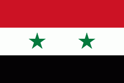
| Flag of Egypt | |
The republic was led by Egyptian President Gamal Abdel Nasser. The UAR was a member of the United Arab States, a loose confederation with the Mutawakkilite Kingdom of Yemen, which was dissolved in 1961.
Currency / Language
| ISO | Currency | Symbol | Significant figures |
|---|---|---|---|
| EGP | Egyptian pound | £ or جم | 2 |
| ISO | Language |
|---|---|
| AR | Arabic language |
| EN | English language |
| FR | French language |