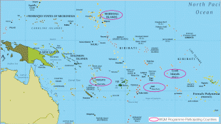
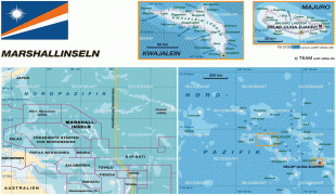
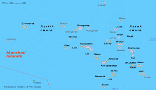
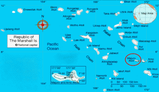
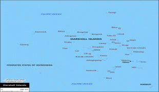
Marshall Islands (Republic of the Marshall Islands)
 |
 |
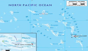
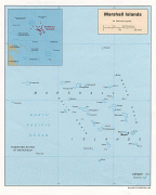
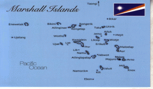
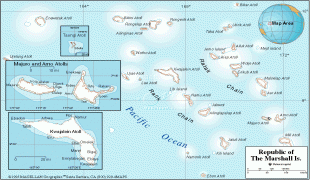
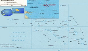
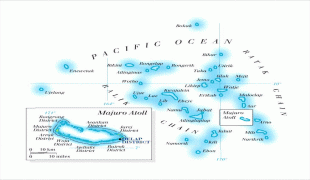
The country's population of 42,050 people (at the 2021 World Bank Census ) is spread out over five islands and 29 coral atolls, comprising 1,156 individual islands and islets. The capital and largest city is Majuro. It has the largest portion of its territory composed of water of any sovereign state, at 97.87%. The islands share maritime boundaries with Wake Island to the north, Kiribati to the southeast, Nauru to the south, and the Federated States of Micronesia to the west. About 52.3% of Marshall Islanders (27,797 at the 2011 Census) live on Majuro. In 2016, 73.3% of the population were defined as being "urban". The UN also indicates a population density of 295 PD/km2, and its projected 2020 population is 59,190.
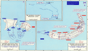
Micronesian settlers reached the Marshall Islands using canoes circa 2nd millennium BC, with interisland navigation made possible using traditional stick charts. They eventually settled there. Islands in the archipelago were first explored by Europeans in the 1520s, starting with Ferdinand Magellan, a Portuguese explorer in the service of Spain, Juan Sebastián Elcano and Miguel de Saavedra. Spanish explorer Alonso de Salazar reported sighting an atoll in August 1526. Other expeditions by Spanish and English ships followed. The islands derive their name from John Marshall, who visited in 1788. The islands were historically known by the inhabitants as "jolet jen Anij" (Gifts from God). Spain claimed the islands in 1592, and the European powers recognized its sovereignty over the islands in 1874. They had been part of the Spanish East Indies formally since 1528. Later, Spain sold some of the islands to the German Empire in 1885, and they became part of German New Guinea that year, run by the trading companies doing business in the islands, particularly the Jaluit Company. In World War I, the Empire of Japan occupied the Marshall Islands, which, in 1920, the League of Nations combined with other former German territories to form the South Seas Mandate. During World War II, the United States took control of the islands in the Gilbert and Marshall Islands campaign in 1944. Nuclear testing began on Bikini Atoll in 1946 and concluded in 1958.
The U.S. government formed the Congress of Micronesia in 1965, a plan for increased self-governance of Pacific islands. The Trust Territory of the Pacific Islands in May 1979 provided independence to the Marshall Islands, whose constitution and president (Amata Kabua) were formally recognized by the US. Full sovereignty or self-government was achieved in a Compact of Free Association with the United States. Marshall Islands has been a member of the Pacific Community (SPC) since 1983 and a United Nations member state since 1991. Politically, the Marshall Islands is a parliamentary republic with an executive presidency in free association with the United States, with the U.S. providing defense, subsidies, and access to U.S.-based agencies such as the Federal Communications Commission and the United States Postal Service. With few natural resources, the islands' wealth is based on a service economy, as well as fishing and agriculture; aid from the United States represents a large percentage of the islands' gross domestic product, but most financial aid from the Compact of Free Association expires in 2023. , negotiations regarding an extension of the aid period were ongoing. The country uses the United States dollar as its currency. In 2018, it also announced plans for a new cryptocurrency to be used as legal tender.
The majority of the citizens of the Republic of Marshall Islands are of Marshallese descent, though there are small numbers of immigrants from the United States, China, Philippines, and other Pacific islands. The two official languages are Marshallese, which is one of the Oceanic languages, and English. Almost the entire population of the islands practices some religion: three-quarters of the country follows either the United Church of Christ – Congregational in the Marshall Islands (UCCCMI) or the Assemblies of God.
Evidence suggests that around 3,000 years ago successive waves of human migrants from Southeast Asia spread across the Western Pacific Ocean, populating its many small islands. The Marshall Islands were settled by Micronesians in the 2nd millennium BC. Little is known of the islands' early history. Marshall Islanders, among the many great Oceanic voyagers, designed stick charts to map ocean swells and navigate between the islands. Present-day seafaring, however, has remained an extension of maritime culture across the archipelago.
The Spanish explorer Alonso de Salazar landed there in 1526, and the archipelago came to be known as "Los Pintados" ("The Painted (Ones)", possibly referring to the indigenous people first found there), "Las Hermanas" ("The Sisters") and "Los Jardines" ("The Gardens") within the Spanish Empire. It first fell within the jurisdiction of the Viceroyalty of New Spain, and was then administered by Madrid, through the Captaincy General of the Philippines, upon the independence of Latin America and the dissolution of New Spain starting in 1821.
American whaling ships visited the islands in the 19th century. The first on record was the Awashonks in 1835 and last was the Andrews Hicks in 1905.
The islands were only formally possessed by Spain for much of their colonial history, and on European maps were grouped with the Caroline Islands which today make up Palau and the Federated States of Micronesia, or alternatively the "Nuevas Filipinas" ("New Philippines"). The islands were mostly left to their own affairs except for short-lived religious missions (documented in 1668 and 1731) during the 16th and 17th centuries. They were largely ignored by European powers except for cartographic demarcation treaties between the Iberian Empires (Portugal and Castilian Spain) in 1529, 1750 and 1777. The archipelago corresponding to the present-day country was independently named by Krusenstern, after British explorer John Marshall, who visited them together with Thomas Gilbert in 1788, en route from Botany Bay to Canton with two ships of the First Fleet, and started to establish German and British trading posts, which were not formally contested by Spain.
The Marshall Islands were formally claimed by Spain in 1874 through its capital in the East Indies, Manila. This marked the start of several strategic moves by the German Empire during the 1870s and 80s to annex them (claiming them to be "by chance unoccupied"). This policy culminated in a tense naval episode in 1885, which did not degenerate into a conflict due to the poor readiness of Spain's naval forces and the unwillingness for open military action from the German side.