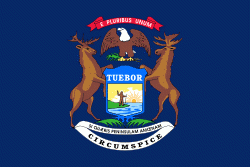
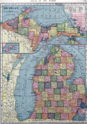
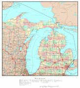
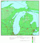
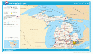
Michigan
 |
 |
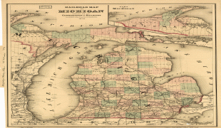
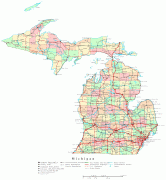
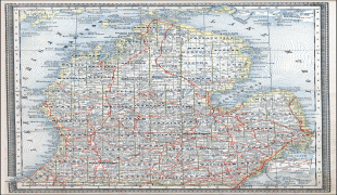
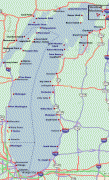
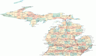
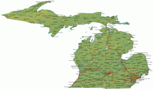
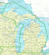
Michigan consists of two peninsulas. The Lower Peninsula resembles the shape of a mitten, and comprises a majority of the state's land area. The Upper Peninsula (often called "the U.P.") is separated from the Lower Peninsula by the Straits of Mackinac, a 5 mi channel that joins Lake Huron to Lake Michigan. The Mackinac Bridge connects the peninsulas. Michigan has the longest freshwater coastline of any political subdivision in the United States, being bordered by four of the five Great Lakes and Lake St. Clair. It also has 64,980 inland lakes and ponds. Michigan has the second-most water of any state, behind only Alaska.
The area was first occupied by a succession of Native American tribes over thousands of years. In the 17th century, French explorers claimed it as part of the New France colony, when it was largely inhabited by indigenous peoples. French and Canadian traders and settlers, Métis, and others migrated to the area, settling largely along the waterways. After France's defeat in the French and Indian War in 1762, the region came under British rule. Britain ceded the territory to the newly independent United States after Britain's defeat in the American Revolutionary War.
The area was part of the larger Northwest Territory until 1800, when western Michigan became part of the Indiana Territory. Michigan Territory was formed in 1805, but some of the northern border with Canada was not agreed upon until after the War of 1812. Michigan was admitted into the Union in 1837 as the 26th state, a free one. It soon became an important center of industry and trade in the Great Lakes region, attracting immigrants in the late 19th and early 20th centuries from many European countries. Immigrants from Finland, Macedonia, and the Netherlands were especially numerous. Migration from Appalachia and of Black Southerners as part of the Great Migration increased in the 1930s, with many settling in Metro Detroit.
Although Michigan has developed a diverse economy, in the early 20th century it became widely known as the center of the U.S. automotive industry, which developed as a major national economic force. It is home to the country's three major automobile companies (whose headquarters are all in Metro Detroit). Once exploited for logging and mining, today the sparsely populated Upper Peninsula is important for tourism due to the abundance of natural resources. The Lower Peninsula is a center of manufacturing, forestry, agriculture, services, and high-tech industry.
When the first European explorers arrived, the most populous tribes were Algonquian peoples, who include the Anishinaabe groups of Ojibwe, Odaawaa/Odawa (Ottawa), and the Boodewaadamii/Bodéwadmi (Potawatomi). The three nations coexisted peacefully as part of a loose confederation called the Council of Three Fires. The Ojibwe, whose numbers are estimated to have been between 25,000 and 35,000, were the largest.
The Ojibwe Indians (also known as Chippewa in the U.S.), an Anishinaabe tribe, were established in Michigan's Upper Peninsula and northern and central Michigan. Bands also inhabited Ontario and southern Manitoba, Canada; and northern Wisconsin, and northern and north-central Minnesota. The Ottawa Indians lived primarily south of the Straits of Mackinac in northern, western, and southern Michigan, but also in southern Ontario, northern Ohio, and eastern Wisconsin. The Potawatomi were in southern and western Michigan, in addition to northern and central Indiana, northern Illinois, southern Wisconsin, and southern Ontario. Other Algonquian tribes in Michigan, in the south and east, were the Mascouten, the Menominee, the Miami, the Sac (or Sauk), and the Meskwaki (Fox). The Wyandot were an Iroquoian-speaking people in this area; they were historically known as the Huron by the French, and were the historical adversaries of the Iroquois Confederation.
Map - Michigan
Map


Country - United_States
 |
 |
| Flag of the United States | |
Indigenous peoples have inhabited the Americas for thousands of years. Beginning in 1607, British colonization led to the establishment of the Thirteen Colonies in what is now the Eastern United States. They quarreled with the British Crown over taxation and political representation, leading to the American Revolution and proceeding Revolutionary War. The United States declared independence on July 4, 1776, becoming the first nation-state founded on Enlightenment principles of unalienable natural rights, consent of the governed, and liberal democracy. The country began expanding across North America, spanning the continent by 1848. Sectional division surrounding slavery in the Southern United States led to the secession of the Confederate States of America, which fought the remaining states of the Union during the American Civil War (1861–1865). With the Union's victory and preservation, slavery was abolished nationally by the Thirteenth Amendment.
Currency / Language
| ISO | Currency | Symbol | Significant figures |
|---|---|---|---|
| USD | United States dollar | $ | 2 |
| ISO | Language |
|---|---|
| EN | English language |
| FR | French language |
| ES | Spanish language |


