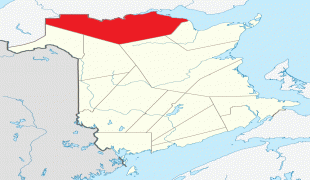
New Brunswick (New Brunswick/Nouveau-Brunswick)
 |
 |
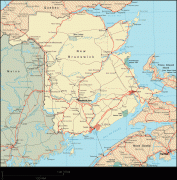
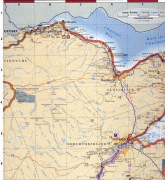
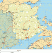
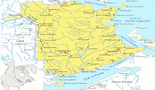
New Brunswick is bordered by Quebec to the north, Nova Scotia to the east, the Gulf of Saint Lawrence to the northeast, the Bay of Fundy to the southeast, and the U.S. state of Maine to the west. New Brunswick is about 83% forested and its northern half is occupied by the Appalachians. The province's climate is continental with snowy winters and temperate summers.
New Brunswick has a surface area of 72908 km2 and 775,610 inhabitants (2021 census). Atypically for Canada, only about half of the population lives in urban areas. New Brunswick's largest cities are Moncton and Saint John, while its capital is Fredericton.
In 1969, New Brunswick passed the Official Languages Act which began recognizing French as an official language, along with English. New Brunswickers have the right to receive provincial government services in the official language of their choice. About 2⁄3 of the population are English speaking and 1⁄3 is French speaking. New Brunswick is home to most of the cultural region of Acadia and most Acadians. New Brunswick's variety of French is called Acadian French and 7 regional accents can be found.
New Brunswick was first inhabited by First Nations like the Miꞌkmaq and Maliseet. In 1604, Acadia, the first New France colony, was founded with the creation of Port-Royal. For 150 years afterwards, Acadia changed hands a few times due to numerous conflicts between France and the United Kingdom. From 1755 to 1764, the British deported Acadians en masse, an event known as the Great Upheaval. This, along with the Treaty of Paris, solidified Acadia as British property. In 1784, following the arrival of many loyalists fleeing the American Revolution, the colony of New Brunswick was officially created, separating it from what is now Nova Scotia. In the early 1800s, New Brunswick prospered and the population grew rapidly. In 1867, New Brunswick decided to confederate with Nova Scotia and the Province of Canada (now Quebec and Ontario) to form Canada. After Confederation, shipbuilding and lumbering declined, and protectionism disrupted trade with New England.
From the mid-1900s onwards, New Brunswick was one of the poorest regions of Canada, a fact eventually mitigated by transfer payments. However, the province has seen the highest eastward migration in 45 years in both rural and urban areas, as people living in Ontario and other parts of Canada migrate to the area. As of 2002, the provincial GDP was derived as follows: services (about half being government services and public administration) 43%; construction, manufacturing, and utilities 24%; real estate rental 12%; wholesale and retail 11%; agriculture, forestry, fishing, hunting, mining, oil and gas extraction 5%; transportation and warehousing 5%. A powerful corporate concentration of large companies in New Brunswick, including most newspapers, are owned by the Irving Group of Companies. The province's 2019 output was CA$38.236 billion, which is 1.65% of Canada's GDP.
Tourism accounts for 9% of the labour force either directly or indirectly. Popular destinations include the Hopewell Rocks, Fundy National Park, Magnetic Hill, Kouchibouguac National Park and Roosevelt Campobello International Park.
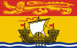
New Brunswick was named in 1784 in honour of George III, King of Great Britain, King of Ireland, and prince-elector of Brunswick-Lüneburg in what is now Germany.
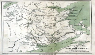
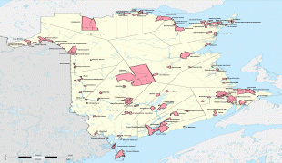
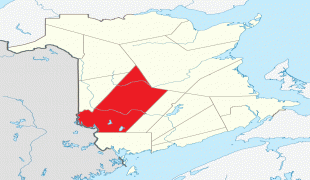
Map - New Brunswick (New Brunswick/Nouveau-Brunswick)
Map


Country - Canada
 |
 |
| Flag of Canada | |
Indigenous peoples have continuously inhabited what is now Canada for thousands of years. Beginning in the 16th century, British and French expeditions explored and later settled along the Atlantic coast. As a consequence of various armed conflicts, France ceded nearly all of its colonies in North America in 1763. In 1867, with the union of three British North American colonies through Confederation, Canada was formed as a federal dominion of four provinces. This began an accretion of provinces and territories and a process of increasing autonomy from the United Kingdom. This widening autonomy was highlighted by the Statute of Westminster 1931 and culminated in the Canada Act 1982, which severed the vestiges of legal dependence on the Parliament of the United Kingdom.
Currency / Language
| ISO | Currency | Symbol | Significant figures |
|---|---|---|---|
| CAD | Canadian dollar | $ | 2 |
| ISO | Language |
|---|---|
| EN | English language |
| FR | French language |
| IU | Inuktitut |


