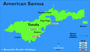
Pago Pago (Pago Pago)
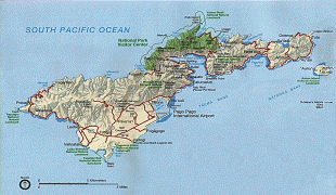
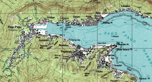
Pago Pago (Samoan: ) is the territorial capital of American Samoa. It is in Maoputasi County on Tutuila, which is American Samoa's main island.
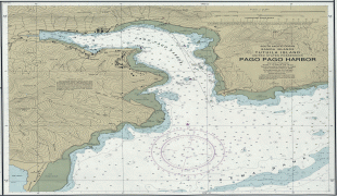
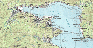
Pago Pago is home to one of the deepest natural deepwater harbors in the South Pacific Ocean, sheltered from wind and rough seas, and strategically located. The harbor is also one of the best protected in the South Pacific, which gives American Samoa a natural advantage because it makes landing fish for processing easier. Tourism, entertainment, food, and tuna canning are its main industries. As of 1993, Pago Pago was the world's fourth-largest tuna processor. It was home to two of the largest tuna companies in the world: Chicken of the Sea and StarKist, which together exported an estimated $445 million in canned tuna to the U.S. mainland. The total value of fish landed in Pago Pago — about $200,000,000 annually — is higher than in any other port in any U.S. state or territory.
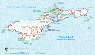
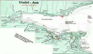
Pago Pago is the only modern urban center in American Samoa, and the main port of American Samoa. It is also home to the territorial government, all the industry, and most of the commerce in American Samoa. The Greater Pago Pago Metropolitan Area encompasses several villages strung together along Pago Pago Harbor. One of the villages is itself named Pago Pago, and in 2010 that village had a population of 3,656. The constituent villages are: Utulei, Fagatogo, Malaloa, Pago Pago, Satala and Atu'u. Fagatogo is the downtown area, referred to as "town", and is home to the legislature, while the executive seat is in Utulei. Also in Fagatogo are the Fono, police department, the Port of Pago Pago, and many shops and hotels. In 2000, the Greater Pago Pago area was home to 8,000 residents; by 2010 the population had increased to 15,000.
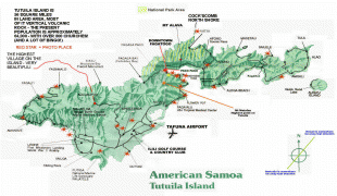
Rainmaker Mountain (Mount Pioa), which is located in Pago Pago, contributes to a weather pattern that results in the city having the highest annual rainfall of any harbor in the world. It stands protectively over the eastern side of Pago Pago, making the harbor one of the most sheltered deepwater anchorages in the Pacific Ocean.
Historically, the strategic location of Pago Pago Bay played a direct role in the political separation of Western and Eastern Samoa. The initial reason that the U.S. was interested in Tutuila was its desire to use Pago Pago Harbor as a coaling station. The town has the distinction of being the southernmost U.S. capital, and the only one located in the Southern Hemisphere.
The letter "g" in Samoan sounds like "ng"; thus Pago Pago is pronounced "Pango Pango."
An early name for Pago Pago was Long Bay (Samoan: O le Fagaloa), which was a name used by the first permanent inhabitants to settle in the Pago Pago area. It was also called O le Maputasi ("The Single Chief's House") in compliment to the Mauga, who lived at Gagamoe in Pago Pago and was the senior to all the other chiefs in the area.
Pago Pago is home to one of the deepest natural deepwater harbors in the South Pacific Ocean, sheltered from wind and rough seas, and strategically located. The harbor is also one of the best protected in the South Pacific, which gives American Samoa a natural advantage because it makes landing fish for processing easier. Tourism, entertainment, food, and tuna canning are its main industries. As of 1993, Pago Pago was the world's fourth-largest tuna processor. It was home to two of the largest tuna companies in the world: Chicken of the Sea and StarKist, which together exported an estimated $445 million in canned tuna to the U.S. mainland. The total value of fish landed in Pago Pago — about $200,000,000 annually — is higher than in any other port in any U.S. state or territory.
Pago Pago is the only modern urban center in American Samoa, and the main port of American Samoa. It is also home to the territorial government, all the industry, and most of the commerce in American Samoa. The Greater Pago Pago Metropolitan Area encompasses several villages strung together along Pago Pago Harbor. One of the villages is itself named Pago Pago, and in 2010 that village had a population of 3,656. The constituent villages are: Utulei, Fagatogo, Malaloa, Pago Pago, Satala and Atu'u. Fagatogo is the downtown area, referred to as "town", and is home to the legislature, while the executive seat is in Utulei. Also in Fagatogo are the Fono, police department, the Port of Pago Pago, and many shops and hotels. In 2000, the Greater Pago Pago area was home to 8,000 residents; by 2010 the population had increased to 15,000.
Rainmaker Mountain (Mount Pioa), which is located in Pago Pago, contributes to a weather pattern that results in the city having the highest annual rainfall of any harbor in the world. It stands protectively over the eastern side of Pago Pago, making the harbor one of the most sheltered deepwater anchorages in the Pacific Ocean.
Historically, the strategic location of Pago Pago Bay played a direct role in the political separation of Western and Eastern Samoa. The initial reason that the U.S. was interested in Tutuila was its desire to use Pago Pago Harbor as a coaling station. The town has the distinction of being the southernmost U.S. capital, and the only one located in the Southern Hemisphere.
The letter "g" in Samoan sounds like "ng"; thus Pago Pago is pronounced "Pango Pango."
An early name for Pago Pago was Long Bay (Samoan: O le Fagaloa), which was a name used by the first permanent inhabitants to settle in the Pago Pago area. It was also called O le Maputasi ("The Single Chief's House") in compliment to the Mauga, who lived at Gagamoe in Pago Pago and was the senior to all the other chiefs in the area.
Map - Pago Pago (Pago Pago)
Map


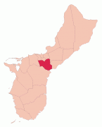


Country - American_Samoa
 |
 |
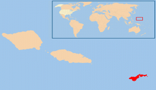
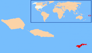
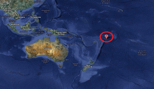
American Samoa consists of five main islands and two coral atolls; the largest and most populous island is Tutuila, with the Manuʻa Islands, Rose Atoll and Swains Island also included in the territory. All islands except for Swains Island are part of the Samoan Islands, The total land area is 199 sqkm, slightly more than Washington, D.C. As of 2022, the population of American Samoa is approximately 45,443 people, of whom the vast majority are indigenous ethnic Samoans. Most American Samoans are bilingual and can speak English and Samoan fluently.
Currency / Language
| ISO | Currency | Symbol | Significant figures |
|---|---|---|---|
| USD | United States dollar | $ | 2 |
| ISO | Language |
|---|---|
| EN | English language |
| SM | Samoan language |
| TO | Tongan language |