Philadelphia International Airport (Philadelphia International Airport)
Philadelphia International Airport is the primary airport serving Philadelphia, Pennsylvania. The airport served 19.6 million passengers annually in 2021, making it the 21st busiest airport in the United States. The airport is located 7 mi from the city's downtown area and has 22 airlines that offer nearly 500 daily departures to more than 130 destinations worldwide.
Philadelphia International Airport is the largest airport serving the state of Pennsylvania. It is the fifth-largest hub for American Airlines and its primary hub for the Northeastern United States, as well as its primary European and transatlantic gateway. Additionally, the airport is a regional cargo hub for UPS Airlines and a focus city for the ultra low-cost airline Frontier Airlines.
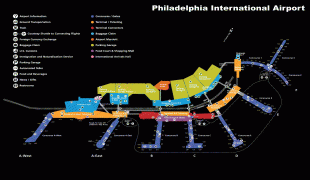
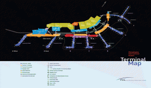
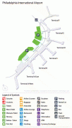
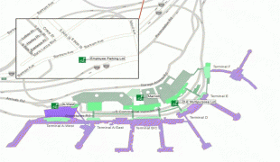
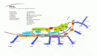
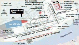
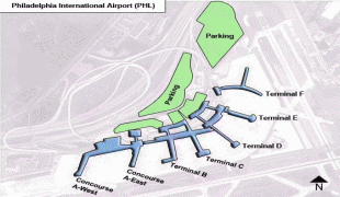
The airport has service to cities in the United States, Canada, the Caribbean, Latin America, Europe, and the Middle East. As of summer 2019, there are flights from the airport to 140 destinations, 102 domestic and 38 international. Most of the airport property is in Philadelphia proper. The international terminal and the western end of the airfield are in Tinicum Township, Delaware County. PHL covers 2,302 acres and has four runways.
Philadelphia International Airport is an important component of the economies of Philadelphia, the Delaware Valley metropolitan region to which it belongs, and the Commonwealth of Pennsylvania. The Commonwealth's Aviation Bureau reported in its Pennsylvania Air Service Monitor that the total economic impact made by the state's airports in 2004 was $22 billion. In 2017, PHL commissioned a new economic impact report. The report found PHL alone accounted for $15.4 billion in activity with over 96,000 direct and indirect jobs with $5.4 billion in total earnings. In October 2022, PHL gained a direct connection to a Colonial Pipeline fuel supply.
Starting in 1925, the Pennsylvania National Guard used the present airport site (known as Hog Island) as a training airfield. The site was dedicated as the "Philadelphia Municipal Airport" by Charles Lindbergh in 1927, but it had no proper terminal building until 1940; airlines used Camden Central Airport in nearby Pennsauken Township, New Jersey. Once Philadelphia's terminal was completed (on the east side of the field) American, Eastern, TWA, and United moved their operations here.
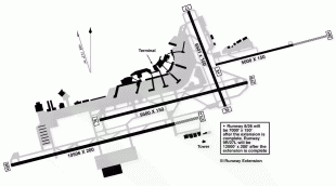
In 1947 and 1950 the airport had runways 4, 9, 12 and 17, all 5400 ft or less. In 1956 runway 9 was 7284 ft; in 1959 it was 9499 ft and runway 12 was closed. Not much changed until the early 1970s, when runway 4 was closed and 9R opened with 10500 ft.
On June 20, 1940, the airport's weather station became the official point for Philadelphia weather observations and records by the National Weather Service.
Philadelphia International Airport is the largest airport serving the state of Pennsylvania. It is the fifth-largest hub for American Airlines and its primary hub for the Northeastern United States, as well as its primary European and transatlantic gateway. Additionally, the airport is a regional cargo hub for UPS Airlines and a focus city for the ultra low-cost airline Frontier Airlines.
The airport has service to cities in the United States, Canada, the Caribbean, Latin America, Europe, and the Middle East. As of summer 2019, there are flights from the airport to 140 destinations, 102 domestic and 38 international. Most of the airport property is in Philadelphia proper. The international terminal and the western end of the airfield are in Tinicum Township, Delaware County. PHL covers 2,302 acres and has four runways.
Philadelphia International Airport is an important component of the economies of Philadelphia, the Delaware Valley metropolitan region to which it belongs, and the Commonwealth of Pennsylvania. The Commonwealth's Aviation Bureau reported in its Pennsylvania Air Service Monitor that the total economic impact made by the state's airports in 2004 was $22 billion. In 2017, PHL commissioned a new economic impact report. The report found PHL alone accounted for $15.4 billion in activity with over 96,000 direct and indirect jobs with $5.4 billion in total earnings. In October 2022, PHL gained a direct connection to a Colonial Pipeline fuel supply.
Starting in 1925, the Pennsylvania National Guard used the present airport site (known as Hog Island) as a training airfield. The site was dedicated as the "Philadelphia Municipal Airport" by Charles Lindbergh in 1927, but it had no proper terminal building until 1940; airlines used Camden Central Airport in nearby Pennsauken Township, New Jersey. Once Philadelphia's terminal was completed (on the east side of the field) American, Eastern, TWA, and United moved their operations here.
In 1947 and 1950 the airport had runways 4, 9, 12 and 17, all 5400 ft or less. In 1956 runway 9 was 7284 ft; in 1959 it was 9499 ft and runway 12 was closed. Not much changed until the early 1970s, when runway 4 was closed and 9R opened with 10500 ft.
On June 20, 1940, the airport's weather station became the official point for Philadelphia weather observations and records by the National Weather Service.
| IATA Code | PHL | ICAO Code | KPHL | FAA Code | |
|---|---|---|---|---|---|
| Telephone | +1 215 937 6937 | Fax | |||
| Home page | Hyperlink |
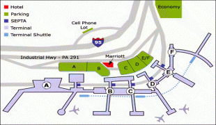
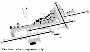
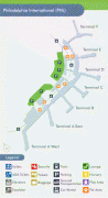
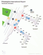
Map - Philadelphia International Airport (Philadelphia International Airport)
Map


Country - United_States
 |
 |
| Flag of the United States | |
Indigenous peoples have inhabited the Americas for thousands of years. Beginning in 1607, British colonization led to the establishment of the Thirteen Colonies in what is now the Eastern United States. They quarreled with the British Crown over taxation and political representation, leading to the American Revolution and proceeding Revolutionary War. The United States declared independence on July 4, 1776, becoming the first nation-state founded on Enlightenment principles of unalienable natural rights, consent of the governed, and liberal democracy. The country began expanding across North America, spanning the continent by 1848. Sectional division surrounding slavery in the Southern United States led to the secession of the Confederate States of America, which fought the remaining states of the Union during the American Civil War (1861–1865). With the Union's victory and preservation, slavery was abolished nationally by the Thirteenth Amendment.
Currency / Language
| ISO | Currency | Symbol | Significant figures |
|---|---|---|---|
| USD | United States dollar | $ | 2 |
| ISO | Language |
|---|---|
| EN | English language |
| FR | French language |
| ES | Spanish language |