Preah Vihear Province (Preah Vihear)
The province is named after the temple of Prasat Preah Vihear. The Dângrêk Mountains and the Cambodia/Thailand border are in the north of Preah Vihear province.
Preah Vihear is one of the nine provinces that are part of the Tonle Sap Biosphere Reserve.
On 15 April 2016, Preah Vihear recorded a temperature of 42.6 C, which is the highest temperature to have ever been recorded in Cambodia.
Map - Preah Vihear Province (Preah Vihear)
Map


Country - Khmer_Republic
 |
 |
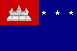
| Flag of Cambodia | |
The main cause of the coup was Norodom Sihanouk's tolerance of North Vietnamese military activity within Cambodia's borders; Vietnamese communist forces had gained de facto control over vast areas of eastern Cambodia as a result. Another important factor was the dire state of the Cambodian economy, an indirect result of Sihanouk's policies of pursuing neutrality.
Currency / Language
| ISO | Currency | Symbol | Significant figures |
|---|---|---|---|
| KHR | Cambodian riel | ៛ | 2 |
| ISO | Language |
|---|---|
| KM | Central Khmer language |
| EN | English language |
| FR | French language |