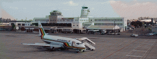
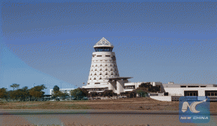
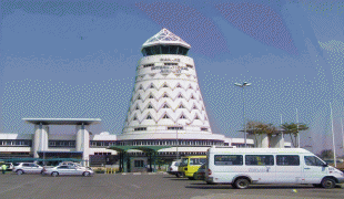
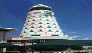
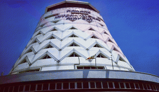
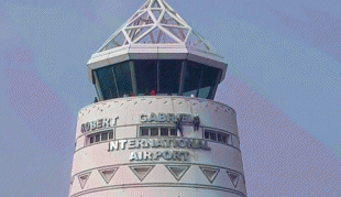
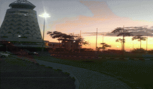
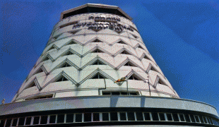
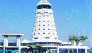
Robert Gabriel Mugabe International Airport (Robert Gabriel Mugabe International Airport)
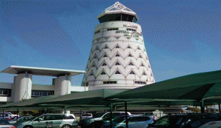
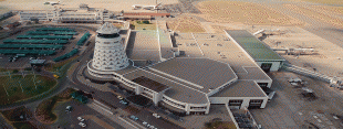
Robert Gabriel Mugabe International Airport, (known colloquially as "RGM", or Mugabe Airport) formerly known as the Harare International Airport, is an international airport in Harare, Zimbabwe. It is the largest airport in the country and serves as the base of Air Zimbabwe. The airport is operated by the Civil Aviation Authority of Zimbabwe. It was originally built as Salisbury Airport.
Commissioned in 1956, and officially opened on 5 February 1957; Salisbury Airport cost £924,000 to build. According to the 1950 report of the Director of Civil Aviation, the city's original aerodrome, Belvedere Airport, had proved to be inadequate and had to be abandoned for the following reasons:
* the runway was some 45° out of alignment, given that approaching aircraft had to enter through a gap in Warren Hills;
* because of the skewed align, aircraft were forced to take-off over the city centre, which posed a real danger of accidents;
* the growing number of high-rise buildings in the city, particularly Milton Building, posed a risk to aircraft;
* Belvedere Airport had been built to accommodate the RAF Elementary Flying Training School, so the layout and design of the buildings were not particularly suitable for commercial aviation.
A site therefore had to be found for the construction of an airport that would be safer and more suitable for commercial activities.
The Southern Rhodesian government had appointed a Southern Rhodesia Aerodrome Board as early as January 1947, whose task was to advise the government on the selection, acquisition, construction and maintenance of government aerodromes and landing grounds in Southern Rhodesia. Later the same year, an Airfield Construction Unit was formed to undertake an extensive search for a suitable site for a national airport.
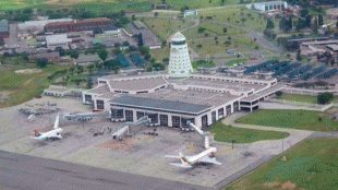
In 1949, the government purchased Kentucky and Adair farms east of Salisbury (2,700 acres at a cost of £54,000) for the construction of the new airport. Also in 1949 the Minister of Mines and Transport set up an Airport Panel to co-ordinate the construction of the airport. The Panel comprised representatives of the interested government departments, the Municipality of Salisbury and Rhodesia Railways.
In 1951 the government announced that the airport would be developed as a joint user aerodrome for both civil aviation and the Southern Rhodesian Air Force (SRAF). Construction of the airport began soon afterwards, and by September 1951, an 8,400 ft runway had been completed, enabling the first aircraft, an SRAF Anson, to land at the new airport.
Commissioned in 1956, and officially opened on 5 February 1957; Salisbury Airport cost £924,000 to build. According to the 1950 report of the Director of Civil Aviation, the city's original aerodrome, Belvedere Airport, had proved to be inadequate and had to be abandoned for the following reasons:
* the runway was some 45° out of alignment, given that approaching aircraft had to enter through a gap in Warren Hills;
* because of the skewed align, aircraft were forced to take-off over the city centre, which posed a real danger of accidents;
* the growing number of high-rise buildings in the city, particularly Milton Building, posed a risk to aircraft;
* Belvedere Airport had been built to accommodate the RAF Elementary Flying Training School, so the layout and design of the buildings were not particularly suitable for commercial aviation.
A site therefore had to be found for the construction of an airport that would be safer and more suitable for commercial activities.
The Southern Rhodesian government had appointed a Southern Rhodesia Aerodrome Board as early as January 1947, whose task was to advise the government on the selection, acquisition, construction and maintenance of government aerodromes and landing grounds in Southern Rhodesia. Later the same year, an Airfield Construction Unit was formed to undertake an extensive search for a suitable site for a national airport.
In 1949, the government purchased Kentucky and Adair farms east of Salisbury (2,700 acres at a cost of £54,000) for the construction of the new airport. Also in 1949 the Minister of Mines and Transport set up an Airport Panel to co-ordinate the construction of the airport. The Panel comprised representatives of the interested government departments, the Municipality of Salisbury and Rhodesia Railways.
In 1951 the government announced that the airport would be developed as a joint user aerodrome for both civil aviation and the Southern Rhodesian Air Force (SRAF). Construction of the airport began soon afterwards, and by September 1951, an 8,400 ft runway had been completed, enabling the first aircraft, an SRAF Anson, to land at the new airport.
Map - Robert Gabriel Mugabe International Airport (Robert Gabriel Mugabe International Airport)


Country - Zimbabwe
 |
 |
| Flag of Zimbabwe | |
The British South Africa Company of Cecil Rhodes demarcated the Rhodesia region in 1890 when they conquered Mashonaland and later in 1893 Matabeleland after a fierce resistance by Matabele people known as the First Matabele War. Company rule ended in 1923 with the establishment of Southern Rhodesia as a self-governing British colony. In 1965, the white minority government unilaterally declared independence as Rhodesia. The state endured international isolation and a 15-year guerrilla war with black nationalist forces; this culminated in a peace agreement that established universal enfranchisement and de jure sovereignty as Zimbabwe in April 1980. Zimbabwe then joined the Commonwealth of Nations, from which it was suspended in 2002 for breaches of international law by its government under Robert Mugabe and from which it withdrew in December 2003.
Currency / Language
| ISO | Currency | Symbol | Significant figures |
|---|---|---|---|
| ZWL | Zimbabwean dollar | 2 |
| ISO | Language |
|---|---|
| SN | Shona language |