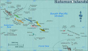
Solomon Islands (Solomon Islands)
 |
 |
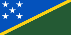
| Flag of the Solomon Islands | |
The islands have been settled since at least some time between 30,000 and 28,800 BCE, with later waves of migrants, notably the Lapita people, mixing and producing the modern indigenous Solomon Islanders population. In 1568, the Spanish navigator Álvaro de Mendaña was the first European to visit them. Though not named by Mendaña, it is believed that the islands were called "the Solomons" by those who later received word of his voyage and mapped his discovery. Mendaña returned decades later, in 1595, and another Spanish expedition, led by Portuguese navigator Pedro Fernandes de Queirós, visited the Solomons in 1606. Britain defined its area of interest in the Solomon Islands archipelago in June 1893, when Captain Gibson, R.N., of HMS Curacoa (1878), declared the southern Solomon Islands a British protectorate. During World War II, the Solomon Islands campaign (1942–1945) saw fierce fighting between the United States, British Commonwealth forces and the Empire of Japan, including the Battle of Guadalcanal.
The official name of the then-British administration was changed from the "British Solomon Islands Protectorate" to "The Solomon Islands" in 1975, and self-government was achieved the following year. Independence was obtained, and the name changed to just "Solomon Islands" (without the definite article), in 1978. At independence, Solomon Islands became a constitutional monarchy. The King of Solomon Islands is Charles III, who is represented in the country by a governor-general.
In 1568, the Spanish navigator Álvaro de Mendaña was the first European to visit the Solomon Islands archipelago but did not name the archipelago at that time, only certain individual islands. Though not named by Mendaña, the islands were subsequently referred to as Islas Salomón (Solomon Islands) by others following reports of his voyage optimistically conflated with stories of the wealthy biblical King Solomon, believing them to be the Bible-mentioned city of Ophir. During most of the colonial period, the territory's official name was the "British Solomon Islands Protectorate" until independence in 1978, when it was changed to "Solomon Islands" as defined in the Constitution of Solomon Islands and as a Commonwealth realm under this name. The definite article, "the", is not part of the country's official name but remains for all references to the area pre-independence and is sometimes used, both within and outside the country. Colloquially the islands are referred to simply as "the Solomons".
Currency / Language
| ISO | Currency | Symbol | Significant figures |
|---|---|---|---|
| SBD | Solomon Islands dollar | $ | 2 |
| ISO | Language |
|---|---|
| EN | English language |