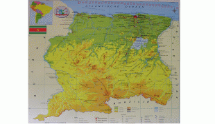
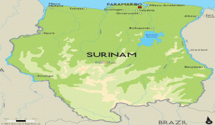
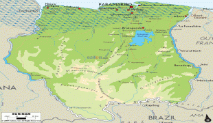
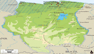
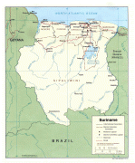
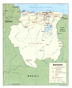
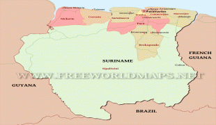
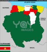
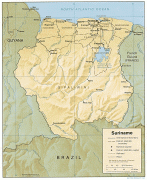
Suriname (Republic of Suriname)
 |
 |
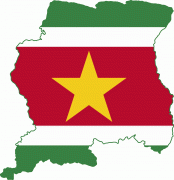
| Flag of Suriname | |
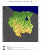
It has a population of approximately, dominated by descendants from the slaves and labourers brought in from Africa and Asia by the Dutch Empire and Republic. Most of the people live by the country's (north) coast, in and around its capital and largest city, Paramaribo. It is also one of the least densely populated countries on Earth. Situated slightly north of the equator, Suriname is a tropical country covered in rainforests. Its extensive tree cover is vital to the country's efforts to mitigate climate change and maintain carbon negativity. A developing country with a relatively high level of human development, Suriname's economy is heavily dependent on its abundant natural resources, namely bauxite, gold, petroleum, and agricultural products.
Suriname was inhabited as early as the fourth millennium BC by various indigenous peoples, including the Arawaks, Caribs, and Wayana. Europeans arrived in the 16th century, with the Dutch establishing control over much of the country's current territory by the late 17th century. During the Dutch colonial period, Suriname was a lucrative source of sugar, its plantation economy driven by African slave labour, and after abolition of slavery in 1863, by indentured servants from Asia, predominantly from British India, as well as the Dutch East Indies. In 1954, Suriname became one of the constituent countries of the Kingdom of the Netherlands. On 25 November 1975, it left the Kingdom to become an independent state. In contrast to Indonesia's earlier war for independence from the Netherlands, the path toward Suriname's independence was an initiative of the then left-wing Dutch government. Suriname continues to maintain close diplomatic, economic, and cultural ties with the Netherlands.
Suriname is considered a culturally Caribbean country, and is a member of the Caribbean Community (CARICOM). It is the only sovereign nation outside of Europe where Dutch is the official and prevailing language of government, business, media, and education. According to research by the Dutch Language Union, Dutch is the native language of 60% of Surinamese. Sranan Tongo, an English-based creole language, is a widely used lingua franca.
Suriname is part of several major international and intergovernmental institutions or groupings including the United Nations and the Organisation of Islamic Cooperation.
The name Suriname may derive from an indigenous people called Surinen, who inhabited the area at the time of European contact. The suffix -ame, common in Surinamese river and place names (see also the Coppename River), may come from aima or eima, meaning river or creek mouth, in Lokono, an Arawak language spoken in the country.
The earliest European sources give variants of "Suriname" as the name of the river on which colonies were eventually founded. Lawrence Kemys wrote in his Relation of the Second Voyage to Guiana of passing a river called "Shurinama" as he travelled along the coast. In 1598, a fleet of three Dutch ships visiting the Wild Coast mention passing the river "Surinamo". In 1617, a Dutch notary spelled the name of the river on which a Dutch trading post had existed three years earlier as "Surrenant".
British settlers, who in 1630 founded the first European colony at Marshall's Creek along the Suriname River, spelled the name as "Surinam"; this would long remain the standard spelling in English. The Dutch navigator David Pietersz. de Vries wrote of travelling up the "Sername" river in 1634 until he encountered the English colony there; the terminal vowel remained in future Dutch spellings and pronunciations. In 1640, a Spanish manuscript entitled "General Description of All His Majesty's Dominions in America" called the river "Soronama". In 1653, instructions given to a British fleet sailing to meet Lord Willoughby in Barbados, which at the time was the seat of English colonial government in the region, again spelled the name of the colony "Surinam". A 1663 royal charter said the region around the river was "called Serrinam also Surrinam".
As a result of the "Surrinam" spelling, 19th-century British sources offered the folk etymology "Surryham", saying it was the name given to the Suriname River by Lord Willoughby in the 1660s in honour of the Duke of Norfolk and Earl of Surrey when an English colony was established under a grant from King Charles II. This folk etymology can be found repeated in later English-language sources.
When the territory was taken over by the Dutch, it became part of a group of colonies known as Dutch Guiana. The official spelling of the country's English name was changed from "Surinam" to "Suriname" in January 1978, but "Surinam" can still be found in English, such as Suriname's national airline Surinam Airways. The older English name is reflected in the English pronunciation,. In Dutch, the official language of Suriname, the pronunciation is, with the main stress on the third syllable and a schwa terminal vowel.
Currency / Language
| ISO | Currency | Symbol | Significant figures |
|---|---|---|---|
| SRD | Surinamese dollar | $ | 2 |
| ISO | Language |
|---|---|
| NL | Dutch language |
| EN | English language |
| JV | Javanese language |