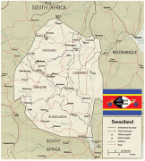
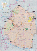
Swaziland (Eswatini)
 |
 |
| Flag of Eswatini | |
The population is composed primarily of ethnic Swazis. The prevalent language is Swazi (siSwati in native form). The Swazis established their kingdom in the mid-18th century under the leadership of Ngwane III. The country and the Swazi take their names from Mswati II, the 19th-century king under whose rule the country was expanded and unified; its boundaries were drawn up in 1881 in the midst of the Scramble for Africa. After the Second Boer War, the kingdom, under the name of Swaziland, was a British high commission territory from 1903 until it regained its full independence on 6 September 1968. In April 2018, the official name was changed from Kingdom of Swaziland to Kingdom of Eswatini, mirroring the name commonly used in Swazi.
Eswatini is a developing country and is classified as a lower-middle income economy. As a member of the Southern African Customs Union and the Common Market for Eastern and Southern Africa, its main local trading partner is South Africa; to ensure economic stability, Eswatini's currency, the lilangeni, is pegged to the South African rand. Eswatini's major overseas trading partners are the United States and the European Union. The majority of the country's employment is provided by its agricultural and manufacturing sectors. Eswatini is a member of the Southern African Development Community, the African Union, the Commonwealth of Nations, and the United Nations.
The government is an absolute monarchy, the last of its kind in Africa, and has been ruled by King Mswati III since 1986. Elections are held every five years to determine the House of Assembly and the Senate majority. Its constitution was adopted in 2005. Umhlanga, the reed dance held in August/September, and incwala, the kingship dance held in December/January, are the nation's most important events. The Swazi population faces major health issues: HIV/AIDS and (to a lesser extent) tuberculosis are widespread. 28% of the adult population is HIV-positive. As of 2018, Eswatini has the 12th-lowest life expectancy in the world, at 58 years. The population of Eswatini is young. As of 2018, people aged 14 years or younger constitute 35% of the country's population and the median age is 22 years.
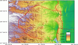
Artefacts have been found indicating human activity dating back to the early Stone Age, around 200,000 years ago. Prehistoric rock art paintings dating from as far back as c. 27,000 years ago to as recently as the 19th century can be found around the country.
The earliest known inhabitants of the region were Khoisan hunter-gatherers. They were largely replaced by the Nguni during the great Bantu migrations. These peoples originated from the Great Lakes region of eastern and central Africa. Evidence of agriculture and iron use dates from about the 4th century. People speaking languages ancestral to the current Sotho and Nguni languages began settling no later than the 11th century.
Currency / Language
| ISO | Currency | Symbol | Significant figures |
|---|---|---|---|
| SZL | Swazi lilangeni | L | 2 |
| ISO | Language |
|---|---|
| EN | English language |
| SS | Swati language |