Tivat Airport (Tivat Airport)
Tivat Airport is an international airport serving the Montenegrin coastal town of Tivat and the surrounding region.
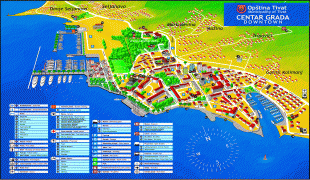
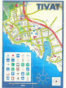
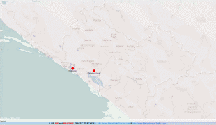
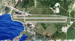
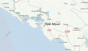
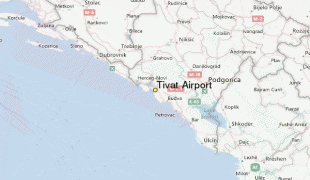
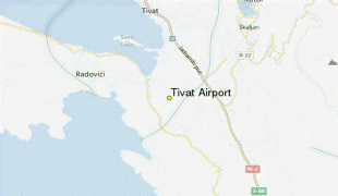
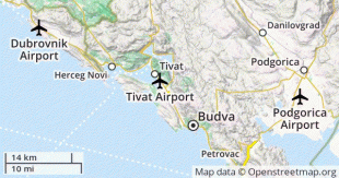
The airport is situated 3 km south of the centre of Tivat, with the runway aligned with the Tivat Field.
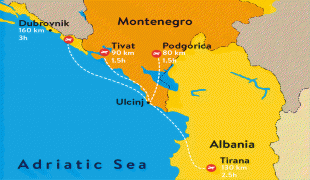
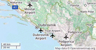
It is the busier of two international airports in Montenegro, the other being Podgorica Airport. Traffic at the airport follows the highly seasonal nature of the tourism industry in coastal Montenegro, with 80% of the total volume of passengers being handled during the peak season (May–September).
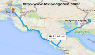
Tivat airport is located right next to the city of Tivat, 8 km from the center of Kotor, and 20 km north-west of Budva, one of the most popular tourist destinations on the eastern Adriatic coast. The sole runway of the airport ends just 88 m from the coastline of the Bay of Kotor.
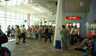
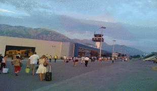
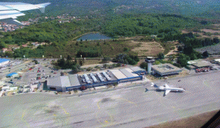
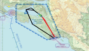
Tivat Airport is assigned 4D classification by ICAO, airspace class D, and is noted for its challenging approach and landing procedures. Landing at Tivat is considered demanding due to the hilly terrain surrounding the valley in which the airport is situated, and strong prevailing crosswinds. Runway 32 approach requires a descent into the valley of Tivatsko polje, and a 20° turn for runway alignment just before landing. Runway 14 approach is even more challenging, because of the circle-to-land maneuver executed in the dramatic scenery surrounding the Bay of Kotor. It is known among pilots as the European Kai Tak because of its tricky approach and landing procedures, and also can be compared to Madeira Airport. Passengers landing at Tivat have views of the bay, the surrounding mountains and a low flyby over Porto Montenegro luxury yacht marina. The airport is commonly visited by plane spotters, as the end of the runway is easily accessible and offers unobstructed views of takeoffs and landings, with a mountain backdrop.
Year-round services from the airport include Belgrade and Moscow; however, more than 80% of the traffic is concentrated in the summer period, with the introduction of seasonal and charter flights. With the opening of Porto Montenegro and the introduction of other high-end tourist services, the airport increasingly caters to business jets.
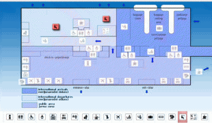
Adriatic Highway (E65/E80) passes right by the passenger terminal, making the airport easily accessible from the entire northern part of Montenegrin coast.
The airport is situated 3 km south of the centre of Tivat, with the runway aligned with the Tivat Field.
It is the busier of two international airports in Montenegro, the other being Podgorica Airport. Traffic at the airport follows the highly seasonal nature of the tourism industry in coastal Montenegro, with 80% of the total volume of passengers being handled during the peak season (May–September).
Tivat airport is located right next to the city of Tivat, 8 km from the center of Kotor, and 20 km north-west of Budva, one of the most popular tourist destinations on the eastern Adriatic coast. The sole runway of the airport ends just 88 m from the coastline of the Bay of Kotor.
Tivat Airport is assigned 4D classification by ICAO, airspace class D, and is noted for its challenging approach and landing procedures. Landing at Tivat is considered demanding due to the hilly terrain surrounding the valley in which the airport is situated, and strong prevailing crosswinds. Runway 32 approach requires a descent into the valley of Tivatsko polje, and a 20° turn for runway alignment just before landing. Runway 14 approach is even more challenging, because of the circle-to-land maneuver executed in the dramatic scenery surrounding the Bay of Kotor. It is known among pilots as the European Kai Tak because of its tricky approach and landing procedures, and also can be compared to Madeira Airport. Passengers landing at Tivat have views of the bay, the surrounding mountains and a low flyby over Porto Montenegro luxury yacht marina. The airport is commonly visited by plane spotters, as the end of the runway is easily accessible and offers unobstructed views of takeoffs and landings, with a mountain backdrop.
Year-round services from the airport include Belgrade and Moscow; however, more than 80% of the traffic is concentrated in the summer period, with the introduction of seasonal and charter flights. With the opening of Porto Montenegro and the introduction of other high-end tourist services, the airport increasingly caters to business jets.
Adriatic Highway (E65/E80) passes right by the passenger terminal, making the airport easily accessible from the entire northern part of Montenegrin coast.
| IATA Code | TIV | ICAO Code | LYTV | FAA Code | |
|---|---|---|---|---|---|
| Telephone | Fax | ||||
| Home page | Hyperlink |
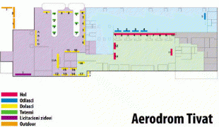
Map - Tivat Airport (Tivat Airport)
Map


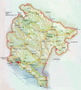
Country - Montenegro
 |
 |
| Flag of Montenegro | |
During the Early Medieval period, three principalities were located on the territory of modern-day Montenegro: Duklja, roughly corresponding to the southern half; Travunia, the west; and Rascia proper, the north. The Principality of Zeta emerged in the 14th and 15th centuries. From the late 14th century to the late 18th century, large parts of southern Montenegro were ruled by the Venetian Republic and incorporated into Venetian Albania. The name Montenegro was first used to refer to the country in the late 15th century. After falling under Ottoman Empire rule, Montenegro gained its semi-autonomy in 1696 under the rule of the House of Petrović-Njegoš, first as a theocracy and later as a secular principality. Montenegro's independence was recognised by the Great Powers at the Congress of Berlin in 1878. In 1910, the country became a kingdom.
Currency / Language
| ISO | Currency | Symbol | Significant figures |
|---|---|---|---|
| EUR | Euro | € | 2 |
| ISO | Language |
|---|---|
| SQ | Albanian language |
| BS | Bosnian language |
| HR | Croatian language |
| HU | Hungarian language |
| SR | Serbian language |