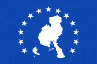
Veraguas Province (Provincia de Veraguas)
 |
Veraguas was originally inhabited by the Veraguas culture.
Veraguas was explored by Christopher Columbus on his fourth voyage. He tried to establish the first colony in the new Spanish mainland but failed due to resistance from Indigenous peoples. Diego de Nicuesa also tried to establish a colony and failed, which made him create a colony to fight against the Indigenous population, which he named Nombre de Dios. Its capital, Santiago de Veraguas, was founded about 1636.
It is said that its name comes from the indigenous word "Veracua" or "Viragua", though other theories abound. It is the only province in Panama with coastlines on both the Caribbean Sea and the Pacific Ocean. The majority of people live on the Pacific side; the Caribbean coast is mostly uninhabited.
Map - Veraguas Province (Provincia de Veraguas)
Map


Country - Panama
 |
 |
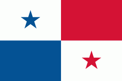
| Flag of Panama | |
Panama was inhabited by indigenous tribes before Spanish colonists arrived in the 16th century. It broke away from Spain in 1821 and joined the Republic of Gran Colombia, a union of Nueva Granada, Ecuador, and Venezuela. After Gran Colombia dissolved in 1831, Panama and Nueva Granada eventually became the Republic of Colombia. With the backing of the United States, Panama seceded from Colombia in 1903, allowing the construction of the Panama Canal to be completed by the United States Army Corps of Engineers between 1904 and 1914. The 1977 Torrijos–Carter Treaties agreed to transfer the canal from the United States to Panama on December 31, 1999. The surrounding territory was first returned in 1979.
Currency / Language
| ISO | Currency | Symbol | Significant figures |
|---|---|---|---|
| PAB | Panamanian balboa | B/ | 2 |
| USD | United States dollar | $ | 2 |
| ISO | Language |
|---|---|
| EN | English language |
| ES | Spanish language |