Flag of Mauritius
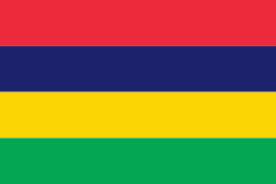
The national flag of Mauritius, also known as the Four Bands and Les Quatre Bandes (French for "the four bands"), was adopted upon independence, March 12, 1968. It consists of four horizontal bands of equal width, coloured (from top to bottom) red, blue, yellow, and green. The flag was recorded at the College of Arms in London on 9 January 1968.
The flag was designed by Gurudutt Moher whose contribution was recognised posthumously in March 2018 in the form of the national title Member of the Star and Key of the Indian Ocean (MSK). Moher, who was a retired school teacher, died of a heart attack on October 7, 2017, at the age of 93.
The civil ensign (for private vessels) and government ensign (for state vessels) are red and blue flags, respectively, each with the national flag in the canton and the coat of arms of Mauritius in the fly.
The naval ensign (used by coast guard vessels) is an unusual design consisting of red, white, and blue vertical stripes of unequal widths defaced by a central anchor/key emblem.
The flag of Mauritius consists of red, blue, yellow and green bands which officially stand for:
* Red represents the struggle for freedom and independence.
* Blue represents the Indian Ocean, in which Mauritius is situated.
* Yellow represents the light of freedom shining over the island.
* Green represents the agriculture of Mauritius and its colour throughout the 12 months of the year.
In an attempt to unite the nation, especially following the deadly and divisive riots of 1965 and those of 1968, the colours also have political origins. Indeed, the colours also represent the main political parties which existed at the time, namely:
National flag
Country - Mauritius
Warning: getimagesize(/Image/Map/MP934292.gif): failed to open stream: No such file or directory in /home/mapnlee7/public_html/MAPNALL/article.php on line 532
 |
 |
Arab sailors were the first to discover the uninhabited island, around 975, and they called it Dina Arobi. In 1507, Portuguese sailors visited the uninhabited island. The island appears with the Portuguese names Cirne or Do-Cerne on early Portuguese maps. The Dutch took possession in 1598, establishing a succession of short-lived settlements over a period of about 120 years, before abandoning their efforts in 1710. France took control in 1715, renaming it Isle de France. In 1810, the United Kingdom seized the island, and four years later, in the Treaty of Paris, France ceded Mauritius and its dependencies to the United Kingdom. The British colony of Mauritius included Rodrigues, Agaléga, St. Brandon, the Chagos Archipelago, and, until 1906, the Seychelles. Mauritius and France dispute sovereignty over the island of Tromelin as the Treaty of Paris failed to mention it specifically. Mauritius remained a primarily plantation-based colony of the United Kingdom until independence in 1968.