Arkhangelsk Oblast (Arkhangelsk Oblast)
 |
 |
The city of Arkhangelsk, with a population of 301,199 as of the 2021 Census, is the administrative center of the oblast. The second largest city is the nearby Severodvinsk, home to Sevmash, a major shipyard for the Russian Navy. Among the oldest populated places of the oblast are Kholmogory, Kargopol, and Solvychegodsk; there are a number of Russian Orthodox monasteries, including the Antoniev Siysky Monastery and the World Heritage Site of the Solovetsky Islands in the White Sea.
Plesetsk Cosmodrome is one of three spaceports in Russia (the other two are Kapustin Yar in Astrakhan Oblast and Yasny in Orenburg Oblast).
Arkhangelsk Oblast, which includes the Nenets Autonomous Okrug, borders Kirov Oblast, Vologda Oblast, the Republic of Karelia, the Komi Republic, and the White, Pechora, Barents and Kara seas. Cape Fligely in Franz Josef Land (the northernmost point of Russia, Europe and Eurasia) and Cape Zhelaniya in Novaya Zemlya (the easternmost point of Europe) are both located within Arkhangelsk Oblast. Mount Kruzenshtern is the highest point of the oblast.
Arkhangelsk Oblast is located on the East European Plain, and most of it represents forested hilly landscape. The north-eastern part belongs to the Timan Ridge, a highland mostly situated east from the oblast. The Nenets Autonomous Okrug is essentially a flat tundra (Bolshezemelskaya Tundra) with several hill chains like Pay-Khoy Ridge. The Arctic islands including Novaya Zemlya and Franz Joseph Land are mountainous with glaciers and eternally snow-covered. This region has a genetically distinct population of polar bears associated with the Barents Sea area.
Almost all of the area of the Oblast belongs to the basin of the Arctic Ocean, with the major rivers being the (from west to east) Onega River, the Northern Dvina (with the major tributaries the Vychegda, the Vaga, and the Pinega), Kuloy River, Mezen River, and Pechora Rivers. A minor area in the west of the Oblast, most notably the basin of the Ileksa River, drains into the Lake Onega and eventually to the Baltic Sea. A very minor area in Kargopolsky District in the south-west of the Oblast drains into the Kema River which belongs to the basin of the Caspian Sea. The area in the Onega River basin containing the biggest lakes in the oblast, such as Lake Lacha, Lake Kenozero, Lake Undozero, and Lake Kozhozero. The tundra of the Nenets Autonomous Okrug also contains a number of bigger lakes. The river basin of the Pinega is characteristic of the karst, with a number of caves in the region.
The White Sea coast within the Oblast is split into the Onega Bay (where the Onega is the major tributary), the Dvina Bay (the Northern Dvina), and the Mezen Bay (comprising the Mezen and the Kuloy). The Solovetsky Islands, as well as a number of smaller islands, are located in Onega Bay. Onega Bay and the Dvina Bay are separated by the Onega Peninsula. The Mezen Bay is separated from the main body of the White Sea by Morzhovets Island. Other major islands in the oblast include Shogly, Zhizgin, Yagry, Lyasomin, Layda, Nikolskiy, and Mudyugskiy islands.
Almost all of the oblast is covered by taiga, the coniferous forest dominated by pine, spruce, and larch. Large areas in the middle of taiga are devoid of trees and covered by swamps. In the floodplains of the rivers, there are meadows.
A number of areas in Arkhangelsk Oblast have been designated as protected natural areas. These are subdivided into national parks, nature reserves (zapovedniks), and zakazniks of the federal level. The following protected areas have been designated,
* Kenozersky National Park;
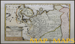
Map - Arkhangelsk Oblast (Arkhangelsk Oblast)
Map


Country - Russia
 |
 |
| Flag of Russia | |
The East Slavs emerged as a recognisable group in Europe between the 3rd and 8th centuries CE. The first East Slavic state, Kievan Rus', arose in the 9th century, and in 988, it adopted Orthodox Christianity from the Byzantine Empire. Rus' ultimately disintegrated, with the Grand Duchy of Moscow growing to become the Tsardom of Russia. By the early 18th century, Russia had vastly expanded through conquest, annexation, and the efforts of Russian explorers, developing into the Russian Empire, which remains the third-largest empire in history. However, with the Russian Revolution in 1917, Russia's monarchic rule was abolished and replaced by the Russian SFSR—the world's first constitutionally socialist state. Following the Russian Civil War, the Russian SFSR established the Soviet Union (with three other Soviet republics), within which it was the largest and principal constituent. At the expense of millions of lives, the Soviet Union underwent rapid industrialization in the 1930s, and later played a decisive role for the Allies of World War II by leading large-scale efforts on the Eastern Front. With the onset of the Cold War, it competed with the United States for global ideological influence; the Soviet era of the 20th century saw some of the most significant Russian technological achievements, including the first human-made satellite and the first human expedition into outer space.
Currency / Language
| ISO | Currency | Symbol | Significant figures |
|---|---|---|---|
| RUB | Russian ruble | ₽ | 2 |
| ISO | Language |
|---|---|
| CE | Chechen language |
| CV | Chuvash language |
| KV | Komi language |
| RU | Russian language |
| TT | Tatar language |


