Banteay Meanchey Province (Banteay Meanchey)
Banteay Meanchey is the 13th largest province in Cambodia. With a population of 861,883, it ranks as the ninth most populous in the nation. The city of Poipet in the western part of the province is an international border crossing into Thailand. Banteay Meanchey is one of the nine provinces that are part of the Tonlé Sap Biosphere Reserve.
Banteay Meanchey means "fortress of victory" in Khmer. The word -chey (ជ័យ) is derived from the Sanskrit word jaya (जय) meaning "victory" with mean- (មាន) means to have, so the combination of both literally means to have victory and banteay (បន្ទាយ) is a Khmer word meaning "fortress" or "castle".
Map - Banteay Meanchey Province (Banteay Meanchey)
Map


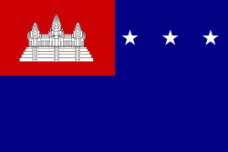
Country - Khmer_Republic
 |
 |
| Flag of Cambodia | |
The main cause of the coup was Norodom Sihanouk's tolerance of North Vietnamese military activity within Cambodia's borders; Vietnamese communist forces had gained de facto control over vast areas of eastern Cambodia as a result. Another important factor was the dire state of the Cambodian economy, an indirect result of Sihanouk's policies of pursuing neutrality.
Currency / Language
| ISO | Currency | Symbol | Significant figures |
|---|---|---|---|
| KHR | Cambodian riel | ៛ | 2 |
| ISO | Language |
|---|---|
| KM | Central Khmer language |
| EN | English language |
| FR | French language |