Calderdale
 |
Calderdale covers part of the South Pennines, and the Calder Valley is the southernmost of the Yorkshire Dales, though it is not part of the Yorkshire Dales National Park. The borough was formed in 1974 by the merger of six local government districts, from east to west Brighouse, Elland, Halifax, Sowerby Bridge, Hebden Bridge and Todmorden. Mytholmroyd, together with Hebden Bridge, forms Hebden Royd.
Halifax is the commercial, cultural and administrative centre of the borough. Calderdale is served by Calderdale Council, which is headquartered in Halifax, with some functions based in Todmorden.
The Roman settlement of Cambodunum was probably located within Calderdale. A Roman fort has been excavated in Slack, which is in the neighbouring borough of Kirklees, but its identity is not yet certain.
The borough was formed on 1 April 1974, under the Local Government Act 1972, by the merger of the then county borough of Halifax, the boroughs of Brighouse, Todmorden and the urban districts of Elland, Hebden Royd, Ripponden, Sowerby Bridge, part of Queensbury and Shelf urban district and Hepton Rural District.
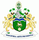
The Coat of arms of Calderdale Metropolitan Borough Council was granted to the new council just a few months after the borough was formed. The Paschal lamb is the emblem of John the Baptist, the patron saint of wool workers. It was shown on the former arms of Halifax. The green and blue wavy line of the shield symbolises the River Calder and Calder Valley. The white rose is for Yorkshire. The crest shows a rose bush with nine white flowers representing the nine former authorities that now comprise the Calderdale district. The bush is shown growing out of a mural crown, a common feature in municipal arms. The lion supporters are taken from the arms of Halifax and also for England. A lion also featured on the shield of the arms of Brighouse. The black crescents, also from the arms of Brighouse, are featured on the arms of the Brighouse family. The blue wave around each lion's collar is from the arms of Todmorden and represents the Calder again. The motto, Industria arte prundentia, is Latin for 'Industry, skill, and foresight'. The formal description, or blazon, of the arms is: "For the arms: Vert a Paschal Lamb proper supporting over the shoulder a Cross Staff Or flying therefrom a forked Pennon of St. George between in chief a Bar wavy Argent charged with a Barruret wavy Azure and in base a Rose Argent barbed and seeded proper; and for the crest: On a Wreath Argent and Vert out of a Mural Crown a Rose Tree of nine branches proper each terminating in a Rose Argent barbed and seeded proper; and for the supporters: On either side a Lion Or gorged with a collar wavy Azure and holding aloft in the interior forepaw a Crescent Sable; Motto: INDUSTRIA ARTE PRUDENTIA."
Map - Calderdale
Map


Country - United_Kingdom
 |
 |
| Flag of the United Kingdom | |
The United Kingdom has evolved from a series of annexations, unions and separations of constituent countries over several hundred years. The Treaty of Union between the Kingdom of England (which included Wales, annexed in 1542) and the Kingdom of Scotland in 1707 formed the Kingdom of Great Britain. Its union in 1801 with the Kingdom of Ireland created the United Kingdom of Great Britain and Ireland. Most of Ireland seceded from the UK in 1922, leaving the present United Kingdom of Great Britain and Northern Ireland, which formally adopted that name in 1927. The nearby Isle of Man, Guernsey and Jersey are not part of the UK, being Crown Dependencies with the British Government responsible for defence and international representation. There are also 14 British Overseas Territories, the last remnants of the British Empire which, at its height in the 1920s, encompassed almost a quarter of the world's landmass and a third of the world's population, and was the largest empire in history. British influence can be observed in the language, culture and the legal and political systems of many of its former colonies.
Currency / Language
| ISO | Currency | Symbol | Significant figures |
|---|---|---|---|
| GBP | Pound sterling | £ | 2 |
| ISO | Language |
|---|---|
| EN | English language |
| GD | Gaelic language |
| CY | Welsh language |