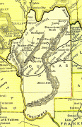
Douglas (Douglas)
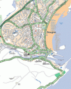
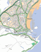
Douglas (Doolish, ) is the capital and largest town of the Isle of Man, with a population of 26,677 (2021). It is located at the mouth of the River Douglas, and on a sweeping bay of 2 mi. The River Douglas forms part of the town's harbour and main commercial port.
Douglas was a small settlement until it grew rapidly as a result of links with the English port of Liverpool in the 18th century. Further population growth came in the following century, resulting during the 1860s in a staged transfer of the High Courts, the Lieutenant Governor's residence, and finally the seat of the legislature, Tynwald, to Douglas from the ancient capital, Castletown.
The town is the Island's main hub for business, finance, legal services, shipping, transport, shopping, and entertainment. The annual Isle of Man TT motorcycle races start and finish in Douglas.
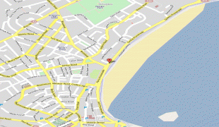
Map - Douglas (Douglas)
Map


Country - Isle_of_Man
 |
 |
Humans have lived on the island since before 6500 BC. Gaelic cultural influence began in the 5th century AD, when Irish missionaries following the teaching of St. Patrick began settling the island, and the Manx language, a branch of the Goidelic languages, emerged. In 627, King Edwin of Northumbria conquered the Isle of Man along with most of Mercia. In the 9th century, Norsemen established the thalassocratic Kingdom of the Isles, which included the Isle of Man. Magnus III, King of Norway from 1093 to 1103, reigned as King of Mann and the Isles between 1099 and 1103.
Currency / Language
| ISO | Currency | Symbol | Significant figures |
|---|---|---|---|
| GBP | Pound sterling | £ | 2 |
| ISO | Language |
|---|---|
| EN | English language |
| GV | Manx language |