Map - Drochia District (Raionul Drochia)

Drochia District (Raionul Drochia)
Drochia district, also known as Drokievsky district, is a district in the north of Moldova. Its administrative center is the city of Drochia. As of 2011, its population was 90,100.

The oldest historical attestations about the settlements in the district from the period 1443 to 1470 when the mentioned villages Cotova, Hasnasenii Mari, Mindic. In the next century of growth followed both economic, cultural and demographic explosion, shown by the fact that 11 villages in the district had 3,000 inhabitants. After the Treaty of Bucharest in 1812, Bessarabia as Drochia district are occupied by the Russian Empire at this time there is a massive colonization by Ukrainians and Russians. In 1918 after the collapse of the Russian Empire, Bessarabia united with the motherland Romania. And in 1940, Bessarabia is again occupied by the USSR on the Molotov-Ribbentrop Treaty. After the 2004 census the population was 94.500 inhabitants of the district.

 
Map - Drochia District (Raionul Drochia)
Map
Openstreetmap - Map - Drochia District
Openstreetmap
Map - Drochia District - Esri.WorldImagery
Esri.WorldImagery
Map - Drochia District - Esri.WorldStreetMap
Esri.WorldStreetMap
Map - Drochia District - OpenStreetMap.Mapnik
OpenStreetMap.Mapnik
Map - Drochia District - OpenStreetMap.HOT
OpenStreetMap.HOT
Map - Drochia District - CartoDB.Positron
CartoDB.Positron
Map - Drochia District - CartoDB.Voyager
CartoDB.Voyager
Map - Drochia District - OpenMapSurfer.Roads
OpenMapSurfer.Roads
Map - Drochia District - Esri.WorldTopoMap
Esri.WorldTopoMap
Map - Drochia District - Stamen.TonerLite
Stamen.TonerLite
Country - Moldova
Flag of Moldova
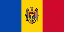
Moldova (, sometimes ; ), officially the Republic of Moldova (Republica Moldova), is a landlocked country in Eastern Europe. It is bordered by Romania to the west and Ukraine to the north, east, and south. The unrecognised state of Transnistria lies across the Dniester river on the country's eastern border with Ukraine. Moldova's capital and largest city is Chișinău.

Most of Moldovan territory was a part of the Principality of Moldavia from the 14th century until 1812, when it was ceded to the Russian Empire by the Ottoman Empire (to which Moldavia was a vassal state) and became known as Bessarabia. In 1856, southern Bessarabia was returned to Moldavia, which three years later united with Wallachia to form Romania, but Russian rule was restored over the whole of the region in 1878. During the 1917 Russian Revolution, Bessarabia briefly became an autonomous state within the Russian Republic. In February 1918, it declared independence and then integrated into Romania later that year following a vote of its assembly. The decision was disputed by Soviet Russia, which in 1924 established, within the Ukrainian SSR, a so-called Moldavian autonomous republic on partially Moldovan-inhabited territories to the east of Bessarabia.
Currency / Language  
ISO Currency Symbol Significant figures
MDL Moldovan leu L 2
Neighbourhood - Country  
  •  Romania 
  •  Ukraine 
Administrative Subdivision
City, Village,...