Map - Gabú

Gabú
Gabu is the largest town in eastern Guinea-Bissau and capital of the Gabu Region.

From 1537, the town was the centre of the eponymous kingdom of Kaabu, also written Ngabou or N’Gabu. Its population was originally a Mandé people from what is currently Mali, and the kingdom was initially vassal to the Mali Empire. As the latter waned, Sama Koli, Gabu's governor, proclaimed himself king, but maintained many of the trappings of Malian cultural heritage. The kingdom built earthen ramparts around the settlement (now vanished) and established trade relations with the Portuguese on the coast.

In the early nineteenth century, the Fula ethnic group converted to Islam and began the Kansala War to end Mandé dominance. It ended with a big fire which caused extensive damage and casualties on both sides. Gabu there after became linked with the Imamate of Futa Jallon and was finally assimilated into the Portuguese Empire. The Portuguese named the town "Nova Lamego" ie "New Lamego", after the Douro town of Lamego. It was renamed Gabu (sometimes spelled Cabu ) after Guinea Bissau's independence.

 
Map - Gabú
Map
Google - Map - Gabú
Google
Google Earth - Map - Gabú
Google Earth
Nokia - Map - Gabú
Nokia
Openstreetmap - Map - Gabú
Openstreetmap
Map - Gabú - Esri.WorldImagery
Esri.WorldImagery
Map - Gabú - Esri.WorldStreetMap
Esri.WorldStreetMap
Map - Gabú - OpenStreetMap.Mapnik
OpenStreetMap.Mapnik
Map - Gabú - OpenStreetMap.HOT
OpenStreetMap.HOT
Map - Gabú - OpenTopoMap
OpenTopoMap
Map - Gabú - CartoDB.Positron
CartoDB.Positron
Map - Gabú - CartoDB.Voyager
CartoDB.Voyager
Map - Gabú - OpenMapSurfer.Roads
OpenMapSurfer.Roads
Map - Gabú - Esri.WorldTopoMap
Esri.WorldTopoMap
Map - Gabú - Stamen.TonerLite
Stamen.TonerLite
Country - Guinea-Bissau
Flag of Guinea-Bissau
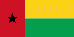
Guinea-Bissau (Guiné-Bissau; ???? ???????; Mandinka: ߖߌߣߍ ߺ ߓߌߛߊߥߏ߫ Gine-Bisawo), officially the Republic of Guinea-Bissau (República da Guiné-Bissau ), is a country in West Africa that covers 36125 km2 with an estimated population of 2,026,778. It borders Senegal to its north and Guinea to its southeast. Guinea-Bissau is the only Portuguese-speaking country in which Islam is the predominant religion.

Guinea-Bissau was once part of the kingdom of Kaabu, as well as part of the Mali Empire. Parts of this kingdom persisted until the 18th century, while a few others were under some rule by the Portuguese Empire since the 16th century. In the 19th century, it was colonised as Portuguese Guinea. Portuguese control was restricted and weak until the early 20th century with the pacification campaigns, these campaigns solidified Portuguese sovereignty in the area. The final Portuguese victory over the remaining bastion of mainland resistance, the Papel ruled Kingdom of Bissau in 1915 by the Portuguese military office Teixeira Pinto, and recruited Wolof mercenary Abdul Injai was the event to solidify mainland control. The Bissagos, islands off the coast of Guinea-Bissau, were officially conquered in 1936, ensuring Portuguese control of both the mainland and islands of the region. Upon independence, declared in 1973 and recognised in 1974, the name of its capital, Bissau, was added to the country's name to prevent confusion with Guinea (formerly French Guinea). Guinea-Bissau has a history of political instability since independence, and only one elected president (José Mário Vaz) has successfully served a full five-year term. The current president is Umaro Sissoco Embaló, who was elected on 29 December 2019.
Currency / Language  
ISO Currency Symbol Significant figures
XOF West African CFA franc Fr 0
ISO Language
PT Portuguese language
Neighbourhood - Country  
  •  Guinea 
  •  Senegal