Hurghada International Airport (Hurghada International Airport)
Hurghada International Airport is the international airport of Hurghada in Egypt. It is located inland, 5 km southwest of El Dahar, the downtown of Hurghada. It is the second busiest airport in Egypt after Cairo International Airport and an important destination for leisure flights mainly from Europe.
The airport currently has two passenger terminals: Terminal 1 and Terminal 2. Construction of the new terminal complex cost $335 million, which was mainly financed by the Arab Fund for Economic Development. Egypt's aviation minister, Houssam Kamal, said that the airport would be able to host up to 13 million visitors annually. The project was inaugurated by President Abdel Fattah el-Sisi on December 17, 2014. The new terminal has a total area of 92,000 square meters on three levels. The departure hall has 72 check-in counters and 20 departure gates.
The airport currently has two passenger terminals: Terminal 1 and Terminal 2. Construction of the new terminal complex cost $335 million, which was mainly financed by the Arab Fund for Economic Development. Egypt's aviation minister, Houssam Kamal, said that the airport would be able to host up to 13 million visitors annually. The project was inaugurated by President Abdel Fattah el-Sisi on December 17, 2014. The new terminal has a total area of 92,000 square meters on three levels. The departure hall has 72 check-in counters and 20 departure gates.
| IATA Code | HRG | ICAO Code | HEGN | FAA Code | |
|---|---|---|---|---|---|
| Telephone | Fax | ||||
| Home page |
Map - Hurghada International Airport (Hurghada International Airport)
Map


Country - United_Arab_Republic
 |
 |
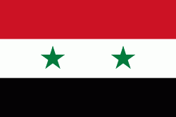
| Flag of Egypt | |
The republic was led by Egyptian President Gamal Abdel Nasser. The UAR was a member of the United Arab States, a loose confederation with the Mutawakkilite Kingdom of Yemen, which was dissolved in 1961.
Currency / Language
| ISO | Currency | Symbol | Significant figures |
|---|---|---|---|
| EGP | Egyptian pound | £ or جم | 2 |
| ISO | Language |
|---|---|
| AR | Arabic language |
| EN | English language |
| FR | French language |