Il-Fgura
Fgura (Il-Fgura, Figura) is a town in the South Eastern Region of Malta. It has a population of 13,066 as of 2021. Its northern fringes are bordered by the Cottonera Lines of fortifications while it merges with the towns of Żabbar to the east and Paola and Tarxien to the West. A modern settlement, Fgura expanded to the outskirts of the Grand Harbour area and was one of the fastest-growing towns of Malta. Fgura has grown to become one of the foremost commercial areas in the central-southern part of the island. Today, Fgura has one of the highest population densities in the country.
The name Fgura comes from the surname of the Ficura family who owner land and lived in the area when it was a rural village.
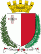
The coat-of-arms of Fgura is made up of a red horizontal stripe containing three golden 5-pointed stars, centred across a white background. Fgura Day was established by the local council in 1994, and its first celebration was held on 30 October. It is now celebrated on the last Sunday of October.
The patron saint of Fgura is Our Lady of Mount Carmel and an annual feast in her honour is celebrated on the second Sunday of July. Fgura also has one of the most peculiar shaped churches in Malta, built in the shape of a tent.
The name Fgura comes from the surname of the Ficura family who owner land and lived in the area when it was a rural village.
The coat-of-arms of Fgura is made up of a red horizontal stripe containing three golden 5-pointed stars, centred across a white background. Fgura Day was established by the local council in 1994, and its first celebration was held on 30 October. It is now celebrated on the last Sunday of October.
The patron saint of Fgura is Our Lady of Mount Carmel and an annual feast in her honour is celebrated on the second Sunday of July. Fgura also has one of the most peculiar shaped churches in Malta, built in the shape of a tent.
Map - Il-Fgura
Map


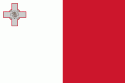
Country - Malta
 |
 |
| Flag of Malta | |
Malta has been inhabited since approximately 5900 BC. Its location in the centre of the Mediterranean has historically given it great strategic importance as a naval base, with a succession of powers having contested and ruled the islands, including the Phoenicians and Carthaginians, Romans, Greeks, Arabs, Normans, Aragonese, Knights of St. John, French, and British, amongst others.
Currency / Language
| ISO | Currency | Symbol | Significant figures |
|---|---|---|---|
| EUR | Euro | € | 2 |
| ISO | Language |
|---|---|
| EN | English language |
| MT | Maltese language |
