Is-Swieqi
 |
 |
It has an estimated population of 14,452 as of 1 January 2019.
The area's quiet environment and central location have made it popular with the upper-middle/high class population of the island. Vacant property in this area is scarce. Swieqi has seen its population rise over the years. It accommodated 8,099 people as of November 2005; a small number of service industries, IT facilities and English language schools have taken root.
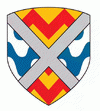
The municipality of Swieqi assimilates Swieqi, Tal-Ibraġ, Madliena and part of St. Andrews. Madliena and St. Andrew's originally formed part of Ħal Għargħur. The hamlet of Madliena owes its origin to the Chapel of St. Mary Magdalen, which was built in the 15th century. Tal-Ibraġ is a newly developed hamlet which, over the past decade, has almost reached its maximum development potential. St. Andrew's is on the outskirts of Swieqi at the border with the locality of Pembroke. The town's coat of arms features a red and gold zig-zag motif indicating the valleys and fields of Tal-Ibraġ, blue waves indicating the watering courses (swieqi in Maltese) and a silver saltire. Madliena is indicated with the red letter M. Swieqi has its own local council, and in 2007 it had its own postal code instated (SWQ....). The town fell under the jurisdiction of St. Julian's, Birkirkara, San Ġwann, Naxxar and Ħal Għargħur at different times in its history.
Map - Is-Swieqi
Map
Country - Malta
 |
 |
| Flag of Malta | |
Malta has been inhabited since approximately 5900 BC. Its location in the centre of the Mediterranean has historically given it great strategic importance as a naval base, with a succession of powers having contested and ruled the islands, including the Phoenicians and Carthaginians, Romans, Greeks, Arabs, Normans, Aragonese, Knights of St. John, French, and British, amongst others.
Currency / Language
| ISO | Currency | Symbol | Significant figures |
|---|---|---|---|
| EUR | Euro | € | 2 |
| ISO | Language |
|---|---|
| EN | English language |
| MT | Maltese language |


