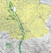
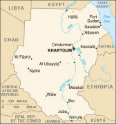
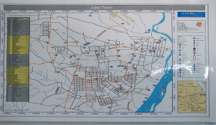
Juba (Juba)
Juba is the capital and largest city of South Sudan. The city is situated on the White Nile and also serves as the capital of the Central Equatoria State. It is the world's newest capital city to be elevated as such, and had a population of 525,953 in 2017. It has an area of 52 sqkm, with the metropolitan area covering 336 sqkm.
Juba was established in 1920–21 by the Church Missionary Society (CMS) in a small Bari village, also called Juba. The city was made as the capital of Mongalla Province in the late 1920s. The growth of the town accelerated following the signing of the Comprehensive Peace Agreement in 2005, which made Juba the capital of the Autonomous Government of Southern Sudan. Juba became the capital of South Sudan in 2011 after its independence, but influential parties wanted Ramciel to be the capital. The government announced the move of the capital to Ramciel, but it is yet to occur.
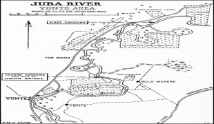
Under the Khedivate of Egypt, Juba served as the southernmost garrison of the Egyptian army, quartering only a handful of soldiers. Disease was common; soldiers often fell ill due to the malaria, meningitis and blackwater fever that was prevalent in the region. Explorers and campaigners (Sir) Samuel and Florence Baker used the nearby island of Gondokoro as a base during their expeditions to what is now South Sudan and northern Uganda from 1863 to 1865 and 1871 to 1873.
The present city of Juba was established on the site of a small Bari village, also called Juba, where the Church Missionary Society (CMS) had established a mission and the Nugent Memorial Intermediate School in 1920–21. In the late 1920s, Anglo-Egyptian officials ordered Bari residents to relocate so that a new town could be constructed to serve as the capital of Mongalla Province. The site was chosen by Anglo-Egyptian officials partly because of the presence of the CMS Nugent Memorial Intermediate School there, and partly because its proximity to river transportation on the Nile. Major construction of the new city of Juba was underway by 1927. Traders from Rejaf relocated to the new city in 1929, and the Governor's office of Mongalla was moved there in 1930.
Greek merchants supplying the British Army played an early and central role in the establishment of Juba in the early 1920s. Their number never exceeded 2,000, but because of their excellent relationship with the native Bari people and the large amount of resulting assistance they received, they built many structures in the downtown Juba Market area as well as in the area which the contemporary British soldiers called the Greek Quarter, today the small suburb of Hai Jalaba. Many of these structures are still standing today. Public buildings such as the Ivory Bank, Notos Lounge, the old Sudan Airways Building, Paradise Hotel, and the Nile Commercial Bank and Buffalo Commercial Bank were all built by Greeks. Greek merchants were responsible for the construction of the Central Bank building in the mid-1940s, as well as the Juba Hotel in the mid-1930s.
Until 1956, Juba was in Anglo-Egyptian Sudan, which was jointly administered by the United Kingdom and the Kingdom of Egypt. British hopes to join the southern part of Sudan with Uganda were dashed in 1947 during the Juba Conference, which resulted in an agreement to unify northern and southern Sudan. In 1955, a mutiny of southern soldiers in Torit sparked the First Sudanese Civil War, which did not end until 1972. During the Second Sudanese Civil War, Juba was a strategic location that was the focus of much fighting.
In 2005, Juba became the interim seat and the capital of the Autonomous Government of Southern Sudan after the signing of the Comprehensive Peace Agreement (before the agreement, Rumbek had been the proposed interim capital). With the advent of peace, the United Nations increased its presence in Juba, shifting its management of operations in Southern Sudan from its previous location in Kenya. Under the leadership of the United Nations Office for the Coordination of Humanitarian Affairs, the United Nations established a camp known as "OCHA Camp", which served as a base for many United Nations agencies and non-governmental organizations.
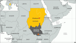
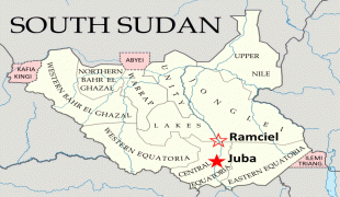
Juba became the world's newest national capital on 9 July 2011, when South Sudan formally declared its independence from the Republic of the Sudan. However, influential parties including the South Sudanese government expressed dissatisfaction with the city's suitability as a national capital, and the government proposed that a new planned city be built as a replacement capital elsewhere, most likely Ramciel in Lakes.
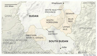
On 5 September 2011, the government announced the capital of South Sudan would move some 250 km away from Juba to Ramciel, which is located in the middle of South Sudan, about 60 km from Yirol West County, Lakes State. As of June 2020, the move has yet to occur.
In September 2015, nearly 200 people were killed in a tanker explosion in Juba.
Juba was established in 1920–21 by the Church Missionary Society (CMS) in a small Bari village, also called Juba. The city was made as the capital of Mongalla Province in the late 1920s. The growth of the town accelerated following the signing of the Comprehensive Peace Agreement in 2005, which made Juba the capital of the Autonomous Government of Southern Sudan. Juba became the capital of South Sudan in 2011 after its independence, but influential parties wanted Ramciel to be the capital. The government announced the move of the capital to Ramciel, but it is yet to occur.
Under the Khedivate of Egypt, Juba served as the southernmost garrison of the Egyptian army, quartering only a handful of soldiers. Disease was common; soldiers often fell ill due to the malaria, meningitis and blackwater fever that was prevalent in the region. Explorers and campaigners (Sir) Samuel and Florence Baker used the nearby island of Gondokoro as a base during their expeditions to what is now South Sudan and northern Uganda from 1863 to 1865 and 1871 to 1873.
The present city of Juba was established on the site of a small Bari village, also called Juba, where the Church Missionary Society (CMS) had established a mission and the Nugent Memorial Intermediate School in 1920–21. In the late 1920s, Anglo-Egyptian officials ordered Bari residents to relocate so that a new town could be constructed to serve as the capital of Mongalla Province. The site was chosen by Anglo-Egyptian officials partly because of the presence of the CMS Nugent Memorial Intermediate School there, and partly because its proximity to river transportation on the Nile. Major construction of the new city of Juba was underway by 1927. Traders from Rejaf relocated to the new city in 1929, and the Governor's office of Mongalla was moved there in 1930.
Greek merchants supplying the British Army played an early and central role in the establishment of Juba in the early 1920s. Their number never exceeded 2,000, but because of their excellent relationship with the native Bari people and the large amount of resulting assistance they received, they built many structures in the downtown Juba Market area as well as in the area which the contemporary British soldiers called the Greek Quarter, today the small suburb of Hai Jalaba. Many of these structures are still standing today. Public buildings such as the Ivory Bank, Notos Lounge, the old Sudan Airways Building, Paradise Hotel, and the Nile Commercial Bank and Buffalo Commercial Bank were all built by Greeks. Greek merchants were responsible for the construction of the Central Bank building in the mid-1940s, as well as the Juba Hotel in the mid-1930s.
Until 1956, Juba was in Anglo-Egyptian Sudan, which was jointly administered by the United Kingdom and the Kingdom of Egypt. British hopes to join the southern part of Sudan with Uganda were dashed in 1947 during the Juba Conference, which resulted in an agreement to unify northern and southern Sudan. In 1955, a mutiny of southern soldiers in Torit sparked the First Sudanese Civil War, which did not end until 1972. During the Second Sudanese Civil War, Juba was a strategic location that was the focus of much fighting.
In 2005, Juba became the interim seat and the capital of the Autonomous Government of Southern Sudan after the signing of the Comprehensive Peace Agreement (before the agreement, Rumbek had been the proposed interim capital). With the advent of peace, the United Nations increased its presence in Juba, shifting its management of operations in Southern Sudan from its previous location in Kenya. Under the leadership of the United Nations Office for the Coordination of Humanitarian Affairs, the United Nations established a camp known as "OCHA Camp", which served as a base for many United Nations agencies and non-governmental organizations.
Juba became the world's newest national capital on 9 July 2011, when South Sudan formally declared its independence from the Republic of the Sudan. However, influential parties including the South Sudanese government expressed dissatisfaction with the city's suitability as a national capital, and the government proposed that a new planned city be built as a replacement capital elsewhere, most likely Ramciel in Lakes.
On 5 September 2011, the government announced the capital of South Sudan would move some 250 km away from Juba to Ramciel, which is located in the middle of South Sudan, about 60 km from Yirol West County, Lakes State. As of June 2020, the move has yet to occur.
In September 2015, nearly 200 people were killed in a tanker explosion in Juba.
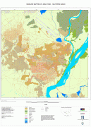
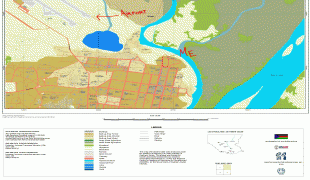
Map - Juba (Juba)
Map


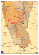
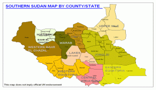
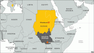

Country - South_Sudan
 |
 |
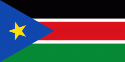
| Flag of South Sudan | |
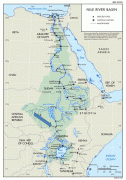
South Sudan gained independence from Sudan on 9 July 2011, making it the most recent sovereign state or country with widespread recognition as of 2023. It includes the vast swamp region of the Sudd, formed by the White Nile and known locally as the Bahr al Jabal, meaning "Mountain River". Sudan was occupied by Egypt under the Muhammad Ali dynasty and was governed as an Anglo-Egyptian condominium until Sudanese independence in 1956. Following the First Sudanese Civil War, the Southern Sudan Autonomous Region was formed in 1972 and lasted until 1983. A second Sudanese civil war soon broke out in 1983 and ended in 2005 with the Comprehensive Peace Agreement. Later that year, southern autonomy was restored when an Autonomous Government of Southern Sudan was formed. South Sudan became an independent state on 9 July 2011, following 98.83% support for independence in a January 2011 referendum. It has suffered ethnic violence and endured a civil war characterized by rampant human rights abuses, including various ethnic massacres and killings of journalists by various parties to the conflict from December 2013 until February 2020, when competing combat leaders Salva Kiir Mayardit and Riek Machar struck a unity deal and formed a coalition government, paving the way for refugees to return home.
Currency / Language
| ISO | Currency | Symbol | Significant figures |
|---|---|---|---|
| SSP | South Sudanese pound | £ | 2 |
| ISO | Language |
|---|---|
| EN | English language |