L.F. Wade International Airport (L.F. Wade International Airport)
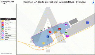
L.F. Wade International Airport, formerly named Bermuda International Airport, is the sole airport serving the British overseas territory of Bermuda in the North Atlantic Ocean. It is located in the parish of St. George's and is 6 NM northeast of Bermuda's capital, Hamilton. In 2016, L.F. Wade International Airport handled about 402,925 passengers, up 5.6% from 2006. It has one passenger terminal, one cargo terminal, eight aircraft stands and can support all aircraft sizes up to and including the Airbus A380. Currently, eight passenger or cargo airlines operate seasonal or year-round scheduled services to Bermuda Airport from Canada, the United Kingdom, and the United States.
The airfield was constructed during World War II for use as Kindley Field, a joint US Army Air Forces (USAAF)/Royal Air Force (RAF) base. The RAF forces in Bermuda were withdrawn at the end of the War. The local RAF Commander, however, stayed on, on loan to the Bermuda Government. He converted the RAF facilities into the Civil Air Terminal, operated by the local government. When the pre-war airport, a flying boat facility on Darrell's Island, closed in 1948, Bermuda's air routes were taken over by land planes operating through the airfield.
By then it was operated by the United States Air Force, as Kindley Air Force Base. In 1970, the field was transferred to the United States Navy, which operated it as US Naval Air Station, Bermuda until 1995. The US Navy terminated its 99-year lease and transferred the field to the Bermuda Government. It now operates the airport as part of the Ministry of Tourism & Transport.
The US Navy was not required to meet international civil air standards, despite the operation of civil airlines to the base. The Bermuda Government, however, was required to meet these standards very quickly on assuming control, and at some expense. This involved changes to the airfield lighting, erecting new fences, levelling anything over a certain height and within a certain distance of the runway (including the former base commander's residence, and the hill it stood on), and other changes.
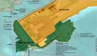
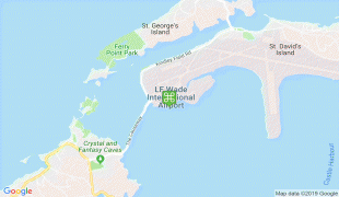
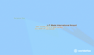
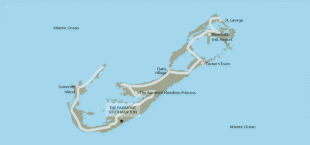
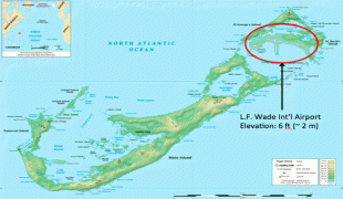
The airport is at the west of St. David's Island, and to the south of Ferry Reach. This places it in the East End of the archipelago, several miles from the capital, Hamilton.
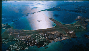
The airfield was built between 1941 and 1943 by levelling Long Bird Island and several smaller islands, and filling in the waterways with reclaimed land between them and St. David's Island. This created a landmass contiguous with St. David's. The airfield is typically described as being in, or on, St. David's. The field originally had three runways, but only the longest is still in use. One of the others, most of which is on a narrow peninsula jutting into Castle Harbour, has been blocked by munitions bunkers that were built at the harbour end.
Additional bunkers are on the west side of the peninsula, which the US Navy had referred to as the Weapons Pier. Airport workers, today, refer to it as The Finger. The other former runway is today a taxiway to connect aprons one and two to the active runway, and the taxiway which parallels it. This was last used as a runway in 1978. It has its own former taxiway paralleling it, which now serves as a dispersal area for visiting aircraft.
On 16 April 2007 the airport was renamed as "L.F. Wade International Airport" in honour of L. Frederick Wade, a former leader of the incumbent governing party (the Progressive Labour Party) when it was in opposition. The name was criticised by the opposition United Bermuda Party for being politically biased.
On 16 March 2017, the Government of Bermuda signed an agreement with the Canadian Commercial Corporation, granting Skyport a 30-year concession to manage and operate the airport.
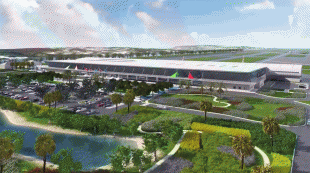
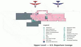
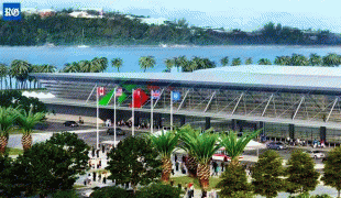
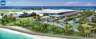
In December 2020, a new terminal was completed, replacing the previous one.
The airfield was constructed during World War II for use as Kindley Field, a joint US Army Air Forces (USAAF)/Royal Air Force (RAF) base. The RAF forces in Bermuda were withdrawn at the end of the War. The local RAF Commander, however, stayed on, on loan to the Bermuda Government. He converted the RAF facilities into the Civil Air Terminal, operated by the local government. When the pre-war airport, a flying boat facility on Darrell's Island, closed in 1948, Bermuda's air routes were taken over by land planes operating through the airfield.
By then it was operated by the United States Air Force, as Kindley Air Force Base. In 1970, the field was transferred to the United States Navy, which operated it as US Naval Air Station, Bermuda until 1995. The US Navy terminated its 99-year lease and transferred the field to the Bermuda Government. It now operates the airport as part of the Ministry of Tourism & Transport.
The US Navy was not required to meet international civil air standards, despite the operation of civil airlines to the base. The Bermuda Government, however, was required to meet these standards very quickly on assuming control, and at some expense. This involved changes to the airfield lighting, erecting new fences, levelling anything over a certain height and within a certain distance of the runway (including the former base commander's residence, and the hill it stood on), and other changes.
The airport is at the west of St. David's Island, and to the south of Ferry Reach. This places it in the East End of the archipelago, several miles from the capital, Hamilton.
The airfield was built between 1941 and 1943 by levelling Long Bird Island and several smaller islands, and filling in the waterways with reclaimed land between them and St. David's Island. This created a landmass contiguous with St. David's. The airfield is typically described as being in, or on, St. David's. The field originally had three runways, but only the longest is still in use. One of the others, most of which is on a narrow peninsula jutting into Castle Harbour, has been blocked by munitions bunkers that were built at the harbour end.
Additional bunkers are on the west side of the peninsula, which the US Navy had referred to as the Weapons Pier. Airport workers, today, refer to it as The Finger. The other former runway is today a taxiway to connect aprons one and two to the active runway, and the taxiway which parallels it. This was last used as a runway in 1978. It has its own former taxiway paralleling it, which now serves as a dispersal area for visiting aircraft.
On 16 April 2007 the airport was renamed as "L.F. Wade International Airport" in honour of L. Frederick Wade, a former leader of the incumbent governing party (the Progressive Labour Party) when it was in opposition. The name was criticised by the opposition United Bermuda Party for being politically biased.
On 16 March 2017, the Government of Bermuda signed an agreement with the Canadian Commercial Corporation, granting Skyport a 30-year concession to manage and operate the airport.
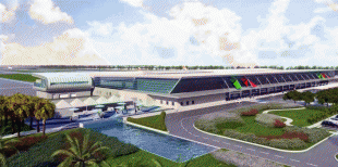
In December 2020, a new terminal was completed, replacing the previous one.
| IATA Code | BDA | ICAO Code | TXKF | FAA Code | |
|---|---|---|---|---|---|
| Telephone | (441) 293-2470 | Fax | (441) 293 4504 | ||
| Home page | Hyperlink |
Map - L.F. Wade International Airport (L.F. Wade International Airport)
Map


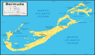
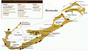
Country - Bermuda
 |
 |
Bermuda is named after Spanish explorer Juan de Bermúdez, who discovered the archipelago in 1505. The islands have been permanently inhabited since 1612, and, forming part of British America, became a crown colony in 1684. The first African slaves arrived in 1616, but as the slave trade ceased by the end of the 17th century, the colony developed into a base for merchants, privateers, and the Royal Navy. More recently, tourism has been a significant contributor to Bermuda's economy. After World War II the territory became an offshore financial centre and tax haven.
Currency / Language
| ISO | Currency | Symbol | Significant figures |
|---|---|---|---|
| BMD | Bermudian dollar | $ | 2 |
| USD | United States dollar | $ | 2 |
| ISO | Language |
|---|---|
| EN | English language |
| PT | Portuguese language |