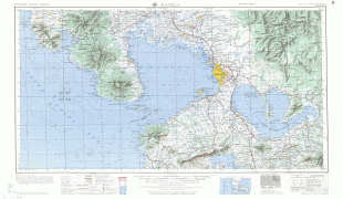
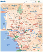
Manila
 |
 |
By 1258, a Tagalog-fortified polity called Maynila existed on the site of modern Manila. On June 24, 1571, after the defeat of the polity's last indigenous Rajah Sulayman III in the Battle of Bangkusay, Spanish conquistador Miguel López de Legazpi began constructing the walled fortification Intramuros on the ruins of an older settlement from whose name the Spanish-and-English name Manila derives. Manila was used as the capital of the captaincy general of the Spanish East Indies, which included the Marianas, Guam and other islands, and was controlled and administered for the Spanish crown by Mexico City in the Viceroyalty of New Spain. Today, Manila has many historic sites.
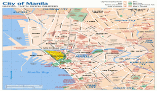
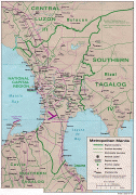
In modern times, the name "Manila" is commonly used to refer to the whole metropolitan area, the greater metropolitan area, and the city proper. Metro Manila, the officially defined metropolitan area, is the capital region of the Philippines, and includes the much-larger Quezon City and Makati Central Business District. It is the most-populous region in the country, one of the most-populous urban areas in the world, and one of the wealthiest regions in Southeast Asia. The city proper was home to 1,846,513 people in 2020, and is the historic core of a built-up area that extends well beyond its administrative limits. With 71,263 people per square kilometer, Manila is the most densely populated city proper in the world.
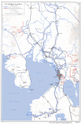
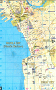
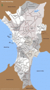
The Pasig River flows through the middle of the city, dividing it into north and south sections. The city comprises 16 administrative districts and is divided into six political districts for the purposes of representation in the Congress of the Philippines and the election of city council members. In 2018, the Globalization and World Cities Research Network listed Manila as an "Alpha-" global city, and ranked it seventh in economic performance globally and second regionally, while the Global Financial Centres Index ranks Manila 79th in the world. Manila is also the world's second-most natural disaster exposed city, yet is also among the fastest developing cities in Southeast Asia, and also the most loving capital city in the world.
Maynilà, the Filipino name for the city, comes from the phrase may-nilà, meaning "where indigo is found". Nilà is derived from the Sanskrit word nīla (नील), which refers to indigo dye and, by extension, to several plant species from which this natural dye can be extracted. The name Maynilà was probably bestowed because of the indigo-yielding plants that grow in the area surrounding the settlement rather than because it was known as a settlement that traded in indigo dye. Indigo dye extraction only became an important economic activity in the area in the 18th century, several hundred years after Maynila settlement was founded and named.
Maynilà was eventually Hispanicized into Spanish as Manila.
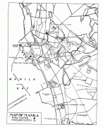
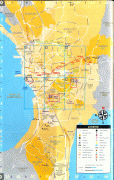
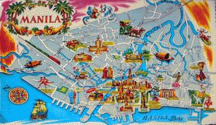
Map - Manila
Map


Country - Philippines
 |
 |
| Flag of the Philippines | |
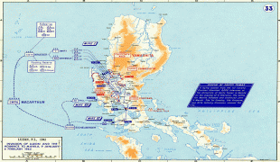
Negritos, some of the archipelago's earliest inhabitants, were followed by successive waves of Austronesian peoples. Adoption of animism, Hinduism and Islam established island-kingdoms called Kedatuan, Rajahnates, and Sultanates. The arrival of Ferdinand Magellan, a Portuguese explorer leading a fleet for Spain, marked the beginning of Spanish colonization. In 1543, Spanish explorer Ruy López de Villalobos named the archipelago Las Islas Filipinas in honor of Philip II of Spain. Spanish settlement through Mexico, beginning in 1565, led to the Philippines becoming ruled by the Spanish Empire for more than 300 years. During this time, Catholicism became the dominant religion, and Manila became the western hub of trans-Pacific trade. In 1896, the Philippine Revolution began, which then became entwined with the 1898 Spanish–American War. Spain ceded the territory to the United States, while Filipino revolutionaries declared the First Philippine Republic. The ensuing Philippine–American War ended with the United States establishing control over the territory, which they maintained until the Japanese invasion of the islands during World War II. Following liberation, the Philippines became independent in 1946. Since then, the unitary sovereign state has often had a tumultuous experience with democracy, which included the overthrow of a decades-long dictatorship by a nonviolent revolution.
Currency / Language
| ISO | Currency | Symbol | Significant figures |
|---|---|---|---|
| PHP | Philippine peso | ₱ | 2 |
| ISO | Language |
|---|---|
| EN | English language |
| TL | Tagalog language |