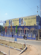
Mbuji-Mayi
Mbuji-Mayi lies in Luba country on the Mbuji-Mayi River. The name Mbuji-Mayi comes from the local language, Tshiluba, and translates as "Goat-Water," a name deriving from the great number of goats in the region. Despite its large population, the city remains remote, having little connection to surrounding provinces or to Kinshasa and Lubumbashi. However, Mbuji-Mayi is the traditional centre of industrial diamond mining in Congo, with it being located on top of one of the largest known deposits in the world. Air travel is provided through the Mbuji Mayi Airport.
Mbuji-Mayi is made up of five communes (municipalities), each headed by a burgomaster: Bipemba, Dibindi, Diulu, Kanshi and Muya. This division into communes has been in effect since Ministerial (Departmental) Order No. 83 of March 4, 1968 of the Minister of the Interior.
Map - Mbuji-Mayi
Map


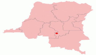


Country - Democratic_Republic_of_the_Congo
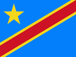 |
 |
| Flag of the Democratic Republic of the Congo | |
Centered on the Congo Basin, the territory of the DRC was first inhabited by Central African foragers around 90,000 years ago and was reached by the Bantu expansion about 3,000 years ago. In the west, the Kingdom of Kongo ruled around the mouth of the Congo River from the 14th to 19th centuries. In the northeast, center and east, the kingdoms of Azande, Luba, and Lunda ruled from the 16th and 17th centuries to the 19th century. King Leopold II of Belgium formally acquired rights to the Congo territory in 1885 and declared the land his private property, naming it the Congo Free State. From 1885 to 1908, his colonial military forced the local population to produce rubber and committed widespread atrocities. In 1908, Leopold ceded the territory, which thus became a Belgian colony.
Currency / Language
| ISO | Currency | Symbol | Significant figures |
|---|---|---|---|
| CDF | Congolese franc | Fr | 2 |
| ISO | Language |
|---|---|
| FR | French language |
| KG | Kongo language |
| LN | Lingala language |