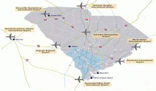
Myrtle Beach International Airport (Myrtle Beach International Airport)
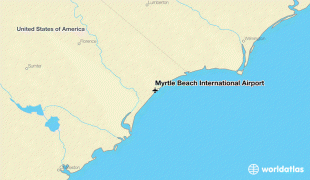
Myrtle Beach International Airport is a county-owned public-use airport located three nautical miles (6 km) southwest of the central business district of Myrtle Beach, in Horry County, South Carolina, United States. It was formerly known as Myrtle Beach Jetport (1974–1989) and is located on site of the former Myrtle Beach Air Force Base, which also includes The Market Common shopping complex.
The Federal Aviation Administration (FAA) National Plan of Integrated Airport Systems for 2017–2021 categorized it as a small-hub primary commercial service facility. Myrtle Beach has the second-busiest airport in South Carolina behind Charleston, with over 2.4 million passengers (arriving and departing) in 2018.
The airport's official website since 2006 is flymyrtlebeach.com, which was previously an unofficial website owned by an airport employee. In July 2012 the airport launched a redesigned website with a new logo.
An airport was started on property from a former army base which the federal government transferred in 1948 through the Surplus Property Act. The city of Myrtle Beach decided not to use the property for an airport but funds from the property still had to be used for an airport. From 1958 to 1976 these funds went to Horry County Jetport in Crescent Beach, which moved to the northeast part of the base after an agreement for joint civilian and military use of the base. In 1977, the City of Myrtle Beach annexed the area of Myrtle Beach Airport. Until 1993, both MYR and Myrtle Beach AFB jointly used the main runway; this limited civil operations to 30 landings per day and led to a local business movement to build an entirely new airport.
In the 1980s, the airport was served by Piedmont Airlines mainline aircraft (later acquired by USAir) and by Delta and Eastern commuter aircraft.
In 1993, the Air Force closed the base as a result of BRAC 1991. The runway and other portions of the former military flight line were then turned over to the Horry County Department of Airports.
American Eagle became a major carrier at MYR in the early 1990s, operating multiple daily ATR 72 flights to the American Airlines hub at Raleigh–Durham International Airport. By late 1994 this route accounted for as much as 12% of the airport's passenger traffic; however, American abruptly ended its American Eagle hub at Raleigh–Durham in December 1994, cancelling all service to MYR and other secondary airports in the region. American returned to Myrtle Beach in 2010 with a seasonal service to Dallas/Fort Worth International Airport.
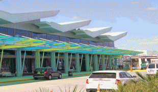
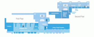
On April 1, 1996, Myrtle Beach Airport became an international airport. A new international terminal had its grand opening August 21 of that year, and a new logo was unveiled "to reflect the architectural design of the airport's terminal and the influence of the beach by showing a pained window and a palm tree in blues and greens".
The airport served as the main hub for Hooters Air from 2003 until 2006. The airport authority offered discounted hangar space and other undisclosed benefits to Hooters Air operator Pace Airlines in an effort to relocate its operating base from Smith Reynolds Airport in Winston-Salem, North Carolina. However, Pace decided to keep its base (also used for charter operations) in Winston-Salem.
In 2006 AirTran Airways discontinued its service to Atlanta; it was the fourth-largest airline serving Myrtle Beach International at the time.
The Federal Aviation Administration (FAA) National Plan of Integrated Airport Systems for 2017–2021 categorized it as a small-hub primary commercial service facility. Myrtle Beach has the second-busiest airport in South Carolina behind Charleston, with over 2.4 million passengers (arriving and departing) in 2018.
The airport's official website since 2006 is flymyrtlebeach.com, which was previously an unofficial website owned by an airport employee. In July 2012 the airport launched a redesigned website with a new logo.
An airport was started on property from a former army base which the federal government transferred in 1948 through the Surplus Property Act. The city of Myrtle Beach decided not to use the property for an airport but funds from the property still had to be used for an airport. From 1958 to 1976 these funds went to Horry County Jetport in Crescent Beach, which moved to the northeast part of the base after an agreement for joint civilian and military use of the base. In 1977, the City of Myrtle Beach annexed the area of Myrtle Beach Airport. Until 1993, both MYR and Myrtle Beach AFB jointly used the main runway; this limited civil operations to 30 landings per day and led to a local business movement to build an entirely new airport.
In the 1980s, the airport was served by Piedmont Airlines mainline aircraft (later acquired by USAir) and by Delta and Eastern commuter aircraft.
In 1993, the Air Force closed the base as a result of BRAC 1991. The runway and other portions of the former military flight line were then turned over to the Horry County Department of Airports.
American Eagle became a major carrier at MYR in the early 1990s, operating multiple daily ATR 72 flights to the American Airlines hub at Raleigh–Durham International Airport. By late 1994 this route accounted for as much as 12% of the airport's passenger traffic; however, American abruptly ended its American Eagle hub at Raleigh–Durham in December 1994, cancelling all service to MYR and other secondary airports in the region. American returned to Myrtle Beach in 2010 with a seasonal service to Dallas/Fort Worth International Airport.
On April 1, 1996, Myrtle Beach Airport became an international airport. A new international terminal had its grand opening August 21 of that year, and a new logo was unveiled "to reflect the architectural design of the airport's terminal and the influence of the beach by showing a pained window and a palm tree in blues and greens".
The airport served as the main hub for Hooters Air from 2003 until 2006. The airport authority offered discounted hangar space and other undisclosed benefits to Hooters Air operator Pace Airlines in an effort to relocate its operating base from Smith Reynolds Airport in Winston-Salem, North Carolina. However, Pace decided to keep its base (also used for charter operations) in Winston-Salem.
In 2006 AirTran Airways discontinued its service to Atlanta; it was the fourth-largest airline serving Myrtle Beach International at the time.
| IATA Code | MYR | ICAO Code | KMYR | FAA Code | |
|---|---|---|---|---|---|
| Telephone | Fax | ||||
| Home page |
Map - Myrtle Beach International Airport (Myrtle Beach International Airport)
Map


Country - United_States
 |
 |
| Flag of the United States | |
Indigenous peoples have inhabited the Americas for thousands of years. Beginning in 1607, British colonization led to the establishment of the Thirteen Colonies in what is now the Eastern United States. They quarreled with the British Crown over taxation and political representation, leading to the American Revolution and proceeding Revolutionary War. The United States declared independence on July 4, 1776, becoming the first nation-state founded on Enlightenment principles of unalienable natural rights, consent of the governed, and liberal democracy. The country began expanding across North America, spanning the continent by 1848. Sectional division surrounding slavery in the Southern United States led to the secession of the Confederate States of America, which fought the remaining states of the Union during the American Civil War (1861–1865). With the Union's victory and preservation, slavery was abolished nationally by the Thirteenth Amendment.
Currency / Language
| ISO | Currency | Symbol | Significant figures |
|---|---|---|---|
| USD | United States dollar | $ | 2 |
| ISO | Language |
|---|---|
| EN | English language |
| FR | French language |
| ES | Spanish language |