Mäntsälä
 |
Mäntsälä lies about 60 km north of Helsinki, the capital of Finland. During the last few years, the population of Mäntsälä has been one of the most rapidly increasing in Finland. A new railway, the Kerava–Lahti railway line, was built between Kerava and Lahti with passenger traffic starting on 4 September 2006 from Mäntsälä railway station. Helsinki is about 40 minutes away, and Lahti even closer. Highway 4 (E75) connecting both cities passes through Mäntsälä.
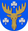
The coat of arms of Mäntsälä has its theme in the region's traditional livelihoods; the head of the moose refers to the hunting lands of the region, and the clovers symbolizes local agriculture. The coat of arms was designed by Olof Eriksson and approved by the Mäntsälä Municipal Council on 16 December 1950. The coat of arms was officially approved by the Ministry of the Interior on 20 February 1951.
Mäntsälä is considered to have been founded in 1585, when the community's first church was built. The current church was completed in 1866 after delay. The Crimean War affected also Mäntsälä: funds for building the church were spent on war efforts. All of the churches were located on Kirkonmäki ("Church Hill") at about the same spot.
The first common school was founded in 1870 by way of a testament of clergyman Abraham Ehnroos. To his credit is the founding of a public library already in 1840. An intermediate school was not founded until 1945 with a high school following in 1954, previously facilities in Porvoo, Järvenpää and Helsinki were used.
In 1854 the first town hall was built on Kirkonmäki. Today a museum is operating in the building, having also served as a morgue, school kitchen and lesson space, and a dormitory. It is deteriorating severely and the museum is only opened upon request.
The second town hall was built in 1935, also on Kirkonmäki. It served until the completion of the present town hall in 1992. Now it houses an open college.
There is a total of 15 manors in Mäntsälä, 4 of which are open to the public, the rest being private residences. Russian czar Alexander I visited as guest of Ulla Möllersvärd in 1809 in the Mäntsälä manor lying in the town center. The manors emerged in the 17th century as noblemen feoffs. Traditionally the land belonged to the manors. There were many crofts in Mäntsälä and new legislation in 1918 enabled the crofters to claim the land for themselves. In the 1920s the manors were still a sizable land owner in the parish.
Mäntsälä is especially known for the Mäntsälä rebellion. About 400 civil guards went shooting to a Social Democratic party rally at Ohkola community hall, interrupting it. In the course of a few days leaders of Lapua Movement and armed civil guards from all over the country arrived to Mäntsälä. The government ordered them arrested, and after a speech by president Svinhufvud on 2 March the situation gradually settled down. The movement disbanded early in spring.
World War II brought about 2000 refugees evacuated from Karelia to Mäntsälä. They came mainly from Kirvu and Koivisto. Land was cut from the manors again for the arrivals, reducing manor estate considerably. In 1985 a museum about the Kirvu parish was opened next to the church in the city center.
Map - Mäntsälä
Map
Country - Finland
 |
 |
| Flag of Finland | |
Finland was first inhabited around 9000 BC after the Last Glacial Period. The Stone Age introduced several different ceramic styles and cultures. The Bronze Age and Iron Age were characterized by contacts with other cultures in Fennoscandia and the Baltic region. From the late 13th century, Finland became a part of Sweden as a consequence of the Northern Crusades. In 1809, as a result of the Finnish War, Finland became part of the Russian Empire as the autonomous Grand Duchy of Finland, during which Finnish art flourished and the idea of independence began to take hold. In 1906, Finland became the first European state to grant universal suffrage, and the first in the world to give all adult citizens the right to run for public office. After the 1917 Russian Revolution, Finland declared independence from Russia. In 1918, the fledgling state was divided by the Finnish Civil War. During World War II, Finland fought the Soviet Union in the Winter War and the Continuation War, and Nazi Germany in the Lapland War. It subsequently lost parts of its territory, but maintained its independence.
Currency / Language
| ISO | Currency | Symbol | Significant figures |
|---|---|---|---|
| EUR | Euro | € | 2 |
| ISO | Language |
|---|---|
| FI | Finnish language |
| SV | Swedish language |


