Nassau (Nassau)
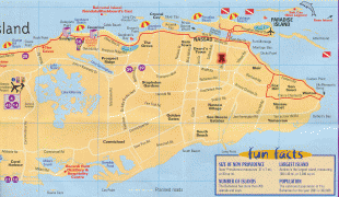
Nassau is the capital and largest city of the Bahamas. With a population of 274,400 as of 2016, or just over 70% of the entire population of the Bahamas, Nassau is commonly defined as a primate city, dwarfing all other towns in the country. It is the centre of commerce, education, law, administration, and media of the country.
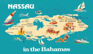
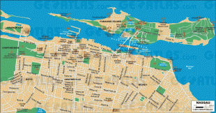
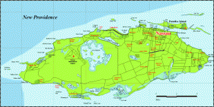
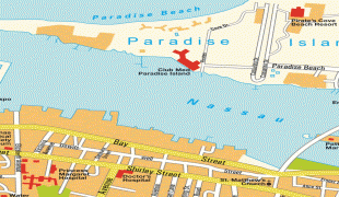
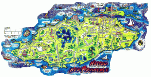
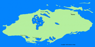
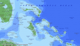
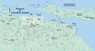
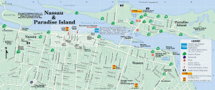
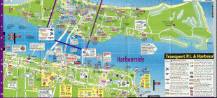
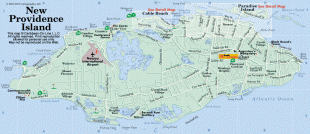
Lynden Pindling International Airport, the major airport for the Bahamas, is located about 16 km west of the city centre of Nassau, and has daily flights to major cities in Canada, the Caribbean, the United Kingdom and the United States. The city is located on the island of New Providence.
Nassau is the site of the House of Assembly and various judicial departments and was considered historically to be a stronghold of pirates. The city was named in honour of William III of England, Prince of Orange-Nassau.
Nassau's modern growth began in the late eighteenth century, with the influx of thousands of Loyalists and their slaves to the Bahamas following the American War of Independence. Many of them settled in Nassau and eventually came to outnumber the original inhabitants.
As the population of Nassau grew, so did its populated areas. Today the city dominates the entire island and its satellite, Paradise Island. However, until the post-Second World War era, the outer suburbs scarcely existed. Most of New Providence was uncultivated bush until Loyalists were resettled there following the American Revolutionary War; they established several plantations, such as Clifton and Tusculum. Slaves were imported as labour.
After the British abolished the international slave trade in 1807, they resettled thousands of Africans liberated from slave ships by the Royal Navy on New Providence (at Adelaide Village and Gambier Village), along with other islands such as Grand Bahama, Exuma, Abaco and Inagua. In addition, slaves freed from American ships, such as the Creole case in 1841, were allowed to settle there. The largest concentration of Africans historically lived in the "Over-the-Hill" suburbs of Grants Town and Bain Town to the south of the city of Nassau, while most of the inhabitants of European descent lived on the island's northern coastal ridges.
The town that would be called Nassau was founded in 1670 by British noblemen who brought British settlers with them to New Providence. They built a fort, and named it Charles Town in honour of England’s King Charles II. During this time there were frequent wars with the Spanish, and Charles Town was used as a base for privateering against them. In 1684 the town was burned to the ground during the Raid on Charles Town. It was rebuilt in 1695 under Governor Nicholas Trott and renamed Nassau in honour of William of Orange, who belonged to a branch of the House of Nassau. William was the Dutch Stadtholder (stadhouder in Dutch), and, from 1689, William III, the King of England, Scotland and Ireland. The name Nassau ultimately derives from the town of Nassau in Germany.
Lacking effective governors after Trott, Nassau fell on hard times. In 1703 Spanish and French allied forces briefly occupied Nassau. More so, Nassau suffered greatly during the War of Spanish Succession and had witnessed Spanish incursions during 1703, 1704 and 1706. From 1703 to 1718 there was no legitimate governor in the colony. Thomas Walker was the island's last remaining appointed official and although evidence is scarce, it appears that he was acting in the role of deputy governor upon Benjamin Hornigold's arrival in 1713. By this time, the sparsely settled Bahamas had become a pirate haven known as New Providence. The Governor of Bermuda stated that there were over 1,000 pirates in Nassau and that they outnumbered the mere hundred inhabitants of the town. They proclaimed Nassau a pirate republic, recognising the island's prosperous state in which it offered fresh fruit, meat and water and plenty of protection amid its waterways. Nassau's harbour was tailor-made for defence and it could take around 500 vessels, though it was too shallow to accept large battleships. Benjamin Hornigold, along with his great rival Henry Jennings, became the unofficial overlord of a veritable pirate republic which played host to the self-styled Flying Gang. Other pirates that used Nassau as their base included Charles Vane, Thomas Barrow (who declared himself "Governor of New Providence"), Calico Jack Rackham, Anne Bonny, Mary Read, and the infamous Edward Teach, better known as "Blackbeard".
In 1718, the British sought to regain control of the islands and appointed Captain Woodes Rogers as Royal governor. He successfully clamped down on the pirates, reformed the civil administration, and restored commerce. Rogers cleaned up Nassau and rebuilt the fort, using his own wealth to try to overcome problems. In 1720, the Spanish attacked Nassau but failed to capture the town and the island.
During the wars in the Thirteen Colonies, Nassau experienced an economic boom. With funds from privateering, a new fort, street lights and over 2300 sumptuous houses were built and Nassau was extended. In addition to this, mosquito breeding swamps were filled.
Map - Nassau (Nassau)
Map


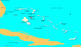
Country - The_Bahamas
 |
 |
The Bahama Islands were inhabited by the Lucayans, a branch of the Arawakan-speaking Taíno, for many centuries. Christopher Columbus was the first European to see the islands, making his first landfall in the "New World" in 1492 when he landed on the island of San Salvador. Later, the Spanish shipped the native Lucayans to and enslaved them on Hispaniola, after which the Bahama islands were mostly deserted from 1513 until 1648, nearly all native Bahamians having been forcibly removed for enslavement or having died of diseases that Europeans brought to the islands. In 1649, English colonists from Bermuda, known as the Eleutheran Adventurers, settled on the island of Eleuthera.
Currency / Language
| ISO | Currency | Symbol | Significant figures |
|---|---|---|---|
| BSD | Bahamian dollar | $ | 2 |
| ISO | Language |
|---|---|
| EN | English language |