Norway (Kingdom of Norway)
 |
 |
| Flag of Norway | |
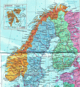
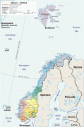
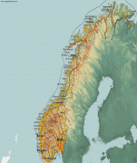
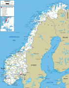
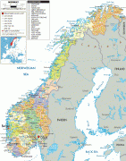
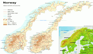
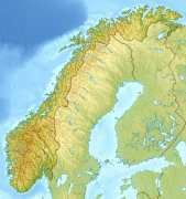
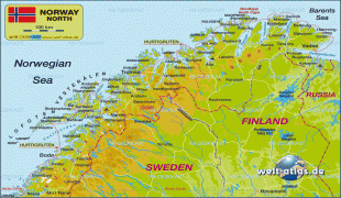
Norway has a total area of 385,207 km2 and had a population of 5,425,270 in January 2022. The country shares a long eastern border with Sweden at a length of 1,619 km. It is bordered by Finland and Russia to the northeast and the Skagerrak strait to the south, on the other side of which are Denmark and the United Kingdom. Norway has an extensive coastline, facing the North Atlantic Ocean and the Barents Sea. The maritime influence dominates Norway's climate, with mild lowland temperatures on the sea coasts; the interior, while colder, is also significantly milder than areas elsewhere in the world on such northerly latitudes. Even during polar night in the north, temperatures above freezing are commonplace on the coastline. The maritime influence brings high rainfall and snowfall to some areas of the country.
Harald V of the House of Glücksburg is the current King of Norway. Jonas Gahr Støre has been prime minister since 2021, replacing Erna Solberg. As a unitary sovereign state with a constitutional monarchy, Norway divides state power between the parliament, the cabinet and the supreme court, as determined by the 1814 constitution. The kingdom was established in 872 as a merger of many petty kingdoms and has existed continuously for 1,0 years. From 1537 to 1814, Norway was a part of the Kingdom of Denmark–Norway, and, from 1814 to 1905, it was in a personal union with the Kingdom of Sweden. Norway was neutral during the First World War, and also in World War II until April 1940 when the country was invaded and occupied by Nazi Germany until the end of the war.
Norway has both administrative and political subdivisions on two levels: counties and municipalities. The Sámi people have a certain amount of self-determination and influence over traditional territories through the Sámi Parliament and the Finnmark Act. Norway maintains close ties with both the European Union and the United States. Norway is also a founding member of the United Nations, NATO, the European Free Trade Association, the Council of Europe, the Antarctic Treaty, and the Nordic Council; a member of the European Economic Area, the WTO, and the OECD; and a part of the Schengen Area. In addition, the Norwegian languages share mutual intelligibility with Danish and Swedish.
Norway maintains the Nordic welfare model with universal health care and a comprehensive social security system, and its values are rooted in egalitarian ideals. The Norwegian state has large ownership positions in key industrial sectors, having extensive reserves of petroleum, natural gas, minerals, lumber, seafood, and fresh water. The petroleum industry accounts for around a quarter of the country's gross domestic product (GDP). On a per-capita basis, Norway is the world's largest producer of oil and natural gas outside of the Middle East.
The country has the fourth-highest per-capita income in the world on the World Bank and IMF lists. On the CIA's GDP (PPP) per capita list (2015 estimate) which includes autonomous territories and regions, Norway ranks as number eleven. It has the world's largest sovereign wealth fund, with a value of US$1 trillion. Norway has the second highest Human Development Index ranking in the world, previously holding the top position between 2001 and 2006, and between 2009 and 2019; it also has the second highest inequality-adjusted ranking per 2021. Norway ranked first on the World Happiness Report for 2017 and currently ranks first on the OECD Better Life Index, the Index of Public Integrity, the Freedom Index, and the Democracy Index. Norway also has one of the lowest crime rates in the world.
Although the majority of Norway's population is ethnic Norwegian, in the 21st century immigration has accounted for more than half of population growth; in 2021, the five largest minority groups in the country were the descendants of Polish, Lithuanian, Somali, Pakistani, and Swedish immigrants.
Norway has two official names: Norge in Bokmål and Noreg in Nynorsk. The English name Norway comes from the Old English word Norþweg mentioned in 880, meaning "northern way" or "way leading to the north", which is how the Anglo-Saxons referred to the coastline of Atlantic Norway similar to leading theory about the origin of the Norwegian language name. The Anglo-Saxons of Britain also referred to the kingdom of Norway in 880 as Norðmanna land.
There is some disagreement about whether the native name of Norway originally had the same etymology as the English form. According to the traditional dominant view, the first component was originally norðr, a cognate of English north, so the full name was Norðr vegr, "the way northwards", referring to the sailing route along the Norwegian coast, and contrasting with suðrvegar "southern way" (from Old Norse suðr) for (Germany), and austrvegr "eastern way" (from austr) for the Baltic. In the translation of Orosius for Alfred, the name is Norðweg, while in younger Old English sources the ð is gone. In the tenth century many Norsemen settled in Northern France, according to the sagas, in the area that was later called Normandy from norðmann (Norseman or Scandinavian ), although not a Norwegian possession. In France normanni or northmanni referred to people of Norway, Sweden or Denmark. Until around 1800, inhabitants of Western Norway were referred to as nordmenn (northmen) while inhabitants of Eastern Norway were referred to as austmenn (eastmen).
According to another theory, the first component was a word nór, meaning "narrow" (Old English nearu), referring to the inner-archipelago sailing route through the land ("narrow way"). The interpretation as "northern", as reflected in the English and Latin forms of the name, would then have been due to later folk etymology. This latter view originated with philologist Niels Halvorsen Trønnes in 1847; since 2016 it is also advocated by language student and activist Klaus Johan Myrvoll and was adopted by philology professor Michael Schulte. The form Nore is still used in placenames such as the village of Nore and lake Norefjorden in Buskerud county, and still has the same meaning. Among other arguments in favour of the theory, it is pointed out that the word has a long vowel in Skaldic poetry and is not attested with < ð> in any native Norse texts or inscriptions (the earliest runic attestations have the spellings nuruiak and nuriki). This resurrected theory has received some pushback by other scholars on various grounds, e. g. the uncontroversial presence of the element norðr in the ethnonym norðrmaðr "Norseman, Norwegian person" (modern Norwegian nordmann), and the adjective norrǿnn "northern, Norse, Norwegian", as well as the very early attestations of the Latin and Anglo-Saxon forms with < th>.
Currency / Language
| ISO | Currency | Symbol | Significant figures |
|---|---|---|---|
| NOK | Norwegian krone | kr | 2 |
| ISO | Language |
|---|---|
| FI | Finnish language |
| SE | Northern Sami |
| NO | Norwegian language |
| NN | Nynorsk |