Map - Plzeň Region (Plzeňský kraj)

Plzeň Region (Plzeňský kraj)
Plzeň Region (Plzeňský kraj; Pilsner Region) is an administrative unit (kraj) in the western part of Bohemia in the Czech Republic. It is named after its capital Plzeň (English, Pilsen). In terms of area, Plzeň Region is 7,561 km2, the third largest region in the Czech Republic. However, with a population of about 585,000 inhabitants it is only the ninth most populous region. After the South Bohemian Region it is the second least densely populated region. The region can be roughly divided into two parts: a highly industrialized north-eastern part with a strong engineering tradition around Pilsen (Plzeň) and a more hilly and rural south-western part with smaller-sized manufacturing companies processing natural resources.

The region borders the Karlovy Vary Region (to the north-west), Ústí nad Labem Region (to the north), Central Bohemian Region (north-east), South Bohemian Region (to the east) and with Bavaria (part of Germany) in the south-west and west. The region was established based on the constitutional lax No. 347/97 of Collections concerning the formation of higher territorial administrative units. The region and its authorities are specified by Act No. 129/2000 of Collections concerning regions, which came into effect on the day of the regional authorities elections, or on 1 January 2001.

The Plzeň Region is divided into 7 districts (okresy):

The districts still exist as regional units though most administration has been shifted to the Municipalities with Extended Competence and the Municipalities with Commissioned Local Authority.

 
Map - Plzeň Region (Plzeňský kraj)
Map
Google Earth - Map - Plzeň Region
Google Earth
Openstreetmap - Map - Plzeň Region
Openstreetmap
Map - Plzeň Region - Esri.WorldImagery
Esri.WorldImagery
Map - Plzeň Region - Esri.WorldStreetMap
Esri.WorldStreetMap
Map - Plzeň Region - OpenStreetMap.Mapnik
OpenStreetMap.Mapnik
Map - Plzeň Region - OpenStreetMap.HOT
OpenStreetMap.HOT
Map - Plzeň Region - OpenTopoMap
OpenTopoMap
Map - Plzeň Region - CartoDB.Positron
CartoDB.Positron
Map - Plzeň Region - CartoDB.Voyager
CartoDB.Voyager
Map - Plzeň Region - OpenMapSurfer.Roads
OpenMapSurfer.Roads
Map - Plzeň Region - Esri.WorldTopoMap
Esri.WorldTopoMap
Map - Plzeň Region - Stamen.TonerLite
Stamen.TonerLite
Country - Czech_Republic
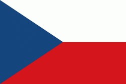
Flag of the Czech Republic
The Czech Republic, also known as Czechia, is a landlocked country in Central Europe. Historically known as Bohemia, it is bordered by Austria to the south, Germany to the west, Poland to the northeast, and Slovakia to the southeast. The Czech Republic has a hilly landscape that covers an area of 78871 km2 with a mostly temperate continental and oceanic climate. The capital and largest city is Prague; other major cities and urban areas include Brno, Ostrava, Plzeň and Liberec.

The Duchy of Bohemia was founded in the late 9th century under Great Moravia. It was formally recognized as an Imperial State of the Holy Roman Empire in 1002 and became a kingdom in 1198. Following the Battle of Mohács in 1526, the whole Crown of Bohemia was gradually integrated into the Habsburg monarchy. The Protestant Bohemian Revolt led to the Thirty Years' War. After the Battle of White Mountain, the Habsburgs consolidated their rule. With the dissolution of the Holy Empire in 1806, the Crown lands became part of the Austrian Empire.
Currency / Language  
ISO Currency Symbol Significant figures
CZK Czech koruna Kč 2
Neighbourhood - Country  
  •  Austria 
  •  Germany 
  •  Poland 
  •  Slovakia