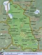
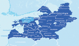
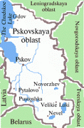
Pskov Oblast (Pskov Oblast)
 |
 |
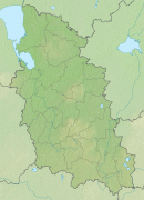
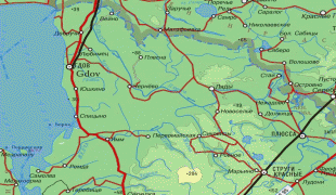
Pskov Oblast is the westernmost federal subject of contiguous Russia (Kaliningrad Oblast, while located further to the west, is an exclave). It borders with Leningrad Oblast in the north, Novgorod Oblast in the east, Tver and Smolensk Oblasts in the southeast, Vitebsk Oblast of Belarus in the south, and with the counties of Latvia (Alūksne Municipality, Balvi Municipality, and Ludza Municipality) and Estonia (Võru County) in the west. In the northwest, Pskov Oblast is limited by Lake Peipus, which makes up most of the state border with Estonia.
The oblast is located in the Baltic Sea drainage basin, mostly in the basin of the Narva River. The biggest river of this basin is the Velikaya, which flows across the whole oblast from south to north and drains into Lake Peipus. The drainage basin of the Velikaya covers the whole territory of the oblast, with the exception of relatively minor areas in its southern, eastern, and northeastern parts. The rivers in the southeast drain into the Lovat, which has its source in Belarus and crosses Pskov Oblast from south to north, continuing to Novgorod Oblast.
The Lovat is a major tributary of Lake Ilmen and is itself in the Neva River's basin. Another tributary of Lake Ilmen is the Shelon River, which flows in the eastern part of the oblast. Finally, minor areas in the south lie in the basin of the Western Dvina. A short stretch of the Western Dvina makes up the border between Pskov and Tver Oblasts.
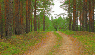
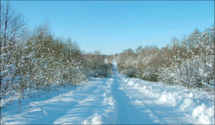
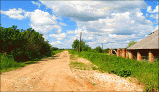
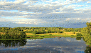
The north of the oblast is flat and swampy, whereas the central and the southern parts are formed by glacial landscapes. There are many lakes, especially in the south. The biggest one, after Lake Peipus, is Lake Zhizhitskoye, with an area of 51.3 km2. It is located in the southeast of the oblast, in the basin of the Western Dvina.
Wood is one of the most important natural resources in the oblast, with forests taking up to one-third of the territory. Total wood reserves as of January 1, 2005 were estimated to be at 331,200,000 m3.
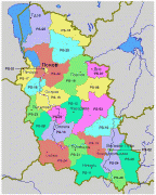
Map - Pskov Oblast (Pskov Oblast)
Map


Country - Russia
 |
 |
| Flag of Russia | |
The East Slavs emerged as a recognisable group in Europe between the 3rd and 8th centuries CE. The first East Slavic state, Kievan Rus', arose in the 9th century, and in 988, it adopted Orthodox Christianity from the Byzantine Empire. Rus' ultimately disintegrated, with the Grand Duchy of Moscow growing to become the Tsardom of Russia. By the early 18th century, Russia had vastly expanded through conquest, annexation, and the efforts of Russian explorers, developing into the Russian Empire, which remains the third-largest empire in history. However, with the Russian Revolution in 1917, Russia's monarchic rule was abolished and replaced by the Russian SFSR—the world's first constitutionally socialist state. Following the Russian Civil War, the Russian SFSR established the Soviet Union (with three other Soviet republics), within which it was the largest and principal constituent. At the expense of millions of lives, the Soviet Union underwent rapid industrialization in the 1930s, and later played a decisive role for the Allies of World War II by leading large-scale efforts on the Eastern Front. With the onset of the Cold War, it competed with the United States for global ideological influence; the Soviet era of the 20th century saw some of the most significant Russian technological achievements, including the first human-made satellite and the first human expedition into outer space.
Currency / Language
| ISO | Currency | Symbol | Significant figures |
|---|---|---|---|
| RUB | Russian ruble | ₽ | 2 |
| ISO | Language |
|---|---|
| CE | Chechen language |
| CV | Chuvash language |
| KV | Komi language |
| RU | Russian language |
| TT | Tatar language |


