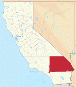
San Bernardino International Airport (San Bernardino International Airport)
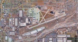
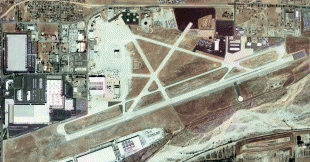
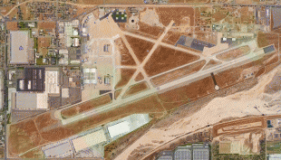
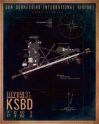
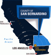
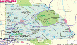
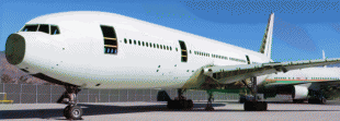
San Bernardino International Airport (, initialism: SBIA) is a public airport two miles (3 km) southeast of downtown San Bernardino, California, in San Bernardino County, California, United States. The airport covers 1329 acre and has one runway that can accommodate the largest existing aircraft, including the Airbus A380 and the Boeing 747.
The facility is a commercial, general aviation, and cargo airport on the site of the former San Bernardino Municipal Airport, which was converted during World War II into the San Bernardino Air Depot in 1942 and which was subsequently renamed, "Norton Air Force Base," before being decommissioned with the fall of the Soviet Union.
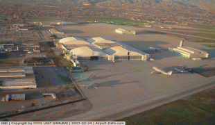
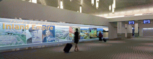
San Bernardino International Airport encompasses three passenger terminals, including the following: a domestic terminal where Breeze Airways operates daily non-stop service to and from San Francisco International and daily one-stop, direct flights to and from Provo, Utah; an international terminal with U.S. Customs and Border Protection; and, the Luxivair executive terminal, which is an airport-owned fixed-base operator.
The Norton Air Force Base opened shortly after the attacks on Pearl Harbor. Norton was placed on the Department of Defense's base closure list in 1989.
Most parts of San Bernardino International Airport were completed in 2011, though a customs facility was still under construction. San Bernardino International Airport was built to conform to aviation-demand modeling and allocations performed as part of the 2008 Regional Transportation Plan (R.T.P.) of the Southern California Association of Governments (SCAG), the Metropolitan Planning Organization for San Bernardino, Los Angeles, Riverside, Ventura, Imperial, and Orange counties.
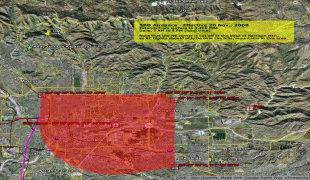
The 2008 R.T.P. projected 9.4 million passengers and 1.29 million tons of air cargo at San Bernardino International Airport in 2035 with improved ground access provided, in part, by high-speed rail. The California High-Speed Rail Authority is currently performing alternatives analysis regarding the Los Angeles-to-San Diego segment, which includes, along the I-215 alignment, an optional station location at Rialto Avenue and E Street in the city of San Bernardino. The 2008 R.T.P states, "The high speed, reliability, and predictability of high-speed airport access will be needed to overcome mounting and increasingly unpredictable traffic congestion (on area freeways)."
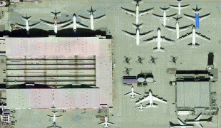
U.S. Customs and Border Protection agents are available on call to clear imported goods. The airport is used as a base for United States Forest Service planes fighting forest fires. Several hangars that were formerly empty have recently been occupied by civilian-owned aircraft maintenance companies. The runway is 10000 ft long, easily accommodating air cargo aircraft.
The facility is a commercial, general aviation, and cargo airport on the site of the former San Bernardino Municipal Airport, which was converted during World War II into the San Bernardino Air Depot in 1942 and which was subsequently renamed, "Norton Air Force Base," before being decommissioned with the fall of the Soviet Union.
San Bernardino International Airport encompasses three passenger terminals, including the following: a domestic terminal where Breeze Airways operates daily non-stop service to and from San Francisco International and daily one-stop, direct flights to and from Provo, Utah; an international terminal with U.S. Customs and Border Protection; and, the Luxivair executive terminal, which is an airport-owned fixed-base operator.
The Norton Air Force Base opened shortly after the attacks on Pearl Harbor. Norton was placed on the Department of Defense's base closure list in 1989.
Most parts of San Bernardino International Airport were completed in 2011, though a customs facility was still under construction. San Bernardino International Airport was built to conform to aviation-demand modeling and allocations performed as part of the 2008 Regional Transportation Plan (R.T.P.) of the Southern California Association of Governments (SCAG), the Metropolitan Planning Organization for San Bernardino, Los Angeles, Riverside, Ventura, Imperial, and Orange counties.
The 2008 R.T.P. projected 9.4 million passengers and 1.29 million tons of air cargo at San Bernardino International Airport in 2035 with improved ground access provided, in part, by high-speed rail. The California High-Speed Rail Authority is currently performing alternatives analysis regarding the Los Angeles-to-San Diego segment, which includes, along the I-215 alignment, an optional station location at Rialto Avenue and E Street in the city of San Bernardino. The 2008 R.T.P states, "The high speed, reliability, and predictability of high-speed airport access will be needed to overcome mounting and increasingly unpredictable traffic congestion (on area freeways)."
U.S. Customs and Border Protection agents are available on call to clear imported goods. The airport is used as a base for United States Forest Service planes fighting forest fires. Several hangars that were formerly empty have recently been occupied by civilian-owned aircraft maintenance companies. The runway is 10000 ft long, easily accommodating air cargo aircraft.
| IATA Code | SBD | ICAO Code | KSBD | FAA Code | |
|---|---|---|---|---|---|
| Telephone | Fax | ||||
| Home page | Hyperlink |
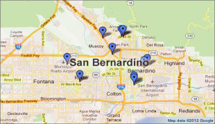
Map - San Bernardino International Airport (San Bernardino International Airport)
Map


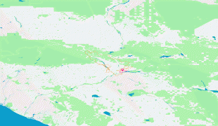


Country - United_States
 |
 |
| Flag of the United States | |
Indigenous peoples have inhabited the Americas for thousands of years. Beginning in 1607, British colonization led to the establishment of the Thirteen Colonies in what is now the Eastern United States. They quarreled with the British Crown over taxation and political representation, leading to the American Revolution and proceeding Revolutionary War. The United States declared independence on July 4, 1776, becoming the first nation-state founded on Enlightenment principles of unalienable natural rights, consent of the governed, and liberal democracy. The country began expanding across North America, spanning the continent by 1848. Sectional division surrounding slavery in the Southern United States led to the secession of the Confederate States of America, which fought the remaining states of the Union during the American Civil War (1861–1865). With the Union's victory and preservation, slavery was abolished nationally by the Thirteenth Amendment.
Currency / Language
| ISO | Currency | Symbol | Significant figures |
|---|---|---|---|
| USD | United States dollar | $ | 2 |
| ISO | Language |
|---|---|
| EN | English language |
| FR | French language |
| ES | Spanish language |