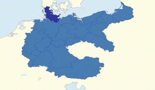
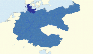
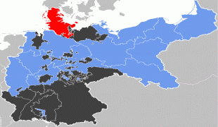
Schleswig-Holstein
 |
 |
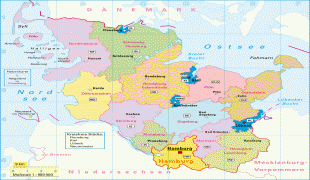
The region is called Slesvig-Holsten in Danish and pronounced. The Low German name is Sleswig-Holsteen, and the North Frisian name is Slaswik-Holstiinj. In more dated English, it is also known as Sleswick-Holsatia. Historically, the name can also refer to a larger region, containing both present-day Schleswig-Holstein and the former South Jutland County (Northern Schleswig; now part of the Region of Southern Denmark) in Denmark. It covers an area of 15763 km2, making it the 5th smallest German federal state by area (including the city-states).
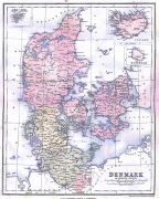
Schleswig was under Danish control during the Viking Age, but in the 12th century it escaped full control and became a duchy. It bordered Holstein, which was a part of the Holy Roman Empire. Beginning in 1460, both Schleswig and Holstein were ruled together by the Danish king acting as duke of both Schleswig and Holstein, with the latter remaining a part of Germany. In the 19th century, Danes and Germans each believed they had a claim to Schleswig-Holstein, the population of which was majority ethnic German. The resulting long-term political and territorial dispute was known as the Schleswig-Holstein Question. In 1848, Denmark tried to formally annex the area. Prussia responded by invading, thus beginning the First Schleswig War, which ended in a victory for Denmark and the signing of the 1852 London Protocol. But the fight broke out again in 1864 (the Second Schleswig War), and this time Prussia and Austria won and the territory was absorbed into Prussia in 1867. More than 50 years later, after the German defeat in World War I, the Allies required that the question of sovereignty over the territory be submitted to plebiscites (the 1920 Schleswig plebiscites), which resulted in the return of some of the territory to Denmark. After World War II, Schleswig-Holstein took in over a million refugees.
Today, Schleswig-Holstein's economy is known for its agriculture, such as its Holstein cows. Its position on the Atlantic Ocean makes it a major trade point and shipbuilding site; it is also the location of the Kiel Canal. Its offshore oil wells and wind farms produce significant amounts of energy. Fishing is a major industry, and the basis of its distinctive unique local cuisine. It is a popular tourist destination for Germans.
The term "Holstein" derives from Old Saxon Holseta Land, (Holz means wood in modern Standardized German; holt is a now-archaic English word for woods.) Originally, the term referred to the central of the three Saxon tribes north of the River Elbe: Tedmarsgoi (Dithmarschen), Holstein and Sturmarii (Stormarn). The area inhabited by the tribe of the Holsts lay between the Stör River and Hamburg; after Christianization, their main church was in Schenefeld. Saxon Holstein became a part of the Holy Roman Empire after Charlemagne's Saxon campaigns in the late eighth century. Beginning in 811, the northern border of Holstein (and thus of the Empire) was the River Eider.
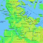
The term “Schleswig” originally referred to the city of Schleswig. The city's name derives from Schlei “inlet” in the east and vik, which meant inlet in Old Norse and settlement in Old Saxon, and is cognate with the "-wick" and "-wich" elements in place-names in Britain.
The Duchy of Schleswig, or Southern Jutland, was originally an integral part of Denmark, but in medieval times was established as a fief under the control of the Kingdom of Denmark, having the same relationship with the Danish Crown as, for example, Brandenburg or Bavaria had with the Holy Roman Emperor. Around 1100, the Duke of Saxony gave Holstein to Count Adolf I of Schauenburg.
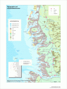
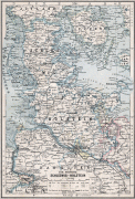
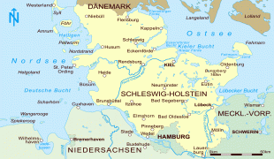
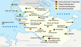
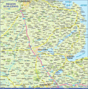
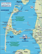
Map - Schleswig-Holstein
Map


Country - Germany
 |
 |
| Flag of Germany | |
Various Germanic tribes have inhabited the northern parts of modern Germany since classical antiquity. A region named Germania was documented before AD 100. In 962, the Kingdom of Germany formed the bulk of the Holy Roman Empire. During the 16th century, northern German regions became the centre of the Protestant Reformation. Following the Napoleonic Wars and the dissolution of the Holy Roman Empire in 1806, the German Confederation was formed in 1815.
Currency / Language
| ISO | Currency | Symbol | Significant figures |
|---|---|---|---|
| EUR | Euro | € | 2 |
| ISO | Language |
|---|---|
| DE | German language |


