Sikhuphe International Airport (Sikhuphe International Airport)
King Mswati III International Airport, initially named Sikhuphe International Airport in the planning and construction phase, is an airport in Eswatini. It replaced Matsapha Airport as the only international airport in Eswatini accepting commercial flights in 2014. It is designed to handle 360,000 passengers per year.
Construction began in 2003 on this $150m project. The Taiwanese government contributed US$22m to the project.
It is part of King Mswati III's $1bn millennium project investment initiative to enhance Eswatini's position as a tourist destination, serving as a tourism gateway to Eswatini's game parks, either domestic or nearby located ones, such as Victoria Falls, Maputo, the Kruger National Park and KwaZulu-Natal game reserves. However, it has been on the drawing board since 1980, and since then Kruger Mpumalanga International Airport has opened and Maputo and Durban airports have been upgraded. There are also environmental concerns since Sikhupe is near Hlane game park, and may put rare species of eagles and vultures at risk.
King Mswati III International Airport was planned to replace Matsapha airport by 2010, with the latter being taken over by the army.
King Mswati III International Airport was inaugurated on 7 March 2014, despite not yet having an IATA license to operate. Service began 30 September 2014.
Map - Sikhuphe International Airport (Sikhuphe International Airport)
Map
Country - Swaziland
 |
 |
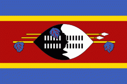
| Flag of Eswatini | |
The population is composed primarily of ethnic Swazis. The prevalent language is Swazi (siSwati in native form). The Swazis established their kingdom in the mid-18th century under the leadership of Ngwane III. The country and the Swazi take their names from Mswati II, the 19th-century king under whose rule the country was expanded and unified; its boundaries were drawn up in 1881 in the midst of the Scramble for Africa. After the Second Boer War, the kingdom, under the name of Swaziland, was a British high commission territory from 1903 until it regained its full independence on 6 September 1968. In April 2018, the official name was changed from Kingdom of Swaziland to Kingdom of Eswatini, mirroring the name commonly used in Swazi.
Currency / Language
| ISO | Currency | Symbol | Significant figures |
|---|---|---|---|
| SZL | Swazi lilangeni | L | 2 |
| ISO | Language |
|---|---|
| EN | English language |
| SS | Swati language |


