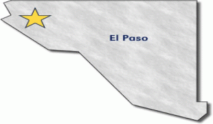
Western District (Western District)
The Western District is one of the primary divisions of American Samoa. It consists of the western portion of Tutuila Island. It has a land area of 74.781 km2 (28.873 sq mi) and contains 29 villages plus a part of Nu'uuli village. Among these is the largest village of American Samoa, Tafuna, at its eastern end. The district's total population as of the 2010 census was 31,329.
Dental and medical care to residents of the Western District are offered by Tafuna Community Health Center.
* Lealataua County
* Leasina County
* Tualatai County
* Tualauta County
Dental and medical care to residents of the Western District are offered by Tafuna Community Health Center.
* Lealataua County
* Leasina County
* Tualatai County
* Tualauta County
Map - Western District (Western District)
Map


Country - American_Samoa
 |
 |
American Samoa consists of five main islands and two coral atolls; the largest and most populous island is Tutuila, with the Manuʻa Islands, Rose Atoll and Swains Island also included in the territory. All islands except for Swains Island are part of the Samoan Islands, The total land area is 199 sqkm, slightly more than Washington, D.C. As of 2022, the population of American Samoa is approximately 45,443 people, of whom the vast majority are indigenous ethnic Samoans. Most American Samoans are bilingual and can speak English and Samoan fluently.
Currency / Language
| ISO | Currency | Symbol | Significant figures |
|---|---|---|---|
| USD | United States dollar | $ | 2 |
| ISO | Language |
|---|---|
| EN | English language |
| SM | Samoan language |
| TO | Tongan language |