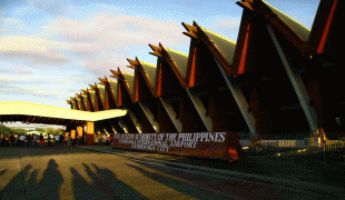
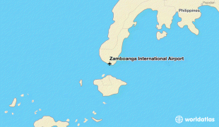
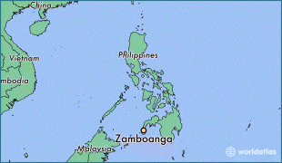
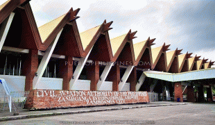
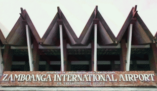
Zamboanga International Airport (Zamboanga International Airport)
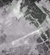
Zamboanga International Airport (Chavacano: Aeropuerto Internacional de Zamboanga; Paliparang Pandaigdig ng Zamboanga; ) is the main airport serving Zamboanga City in the Philippines. Located on a 270 ha site in Barangay Canelar, Zamboanga City, the airport is Mindanao's third-busiest airport after Francisco Bangoy International Airport in Davao City and Laguindingan Airport in Laguindingan, Misamis Oriental.
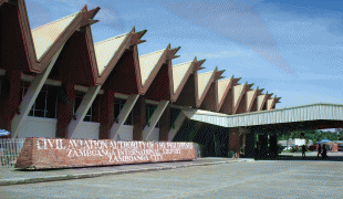
Despite being billed as an international airport, the airport is officially classified as a Class 1 principal domestic airport by the Civil Aviation Authority of the Philippines.
The airport started off as Moret Field, an American airfield that was constructed from a rather poor Japanese airfield just north of Zamboanga. Construction was started by Philippine Commonwealth troops just after American forces landed at the present location on March 15, 1945. It was improved by a U.S. Army airfield construction unit using considerable Filipino labor. When completed, the single runway was about 4,500 ft long aligned southwest to northeast. There were two adjacent taxiways along both sides of the runway with revetment areas. At the peak of operations in 1945, there were about 300 aircraft flying from the airfield. The vast majority were United States Marine Corps aircraft from Marine Aircraft Group 24 which were supporting U.S. Army & Philippine Army infantry operations on Mindanao but also ranging down the Sulu area as far as Borneo.
Subsequent improvements increased its capacity to hold flights. The airport used to service nearby international destinations in the past, such as Labuan and Sandakan in Malaysia via Philippine Airlines; Kota Kinabalu by Malaysia Airlines; and Tarakan in Indonesia by Bouraq Airlines; however, these international services were eventually cut.
On December 10, 2004, South Phoenix Airways announced their international flights to Sandakan and Kota Kinabalu in Malaysia, but it was eventually cut due to poor load of passengers. Likewise, Asian Spirit commenced service to Sandakan on May 2, 2007, restarting Zamboanga's international operations. The Zamboanga-Sandakan route and other international routes are expected to grow with the signing of a BIMP-EAGA open skies agreement, notably with Indonesia's Sriwijaya Air planning to fly the Zamboanga-Sandakan route.
Zamboanga International Airport, along with all other international airports in the Philippines, was placed under the control of the Manila International Airport Authority under Executive Order No. 341, signed by President Gloria Macapagal Arroyo on August 4, 2004. The changes in management were slated to take effect in June 2007.
Due to the US-RP Agreement, the US Air force used the airport while the Balikatan military exercises were held in the city. The biggest aircraft to land in Zamboanga International Airport is the Russian Antonov An-124-100 Ruslan made to deliver pickup trucks for the American training mission here in Zamboanga. North American Airlines Boeing 757-200s were chartered to transport American soldiers from Guam to Zamboanga. Boeing C-17 Globemaster IIIs flying from Okinawa come to Zamboanga every now and then. Gemini Air Cargo's DC-10 was once in Zamboanga Airport for delivery of the materials needed for the US Air Force training.
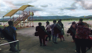
During the 2013 Zamboanga City crisis, the airport was closed to all civilian air traffic on September 9, and a no-fly zone was enforced within 25 mi of the airport. On September 19, the airport reopened to civilian flights as the security situation improved.
Due to its potential as a key-areas in the BIMP-EAGA zone, there are plans to reinstate its international routes. Cebgo initially planned to commence four weekly flights to Sandakan in October 2017. However, the flight was postponed due to operational issues. Flights to Kota Kinabalu operated by PAL Express De Havilland Canada Q400s were to begin on March 31, 2020, but did not push through as travel restrictions due to the COVID-19 pandemic were enforced. Nevertheless, the airline is still interested in launching this service as of February 2022.
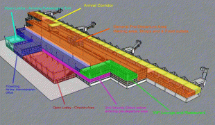
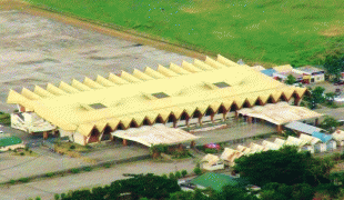
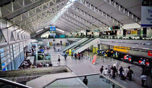
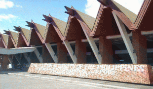
On September 28, 2021, the rehabilitated and expanded passenger terminal was inaugurated.
Despite being billed as an international airport, the airport is officially classified as a Class 1 principal domestic airport by the Civil Aviation Authority of the Philippines.
The airport started off as Moret Field, an American airfield that was constructed from a rather poor Japanese airfield just north of Zamboanga. Construction was started by Philippine Commonwealth troops just after American forces landed at the present location on March 15, 1945. It was improved by a U.S. Army airfield construction unit using considerable Filipino labor. When completed, the single runway was about 4,500 ft long aligned southwest to northeast. There were two adjacent taxiways along both sides of the runway with revetment areas. At the peak of operations in 1945, there were about 300 aircraft flying from the airfield. The vast majority were United States Marine Corps aircraft from Marine Aircraft Group 24 which were supporting U.S. Army & Philippine Army infantry operations on Mindanao but also ranging down the Sulu area as far as Borneo.
Subsequent improvements increased its capacity to hold flights. The airport used to service nearby international destinations in the past, such as Labuan and Sandakan in Malaysia via Philippine Airlines; Kota Kinabalu by Malaysia Airlines; and Tarakan in Indonesia by Bouraq Airlines; however, these international services were eventually cut.
On December 10, 2004, South Phoenix Airways announced their international flights to Sandakan and Kota Kinabalu in Malaysia, but it was eventually cut due to poor load of passengers. Likewise, Asian Spirit commenced service to Sandakan on May 2, 2007, restarting Zamboanga's international operations. The Zamboanga-Sandakan route and other international routes are expected to grow with the signing of a BIMP-EAGA open skies agreement, notably with Indonesia's Sriwijaya Air planning to fly the Zamboanga-Sandakan route.
Zamboanga International Airport, along with all other international airports in the Philippines, was placed under the control of the Manila International Airport Authority under Executive Order No. 341, signed by President Gloria Macapagal Arroyo on August 4, 2004. The changes in management were slated to take effect in June 2007.
Due to the US-RP Agreement, the US Air force used the airport while the Balikatan military exercises were held in the city. The biggest aircraft to land in Zamboanga International Airport is the Russian Antonov An-124-100 Ruslan made to deliver pickup trucks for the American training mission here in Zamboanga. North American Airlines Boeing 757-200s were chartered to transport American soldiers from Guam to Zamboanga. Boeing C-17 Globemaster IIIs flying from Okinawa come to Zamboanga every now and then. Gemini Air Cargo's DC-10 was once in Zamboanga Airport for delivery of the materials needed for the US Air Force training.
During the 2013 Zamboanga City crisis, the airport was closed to all civilian air traffic on September 9, and a no-fly zone was enforced within 25 mi of the airport. On September 19, the airport reopened to civilian flights as the security situation improved.
Due to its potential as a key-areas in the BIMP-EAGA zone, there are plans to reinstate its international routes. Cebgo initially planned to commence four weekly flights to Sandakan in October 2017. However, the flight was postponed due to operational issues. Flights to Kota Kinabalu operated by PAL Express De Havilland Canada Q400s were to begin on March 31, 2020, but did not push through as travel restrictions due to the COVID-19 pandemic were enforced. Nevertheless, the airline is still interested in launching this service as of February 2022.
On September 28, 2021, the rehabilitated and expanded passenger terminal was inaugurated.
| IATA Code | ZAM | ICAO Code | RPMZ | FAA Code | |
|---|---|---|---|---|---|
| Telephone | Fax | ||||
| Home page |
Map - Zamboanga International Airport (Zamboanga International Airport)
Map


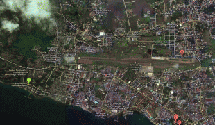
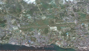
Country - Philippines
 |
 |
| Flag of the Philippines | |
Negritos, some of the archipelago's earliest inhabitants, were followed by successive waves of Austronesian peoples. Adoption of animism, Hinduism and Islam established island-kingdoms called Kedatuan, Rajahnates, and Sultanates. The arrival of Ferdinand Magellan, a Portuguese explorer leading a fleet for Spain, marked the beginning of Spanish colonization. In 1543, Spanish explorer Ruy López de Villalobos named the archipelago Las Islas Filipinas in honor of Philip II of Spain. Spanish settlement through Mexico, beginning in 1565, led to the Philippines becoming ruled by the Spanish Empire for more than 300 years. During this time, Catholicism became the dominant religion, and Manila became the western hub of trans-Pacific trade. In 1896, the Philippine Revolution began, which then became entwined with the 1898 Spanish–American War. Spain ceded the territory to the United States, while Filipino revolutionaries declared the First Philippine Republic. The ensuing Philippine–American War ended with the United States establishing control over the territory, which they maintained until the Japanese invasion of the islands during World War II. Following liberation, the Philippines became independent in 1946. Since then, the unitary sovereign state has often had a tumultuous experience with democracy, which included the overthrow of a decades-long dictatorship by a nonviolent revolution.
Currency / Language
| ISO | Currency | Symbol | Significant figures |
|---|---|---|---|
| PHP | Philippine peso | ₱ | 2 |
| ISO | Language |
|---|---|
| EN | English language |
| TL | Tagalog language |