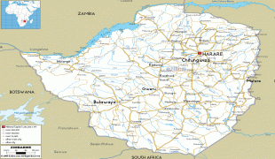
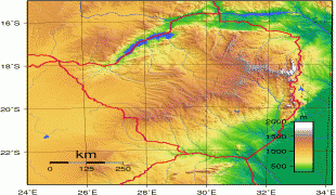
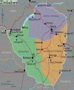
Zimbabwe (Republic of Zimbabwe)
 |
 |
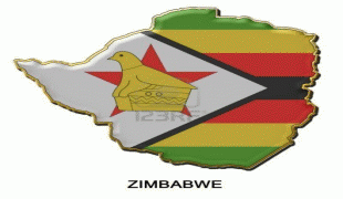
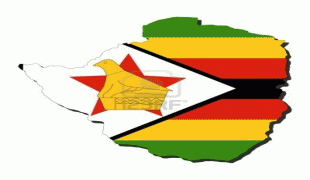
| Flag of Zimbabwe | |
The British South Africa Company of Cecil Rhodes demarcated the Rhodesia region in 1890 when they conquered Mashonaland and later in 1893 Matabeleland after a fierce resistance by Matabele people known as the First Matabele War. Company rule ended in 1923 with the establishment of Southern Rhodesia as a self-governing British colony. In 1965, the white minority government unilaterally declared independence as Rhodesia. The state endured international isolation and a 15-year guerrilla war with black nationalist forces; this culminated in a peace agreement that established universal enfranchisement and de jure sovereignty as Zimbabwe in April 1980. Zimbabwe then joined the Commonwealth of Nations, from which it was suspended in 2002 for breaches of international law by its government under Robert Mugabe and from which it withdrew in December 2003.
Mugabe became Prime Minister of Zimbabwe in 1980, when his ZANU–PF party won the general election following the end of white minority rule; he was the President of Zimbabwe from 1987 until his resignation in 2017. Under Mugabe's authoritarian regime, the state security apparatus dominated the country and was responsible for widespread human rights violations. From 2000 to 2009 the economy experienced decline and hyperinflation before rebounding after the use of currencies other than the Zimbabwean dollar was permitted, although growth has since faltered. On 15 November 2017, in the wake of over a year of protests against his government as well as Zimbabwe's rapidly declining economy, Mugabe was placed under house arrest by the country's national army in a coup d'état, and Mugabe resigned six days later. Emmerson Mnangagwa has since served as Zimbabwe's president.
Zimbabwe is a member of the United Nations, the Southern African Development Community, the African Union, and the Common Market for Eastern and Southern Africa.
The name "Zimbabwe" stems from a Shona term for Great Zimbabwe, a medieval city (Masvingo) in the country's south-east whose remains are now a protected site. Two different theories address the origin of the word. Many sources hold that "Zimbabwe" derives from dzimba-dza-mabwe, translated from the Karanga dialect of Shona as "houses of stones" (dzimba = plural of imba, "house"; mabwe = plural of ibwe, "stone"). The Karanga-speaking Shona people live around Great Zimbabwe in the modern-day Masvingo province. Archaeologist Peter Garlake claims that "Zimbabwe" represents a contracted form of dzimba-hwe, which means "venerated houses" in the Zezuru dialect of Shona and usually references chiefs' houses or graves.
Zimbabwe was formerly known as Southern Rhodesia (1898), Rhodesia (1965), and Zimbabwe Rhodesia (1979). The first recorded use of "Zimbabwe" as a term of national reference dates from 1960 as a coinage by the black nationalist Michael Mawema, whose Zimbabwe National Party became the first to officially use the name in 1961. The term "Rhodesia"—derived from the surname of Cecil Rhodes, the primary instigator of British colonisation of the territory during the late 19th century—was perceived by African nationalists as inappropriate because of its colonial origin and connotations.
According to Mawema, black nationalists held a meeting in 1960 to choose an alternative name for the country, proposing names such as "Matshobana" and "Monomotapa" before his suggestion, "Zimbabwe", prevailed. A further alternative, put forward by nationalists in Matabeleland, had been "Matopos", referring to the Matopos Hills to the south of Bulawayo.
It was initially unclear how the chosen term was to be used—a letter written by Mawema in 1961 refers to "Zimbabweland" — but "Zimbabwe" was sufficiently established by 1962 to become the generally preferred term of the black nationalist movement. In a 2001 interview, black nationalist Eddison Zvobgo recalled that Mawema mentioned the name during a political rally, "and it caught hold, and that was that". The black nationalist factions subsequently used the name during the Second Chimurenga campaigns against the Rhodesian government during the Rhodesian Bush War of 1964–1979. Major factions in this camp included the Zimbabwe African National Union (led by Robert Mugabe from 1975), and the Zimbabwe African People's Union (led by Joshua Nkomo from its founding in the early 1960s).
Currency / Language
| ISO | Currency | Symbol | Significant figures |
|---|---|---|---|
| ZWL | Zimbabwean dollar | 2 |
| ISO | Language |
|---|---|
| SN | Shona language |