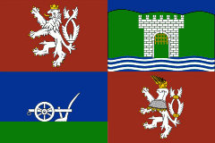
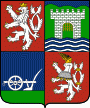
Ústí nad Labem Region (Ústecký kraj)
 |
 |
The region borders the regions of Liberec (east), Central Bohemia (south), Plzeň (southwest), Karlovy Vary (west) and the German region of Saxony to the north.
The Ústí region comprises a range of very different types of landscape. Between the high escarpment of the Ore Mountains (Krušné hory) range and the Bohemian Central Uplands with many volcanic hills, there are vast areas devastated by surface coal mining (the North Bohemian Basin), partly being recultivated into an artificial landscape with ponds, plains and groves. The Elbe river runs through the Central Uplands in a winding gorge of the Porta Bohemica. The southern part of the region, Polabí, is flat and fertile, while in the northeast are the sandstone formations of Bohemian Switzerland, including the monumental Pravčická brána, a natural sandstone arch. The geographical location of the area, between Prague and Germany, has been a significant factor in the region’s development.
The Ústí nad Labem Region is divided into 7 districts:
The districts are further subdivided into 16 ORP districts (administrative districts of the municipalities with extended competence).
Map - Ústí nad Labem Region (Ústecký kraj)
Map


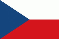
Country - Czech_Republic
 |
 |
| Flag of the Czech Republic | |
The Duchy of Bohemia was founded in the late 9th century under Great Moravia. It was formally recognized as an Imperial State of the Holy Roman Empire in 1002 and became a kingdom in 1198. Following the Battle of Mohács in 1526, the whole Crown of Bohemia was gradually integrated into the Habsburg monarchy. The Protestant Bohemian Revolt led to the Thirty Years' War. After the Battle of White Mountain, the Habsburgs consolidated their rule. With the dissolution of the Holy Empire in 1806, the Crown lands became part of the Austrian Empire.
Currency / Language
| ISO | Currency | Symbol | Significant figures |
|---|---|---|---|
| CZK | Czech koruna | KÄ | 2 |
| ISO | Language |
|---|---|
| CS | Czech language |
| SK | Slovak language |
