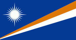
Flag of the Marshall Islands
The flag of the Marshall Islands, an island nation in the Pacific, was adopted upon the start of self-government, May 1, 1979. The flag was designed by Emlain Kabua, who served as the first First Lady of the republic.
Rules and specifications regarding the flag are set forth in the Official Flag of the Marshall Islands Act 1979 (Public Law 1979–1).
The Marshall Islands were part of the Trust Territory of the Pacific Islands administered by the United States, from which the Marshall Islands, Palau, and the Federated States of Micronesia split. In common with other island nations in the region, this flag features the symbolic representation of the islands' place within the ocean. The rising diagonal band represents the equator, the star above representing this Northern Hemisphere archipelago. The white and orange portions of the band represent, respectively, the Ratak Chain ("sunrise") and the Ralik Chain ("sunset"), as well as symbolizing peace and courage. The star's 24 points represent the number of electoral districts, while the four elongated points represent the principal cultural centers of Majuro, Jaluit, Wotje and Ebeye. The flag is also the national flag with the most points on a star, at 24.
National flag
Country - Marshall_Islands
Warning: getimagesize(/Image/Map/MP2080185.gif): failed to open stream: No such file or directory in /home/mapnlee7/public_html/MAPNALL/article.php on line 532
 |
 |
The country's population of 42,050 people (at the 2021 World Bank Census ) is spread out over five islands and 29 coral atolls, comprising 1,156 individual islands and islets. The capital and largest city is Majuro. It has the largest portion of its territory composed of water of any sovereign state, at 97.87%. The islands share maritime boundaries with Wake Island to the north, Kiribati to the southeast, Nauru to the south, and the Federated States of Micronesia to the west. About 52.3% of Marshall Islanders (27,797 at the 2011 Census) live on Majuro. In 2016, 73.3% of the population were defined as being "urban". The UN also indicates a population density of 295 PD/km2, and its projected 2020 population is 59,190.
