Flag of Equatorial Guinea
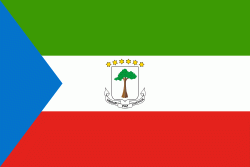
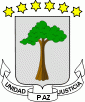
The flag of Equatorial Guinea (Bandera de Guinea Ecuatorial; Drapeau de la Guinée équatoriale; Bandeira da Guiné Equatorial) was adopted on August 21, 1979. The six stars on the map represent the country's mainland and five islands. Under the rule of dictator Francisco Nguema the flag was modified and a different national emblem was used in it. After he was deposed the original flag was restored.
The flag is a horizontal tricolor, with green, white and red stripes and a blue triangle at the hoist. Green symbolizes the natural resources, agriculture and jungles of the country. Blue symbolizes the sea, which connects the mainland with the islands. White symbolizes peace. Red symbolizes the blood shed by the fighters for independence.
The flag is a horizontal tricolor, with green, white and red stripes and a blue triangle at the hoist. Green symbolizes the natural resources, agriculture and jungles of the country. Blue symbolizes the sea, which connects the mainland with the islands. White symbolizes peace. Red symbolizes the blood shed by the fighters for independence.
National flag
Country - Equatorial_Guinea
Warning: getimagesize(/Image/Map/MP2309096.gif): failed to open stream: No such file or directory in /home/mapnlee7/public_html/MAPNALL/article.php on line 532
 |
 |
Equatorial Guinea consists of two parts, an insular and a mainland region. The insular region consists of the islands of Bioko (formerly Fernando Pó) in the Gulf of Guinea and Annobón, a small volcanic island which is the only part of the country south of the equator. Bioko Island is the northernmost part of Equatorial Guinea and is the site of the country's capital, Malabo. The Portuguese-speaking island nation of São Tomé and Príncipe is located between Bioko and Annobón. The mainland region, Río Muni, is bordered by Cameroon on the north and Gabon on the south and east. It is the location of Bata, Equatorial Guinea's largest city, and Ciudad de la Paz, the country's planned future capital. Rio Muni also includes several small offshore islands, such as Corisco, Elobey Grande, and Elobey Chico. The country is a member of the African Union, Francophonie, OPEC and the CPLP.