Plateaux Region (Plateaux)
Atakpamé is the regional capital. It is the largest region in terms of area and has the second largest population (after the Maritime Region). Other major cities in the Plateaux region include Kpalimé and Badou. The highest point of the country, Mount Agou, is located within this region.
Plateaux is located north of Maritime Region and south of Centrale Region. In the west, it borders the Volta Region of Ghana, and in the east it borders three departments of Benin: Collines to the northeast; Zou to the east; and Kouffo to the southeast.
Plateaux is divided into the prefectures of:
* Agou Prefecture
* Amou Prefecture
* Danyi Prefecture
* Est-Mono Prefecture
* Haho Prefecture
* Kloto Prefecture
Map - Plateaux Region (Plateaux)
Map


Country - Togo
 |
 |
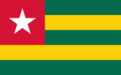
| Flag of Togo | |
Various people groups settled the boundaries of present day Togo between the 11th to 16th centuries. Between the 16th and 18th centuries, the coastal region served primarily as a European slave trading outpost, earning Togo and the surrounding region the name "The Slave Coast". In 1884, Germany declared a region including a protectorate called Togoland. After World War I, rule over Togo was transferred to France. Togo gained its independence from France in 1960. In 1967, Gnassingbé Eyadéma led a successful military coup d'état, after which he became president of an anti-communist, single-party state. In 1993, Eyadéma faced multiparty elections marred by irregularities, and won the presidency three times. At the time of his death, Eyadéma was the "longest-serving leader in modern African history", having been president for 38 years. In 2005, his son Faure Gnassingbé was elected president.
Currency / Language
| ISO | Currency | Symbol | Significant figures |
|---|---|---|---|
| XOF | West African CFA franc | Fr | 0 |
| ISO | Language |
|---|---|
| EE | Ewe language |
| FR | French language |
| HA | Hausa language |